Randonnée Marche Canohès - las canals canohes 10km 2h   - Photo
 Erius
Erius

Utilisateur

© OpenStreetMap contributors
Longueur
Longueur
9,6 km
Altitude max
Altitude max
69 m
Dénivelé positif
Dénivelé positif
51 m
Km-Effort
Km-Effort  
10,3 km
Altitude min
Altitude min
55 m
Dénivelé négatif
Dénivelé négatif
51 m
Boucle
Boucle
Oui
Date de création :
2023-06-23 05:51:38.899
Dernière modification :
2023-06-23 08:09:11.886

(0 Avis)

Marche
Marche
2h09
Difficulté : Facile

Scannez ce code QR pour ouvrir la randonnée dans l'application SityTrail

Application GPS de randonnée GRATUITE

Logo SityTrail SityTrail

IGN / Instituts géographiques

Télécharger SityTrail sur l'App Store Télécharger SityTrail sur Google Play

Logo SityTrail SityTrail World

Le monde est à vous

Télécharger SityTrail sur l'App Store Télécharger SityTrail sur Google Play Télécharger SityTrail sur Huawei AppGallery

À propos

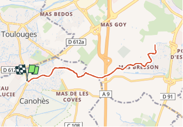
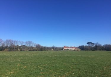
Randonnée Marche de 9,6 km à découvrir à Occitanie, Pyrénées-Orientales, Canohès. Cette randonnée est proposée par Erius.

Description

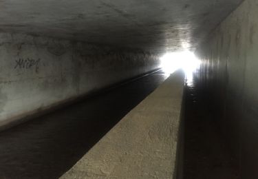
piste - chemin ombragé de platanes et de chênes, le long du canal de canohes à Auchan.

Profil altimétrique

Localisation

Pays :
France
Région :
Occitanie
Département/Province :
Pyrénées-Orientales
Commune :
Canohès
Localité :
Unknown
Départ:(UTM)
486446 ; 4722886 (31T) N.

Randonnées à proximité

Randonnée Marche Perpignan - Perpignan 01.10.2017  - Photo
Marche
jeff66

Marche

Facile
(1)
Perpignan, Occitanie, Pyrénées-Orientales, France
6,7 km | 7,5 km-effort
1h 39min
Non
Randonnée V.T.T. Canohès - canohes - Photo
V.T.T.
haroldtheviking

V.T.T.

Moyen
(2)
Canohès, Occitanie, Pyrénées-Orientales, France
37 km | 44 km-effort
2h 12min
Oui
Randonnée Marche Perpignan - canal Perpignan  - Photo
Marche
Fildesir

Marche

Très facile
Perpignan, Occitanie, Pyrénées-Orientales, France
25 km | 27 km-effort
7h 29min
Non
Randonnée Marche Perpignan - 66 Perpignan Panchot centre bas Vernet centre del mon - Photo
Marche
jeff66

Marche

Facile
Perpignan, Occitanie, Pyrénées-Orientales, France
8,6 km | 9,3 km-effort
1h 29min
Oui
Randonnée Marche Perpignan - 66 PERPIGNAN - autour des mas Du petit et du grand Bresson - Photo
Marche
jeff66

Marche

Facile
Perpignan, Occitanie, Pyrénées-Orientales, France
4,3 km | 4,9 km-effort
52min
Oui
Randonnée Marche Perpignan - 66 PERPIGNAN, du sud au Nord Et retour - Photo
Marche
jeff66

Marche

Moyen
Perpignan, Occitanie, Pyrénées-Orientales, France
13,8 km | 15,4 km-effort
2h 40min
Oui
Randonnée Marche Perpignan - 66 PERPIGNAN - CANOHES par le canal et le ch. des Carlettes - Photo
Marche
jeff66

Marche

Moyen
(1)
Perpignan, Occitanie, Pyrénées-Orientales, France
9,4 km | 10,1 km-effort
1h 45min
Oui
Randonnée Marche Perpignan - 66 PERPIGNAN porte Espagne, les arcades, saint Martin, moulin à vent, vertefeuille, mas Gaffard - Photo
Marche
jeff66

Marche

Moyen
Perpignan, Occitanie, Pyrénées-Orientales, France
10,3 km | 11,7 km-effort
1h 48min
Oui
Randonnée Marche Baho - 66 SAINT-ESTEVE, promenade entre jardins, canaux et centre ville - Photo
Marche
jeff66

Marche

Facile
Baho, Occitanie, Pyrénées-Orientales, France
6,9 km | 7,3 km-effort
1h 16min
Oui


Fermer
Mes abonnements