![](/images/other/stat-length.png)
![Randonnée Marche Maincy - JC 62 - 20 km De Maincy à Blandy les Tours - Photo](https://media.geolcdn.com/t/1900/400/ext.pjpeg?maxdim=2&url=https%3A%2F%2Fstatic1.geolcdn.com%2Fsiteimages%2Fupload%2Ffiles%2F1553511878bg_sport_marche.png)
JC 62 - 20 km De Maincy à Blandy les Tours
Les 1000 pattes
Club randonnées SERVON
![Longueur](/images/other/stat-length.png)
Longueur
19,9 km
![Altitude max](https://static1.geolcdn.com/siteimages/upload/files/1508320355ic_sort_altitude_max_24dp.png)
Altitude max
101 m
![Dénivelé positif](https://static1.geolcdn.com/siteimages/upload/files/1508320355ic_sort_den_pos_24dp.png)
Dénivelé positif
227 m
![Km-Effort](/images/other/stat-length.png)
Km-Effort
23 km
![Altitude min](https://static1.geolcdn.com/siteimages/upload/files/1508320355ic_sort_altitude_min_24dp.png)
Altitude min
43 m
![Dénivelé négatif](https://static1.geolcdn.com/siteimages/upload/files/1508320355ic_sort_den_neg_24dp.png)
Dénivelé négatif
227 m
![Boucle](https://static1.geolcdn.com/siteimages/upload/files/16400158638029165_repeat_loop_refresh_sync_direction_icon.png)
Boucle
Oui
Date de création :
2023-06-21 16:00:44.339
Dernière modification :
2023-06-21 17:47:11.549
![Marche](https://static1.geolcdn.com/sitytour/trail-icons/101.png)
5h15
Difficulté : Difficile
![Scannez ce code QR pour ouvrir la randonnée dans l'application SityTrail](https://capi.geolives.com/qq0zvz2zws4bq2lad0pu/sitytour/trails/3707715/qr.png?size=200)
Application GPS de randonnée GRATUITE
À propos
Randonnée Marche de 19,9 km à découvrir à Île-de-France, Seine-et-Marne, Maincy. Cette randonnée est proposée par Les 1000 pattes.
Description
Parking Rue du Pavé de l'Eglise à Maincy (place de l'église)
Trajet Servon-->Maincy (25km: 26mn)
A éviter car beaucoup de trajet le long de RN, préférer la JC15
Localisation
Pays :
France
Région :
Île-de-France
Département/Province :
Seine-et-Marne
Commune :
Maincy
Localité :
Unknown
Départ:(Dec)
Départ:(UTM)
477805 ; 5377524 (31U) N.
Commentaires
Randonnées à proximité
![Randonnée V.T.T. Melun - melun-bas.samois - Photo](https://media.geolcdn.com/t/375/260/ext.jpg?maxdim=2&url=https%3A%2F%2Fservices.sitytrail.com%2FGeolivesWS%2FDownloadMedia.ashx%3FTrailID%3D201635%26Media%3D20130630104925.jpeg)
![V.T.T. V.T.T.](https://static1.geolcdn.com/sitytour/trail-icons/202.png)
melun-bas.samois
V.T.T.
Moyen
(1)
Melun,
Île-de-France,
Seine-et-Marne,
France
![](/images/other/stat-length.png)
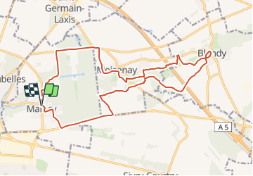
38 km | 43 km-effort
2h 45min
![](https://static1.geolcdn.com/siteimages/upload/files/16400158638029165_repeat_loop_refresh_sync_direction_icon.png)
Oui
![Randonnée Marche Melun - Le tour du Grand Paris via le gr1 : Etape 13 Melun Barbizon - Photo](https://media.geolcdn.com/t/375/260/43fa91c6-5130-4300-b61c-33f1d532d9df.jpg&format=jpg&maxdim=2)
![Marche Marche](https://static1.geolcdn.com/sitytour/trail-icons/101.png)
Le tour du Grand Paris via le gr1 : Etape 13 Melun Barbizon
Marche
Facile
Melun,
Île-de-France,
Seine-et-Marne,
France
![](/images/other/stat-length.png)
27 km | 33 km-effort
5h 55min
![](https://static1.geolcdn.com/siteimages/upload/files/16400158638029165_repeat_loop_refresh_sync_direction_icon.png)
Non
![Randonnée A pied Maincy - L 40 Sur les pas de Paul Cézanne à Maincy - Photo](https://media.geolcdn.com/t/375/260/ext.jpg?maxdim=2&url=https%3A%2F%2Fstatic1.geolcdn.com%2Fsiteimages%2Fupload%2Ffiles%2F1545311037marcheuse_200dpi.jpg)
![A pied A pied](https://static1.geolcdn.com/sitytour/trail-icons/100.png)
L 40 Sur les pas de Paul Cézanne à Maincy
A pied
Très facile
(3)
Maincy,
Île-de-France,
Seine-et-Marne,
France
![](/images/other/stat-length.png)
6 km | 7,2 km-effort
1h 38min
![](https://static1.geolcdn.com/siteimages/upload/files/16400158638029165_repeat_loop_refresh_sync_direction_icon.png)
Oui
![Randonnée Marche Maincy - vaux le pénil - blandy les tours - Photo](https://media.geolcdn.com/t/375/260/5344f78f-37de-4136-b4f8-4ce06f4e96e0.jpg&format=jpg&maxdim=2)
![Marche Marche](https://static1.geolcdn.com/sitytour/trail-icons/101.png)
vaux le pénil - blandy les tours
Marche
Très facile
Maincy,
Île-de-France,
Seine-et-Marne,
France
![](/images/other/stat-length.png)
21 km | 24 km-effort
5h 44min
![](https://static1.geolcdn.com/siteimages/upload/files/16400158638029165_repeat_loop_refresh_sync_direction_icon.png)
Oui
![Randonnée Marche Melun - Melun -- charrettes - Photo](https://media.geolcdn.com/t/375/260/ext.jpg?maxdim=2&url=https%3A%2F%2Fservices.sitytrail.com%2FGeolivesWS%2FDownloadMedia.ashx%3FTrailID%3D201785%26Media%3D20130630163457.jpg)
![Marche Marche](https://static1.geolcdn.com/sitytour/trail-icons/101.png)
Melun -- charrettes
Marche
Très facile
Melun,
Île-de-France,
Seine-et-Marne,
France
![](/images/other/stat-length.png)
14,7 km | 16,5 km-effort
3h 48min
![](https://static1.geolcdn.com/siteimages/upload/files/16400158638029165_repeat_loop_refresh_sync_direction_icon.png)
Non
![Randonnée Marche Le Mée-sur-Seine - Melun 01 - Photo](https://media.geolcdn.com/t/375/260/ext.jpg?maxdim=2&url=https%3A%2F%2Fservices.sitytrail.com%2FGeolivesWS%2FDownloadMedia.ashx%3FTrailID%3D183579%26Media%3D20130407182853.jpg)
![Marche Marche](https://static1.geolcdn.com/sitytour/trail-icons/101.png)
Melun 01
Marche
Très facile
Le Mée-sur-Seine,
Île-de-France,
Seine-et-Marne,
France
![](/images/other/stat-length.png)
8 km | 9,1 km-effort
4h 26min
![](https://static1.geolcdn.com/siteimages/upload/files/16400158638029165_repeat_loop_refresh_sync_direction_icon.png)
Non
![Randonnée Vélo Melun - melun bas samois 2011-10-30 12h04m11 - Photo](https://media.geolcdn.com/t/375/260/ext.jpg?maxdim=2&url=https%3A%2F%2Fstatic1.geolcdn.com%2Fsiteimages%2Fupload%2Ffiles%2F1524743154velo.jpg)
![Vélo Vélo](https://static1.geolcdn.com/sitytour/trail-icons/200.png)
melun bas samois 2011-10-30 12h04m11
Vélo
Moyen
(1)
Melun,
Île-de-France,
Seine-et-Marne,
France
![](/images/other/stat-length.png)
39 km | 44 km-effort
Inconnu
![](https://static1.geolcdn.com/siteimages/upload/files/16400158638029165_repeat_loop_refresh_sync_direction_icon.png)
Oui
![Randonnée Marche Maincy - 3 chateaux - Photo](https://media.geolcdn.com/t/375/260/292423c5-20b3-4ed0-abe4-a1a9ed13f5c8.jpg&format=jpg&maxdim=2)
![Marche Marche](https://static1.geolcdn.com/sitytour/trail-icons/101.png)
3 chateaux
Marche
Moyen
Maincy,
Île-de-France,
Seine-et-Marne,
France
![](/images/other/stat-length.png)
26 km | 29 km-effort
6h 32min
![](https://static1.geolcdn.com/siteimages/upload/files/16400158638029165_repeat_loop_refresh_sync_direction_icon.png)
Non
![Randonnée Marche Melun - blandy - Photo](https://media.geolcdn.com/t/375/260/5fa1f321-d94f-4615-aead-b2be579680ca.jpg&format=jpg&maxdim=2)
![Marche Marche](https://static1.geolcdn.com/sitytour/trail-icons/101.png)
blandy
Marche
Difficile
Melun,
Île-de-France,
Seine-et-Marne,
France
![](/images/other/stat-length.png)
14 km | 16,2 km-effort
3h 9min
![](https://static1.geolcdn.com/siteimages/upload/files/16400158638029165_repeat_loop_refresh_sync_direction_icon.png)
Non