![](/images/other/stat-length.png)
![Randonnée Marche Sailhan - Sailhan Granges d'Arsoué Ens 7-12km D+330m - Photo](https://media.geolcdn.com/t/1900/400/ext.pjpeg?maxdim=2&url=https%3A%2F%2Fstatic1.geolcdn.com%2Fsiteimages%2Fupload%2Ffiles%2F1553511878bg_sport_marche.png)
Sailhan Granges d'Arsoué Ens 7-12km D+330m
YV24
Utilisateur
![Longueur](/images/other/stat-length.png)
Longueur
7,1 km
![Altitude max](https://static1.geolcdn.com/siteimages/upload/files/1508320355ic_sort_altitude_max_24dp.png)
Altitude max
1201 m
![Dénivelé positif](https://static1.geolcdn.com/siteimages/upload/files/1508320355ic_sort_den_pos_24dp.png)
Dénivelé positif
334 m
![Km-Effort](/images/other/stat-length.png)
Km-Effort
11,6 km
![Altitude min](https://static1.geolcdn.com/siteimages/upload/files/1508320355ic_sort_altitude_min_24dp.png)
Altitude min
914 m
![Dénivelé négatif](https://static1.geolcdn.com/siteimages/upload/files/1508320355ic_sort_den_neg_24dp.png)
Dénivelé négatif
334 m
![Boucle](https://static1.geolcdn.com/siteimages/upload/files/16400158638029165_repeat_loop_refresh_sync_direction_icon.png)
Boucle
Oui
Date de création :
2023-06-20 08:31:01.082
Dernière modification :
2023-06-20 14:02:08.86
![Marche](https://static1.geolcdn.com/sitytour/trail-icons/101.png)
2h37
Difficulté : Moyen
![Scannez ce code QR pour ouvrir la randonnée dans l'application SityTrail](https://capi.geolives.com/qq0zvz2zws4bq2lad0pu/sitytour/trails/3706269/qr.png?size=200)
Application GPS de randonnée GRATUITE
À propos
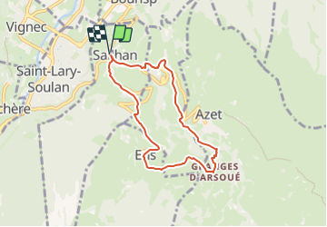
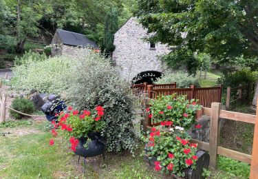
Randonnée Marche de 7,1 km à découvrir à Occitanie, Hautes-Pyrénées, Sailhan. Cette randonnée est proposée par YV24.
Description
Depuis l'église de Sailhan. Tracé varié, chemin creux, 2 petits raidillons en début et fin de tracé, pas trop de bitume. A éviter après fortes pluies.
Localisation
Pays :
France
Région :
Occitanie
Département/Province :
Hautes-Pyrénées
Commune :
Sailhan
Localité :
Unknown
Départ:(Dec)
Départ:(UTM)
282039 ; 4744310 (31T) N.
Commentaires
Randonnées à proximité
![Randonnée Marche Azet - col azet - Photo](https://media.geolcdn.com/t/375/260/ext.jpg?maxdim=2&url=https%3A%2F%2Fservices.sitytrail.com%2FGeolivesWS%2FDownloadMedia.ashx%3FTrailID%3D149546%26Media%3D20120817125202.jpg)
![Marche Marche](https://static1.geolcdn.com/sitytour/trail-icons/101.png)
col azet
Marche
Facile
(1)
Azet,
Occitanie,
Hautes-Pyrénées,
France
![](/images/other/stat-length.png)
6,4 km | 9,2 km-effort
2h 10min
![](https://static1.geolcdn.com/siteimages/upload/files/16400158638029165_repeat_loop_refresh_sync_direction_icon.png)
Oui
![Randonnée Marche Saint-Lary-Soulan - 2011-08-03 15h51m06 - Photo](https://media.geolcdn.com/t/375/260/ext.jpg?maxdim=2&url=https%3A%2F%2Fservices.sitytrail.com%2FGeolivesWS%2FDownloadMedia.ashx%3FTrailID%3D70666%26Media%3D20110803154635.jpeg)
![Marche Marche](https://static1.geolcdn.com/sitytour/trail-icons/101.png)
2011-08-03 15h51m06
Marche
Très facile
(2)
Saint-Lary-Soulan,
Occitanie,
Hautes-Pyrénées,
France
![](/images/other/stat-length.png)
6,8 km | 9,8 km-effort
Inconnu
![](https://static1.geolcdn.com/siteimages/upload/files/16400158638029165_repeat_loop_refresh_sync_direction_icon.png)
Oui
![Randonnée Marche Ens - lacs de Consaterre - Photo](https://media.geolcdn.com/t/375/260/ext.jpg?maxdim=2&url=https%3A%2F%2Fstatic1.geolcdn.com%2Fsiteimages%2Fupload%2Ffiles%2F1553511878bg_sport_marche.png)
![Marche Marche](https://static1.geolcdn.com/sitytour/trail-icons/101.png)
lacs de Consaterre
Marche
Difficile
(1)
Ens,
Occitanie,
Hautes-Pyrénées,
France
![](/images/other/stat-length.png)
16,5 km | 34 km-effort
6h 56min
![](https://static1.geolcdn.com/siteimages/upload/files/16400158638029165_repeat_loop_refresh_sync_direction_icon.png)
Oui
![Randonnée Marche Azet - Au col d'Azet - Photo](https://media.geolcdn.com/t/375/260/ext.jpg?maxdim=2&url=https%3A%2F%2Fstatic1.geolcdn.com%2Fsiteimages%2Fupload%2Ffiles%2F1553511878bg_sport_marche.png)
![Marche Marche](https://static1.geolcdn.com/sitytour/trail-icons/101.png)
Au col d'Azet
Marche
Moyen
(1)
Azet,
Occitanie,
Hautes-Pyrénées,
France
![](/images/other/stat-length.png)
7,3 km | 10,5 km-effort
2h 19min
![](https://static1.geolcdn.com/siteimages/upload/files/16400158638029165_repeat_loop_refresh_sync_direction_icon.png)
Oui
![Randonnée Marche Azet - J4 Néouvelle 2024 : Col d’Azet - Photo](https://media.geolcdn.com/t/375/260/9d44ad7c-f24c-41b8-a1e4-5c7ed0850111.jpg&format=jpg&maxdim=2)
![Marche Marche](https://static1.geolcdn.com/sitytour/trail-icons/101.png)
J4 Néouvelle 2024 : Col d’Azet
Marche
Moyen
Azet,
Occitanie,
Hautes-Pyrénées,
France
![](/images/other/stat-length.png)
13,7 km | 21 km-effort
4h 40min
![](https://static1.geolcdn.com/siteimages/upload/files/16400158638029165_repeat_loop_refresh_sync_direction_icon.png)
Oui
![Randonnée Marche Azet - 2023-09-10 Azet-Col d'Azet crète de la Serre - Photo](https://media.geolcdn.com/t/375/260/a241488d-7806-4d31-8df1-c552ae8f09f7.jpg&format=jpg&maxdim=2)
![Marche Marche](https://static1.geolcdn.com/sitytour/trail-icons/101.png)
2023-09-10 Azet-Col d'Azet crète de la Serre
Marche
Très difficile
Azet,
Occitanie,
Hautes-Pyrénées,
France
![](/images/other/stat-length.png)
11,8 km | 19,4 km-effort
4h 24min
![](https://static1.geolcdn.com/siteimages/upload/files/16400158638029165_repeat_loop_refresh_sync_direction_icon.png)
Oui
![Randonnée sport Tramezaïgues - Au dessus de tramezaigues - Photo](https://media.geolcdn.com/t/375/260/6241ad0b-d07e-4c7e-b6a4-b04d00176721.jpg&format=jpg&maxdim=2)
Au dessus de tramezaigues
sport
Très facile
Tramezaïgues,
Occitanie,
Hautes-Pyrénées,
France
![](/images/other/stat-length.png)
3 km | 5,8 km-effort
Inconnu
![](https://static1.geolcdn.com/siteimages/upload/files/16400158638029165_repeat_loop_refresh_sync_direction_icon.png)
Oui
![Randonnée Marche Saint-Lary-Soulan - AZET : Pla d’Ourtigué en boucle - Photo](https://media.geolcdn.com/t/375/260/61d95884-b483-4a11-b2a1-350e3c3e812e.jpg&format=jpg&maxdim=2)
![Marche Marche](https://static1.geolcdn.com/sitytour/trail-icons/101.png)
AZET : Pla d’Ourtigué en boucle
Marche
Moyen
Saint-Lary-Soulan,
Occitanie,
Hautes-Pyrénées,
France
![](/images/other/stat-length.png)
16,9 km | 25 km-effort
4h 22min
![](https://static1.geolcdn.com/siteimages/upload/files/16400158638029165_repeat_loop_refresh_sync_direction_icon.png)
Non
![Randonnée Marche Saint-Lary-Soulan - Vieille Aure-Trachère - Photo](https://media.geolcdn.com/t/375/260/939f9075-2a66-47f6-ada4-2a25ac95fa43.jpg&format=jpg&maxdim=2)
![Marche Marche](https://static1.geolcdn.com/sitytour/trail-icons/101.png)
Vieille Aure-Trachère
Marche
Moyen
Saint-Lary-Soulan,
Occitanie,
Hautes-Pyrénées,
France
![](/images/other/stat-length.png)
14,4 km | 20 km-effort
3h 46min
![](https://static1.geolcdn.com/siteimages/upload/files/16400158638029165_repeat_loop_refresh_sync_direction_icon.png)
Oui