![](/images/other/stat-length.png)
![Randonnée Marche Thuin - La Ragnicole - Photo](https://media.geolcdn.com/t/1900/400/ext.pjpeg?maxdim=2&url=https%3A%2F%2Fstatic1.geolcdn.com%2Fsiteimages%2Fupload%2Ffiles%2F1553511878bg_sport_marche.png)
La Ragnicole
Maison du Tourisme du Val de Sambre et de Thudinie
Randonnées de la Maison du Tourisme du Val de Sambre et de Thudinie
![Longueur](/images/other/stat-length.png)
Longueur
4,9 km
![Altitude max](https://static1.geolcdn.com/siteimages/upload/files/1508320355ic_sort_altitude_max_24dp.png)
Altitude max
180 m
![Dénivelé positif](https://static1.geolcdn.com/siteimages/upload/files/1508320355ic_sort_den_pos_24dp.png)
Dénivelé positif
40 m
![Km-Effort](/images/other/stat-length.png)
Km-Effort
5,4 km
![Altitude min](https://static1.geolcdn.com/siteimages/upload/files/1508320355ic_sort_altitude_min_24dp.png)
Altitude min
164 m
![Dénivelé négatif](https://static1.geolcdn.com/siteimages/upload/files/1508320355ic_sort_den_neg_24dp.png)
Dénivelé négatif
40 m
![Boucle](https://static1.geolcdn.com/siteimages/upload/files/16400158638029165_repeat_loop_refresh_sync_direction_icon.png)
Boucle
Oui
Date de création :
2017-07-28 00:00:00.0
Dernière modification :
2017-07-28 00:00:00.0
![Marche](https://static1.geolcdn.com/sitytour/trail-icons/101.png)
1h10
Difficulté : Très facile
![Scannez ce code QR pour ouvrir la randonnée dans l'application SityTrail](https://capi.geolives.com/qq0zvz2zws4bq2lad0pu/sitytour/trails/370534/qr.png?size=200)
Application GPS de randonnée GRATUITE
À propos
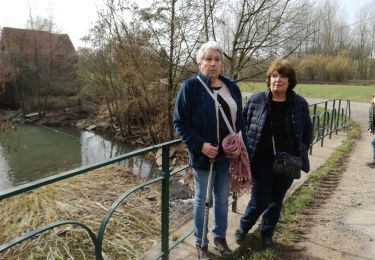
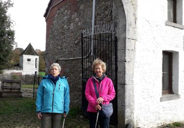
Randonnée Marche de 4,9 km à découvrir à Wallonie, Hainaut, Thuin. Cette randonnée est proposée par Maison du Tourisme du Val de Sambre et de Thudinie.
Description
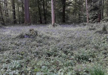
Au sein d'un des plus beaux villages de Wallonie, Ragnies.
Points d'intérêt
Localisation
Pays :
Belgique
Région :
Wallonie
Département/Province :
Hainaut
Commune :
Thuin
Localité :
Ragnies
Départ:(Dec)
Départ:(UTM)
591416 ; 5573694 (31U) N.
Commentaires
Randonnées à proximité
![Randonnée Marche Thuin - La balade du Bois des Waibes. - Photo](https://media.geolcdn.com/t/375/260/ext.jpg?maxdim=2&url=https%3A%2F%2Fservices.sitytrail.com%2FGeolivesWS%2FDownloadMedia.ashx%3FTrailID%3D846785%26Media%3D2a15c231-0cbe-4107-9b4e-b0ca15c25a1f.jpg)
![Marche Marche](https://static1.geolcdn.com/sitytour/trail-icons/101.png)
La balade du Bois des Waibes.
Marche
Facile
(4)
Thuin,
Wallonie,
Hainaut,
Belgique
![](/images/other/stat-length.png)
9,9 km | 12 km-effort
2h 41min
![](https://static1.geolcdn.com/siteimages/upload/files/16400158638029165_repeat_loop_refresh_sync_direction_icon.png)
Oui
![Randonnée Marche Thuin - RB-Ha-08 - Thuin - Via allongement - Photo](https://media.geolcdn.com/t/375/260/ext.jpg?maxdim=2&url=https%3A%2F%2Fservices.sitytrail.com%2FGeolivesWS%2FDownloadMedia.ashx%3FTrailID%3D218762%26Media%3D7e0b1de5-2210-4f38-aa84-2fca8ae33ab8.jpg)
![Marche Marche](https://static1.geolcdn.com/sitytour/trail-icons/101.png)
RB-Ha-08 - Thuin - Via allongement
Marche
Très difficile
(2)
Thuin,
Wallonie,
Hainaut,
Belgique
![](/images/other/stat-length.png)
25 km | 32 km-effort
7h 12min
![](https://static1.geolcdn.com/siteimages/upload/files/16400158638029165_repeat_loop_refresh_sync_direction_icon.png)
Oui
![Randonnée Marche Thuin - RB-Ha-08 - Thuin - Photo](https://media.geolcdn.com/t/375/260/ext.jpg?maxdim=2&url=https%3A%2F%2Fservices.sitytrail.com%2FGeolivesWS%2FDownloadMedia.ashx%3FTrailID%3D179601%26Media%3D33d5cfdf-1096-4ca0-9209-00c5bbfd32f4.jpg)
![Marche Marche](https://static1.geolcdn.com/sitytour/trail-icons/101.png)
RB-Ha-08 - Thuin
Marche
Très difficile
(2)
Thuin,
Wallonie,
Hainaut,
Belgique
![](/images/other/stat-length.png)
22 km | 28 km-effort
6h 26min
![](https://static1.geolcdn.com/siteimages/upload/files/16400158638029165_repeat_loop_refresh_sync_direction_icon.png)
Oui
![Randonnée Marche Thuin - Thuin - De la Ville Haute à la Ville Basse - Photo](https://media.geolcdn.com/t/375/260/ext.jpg?maxdim=2&url=https%3A%2F%2Fservices.sitytrail.com%2FGeolivesWS%2FDownloadMedia.ashx%3FTrailID%3D96827%26Media%3Da38cc2d0-85a8-4251-9b00-ce6dea30fa93.JPG)
![Marche Marche](https://static1.geolcdn.com/sitytour/trail-icons/101.png)
Thuin - De la Ville Haute à la Ville Basse
Marche
Facile
(4)
Thuin,
Wallonie,
Hainaut,
Belgique
![](/images/other/stat-length.png)
4,5 km | 6,6 km-effort
1h 20min
![](https://static1.geolcdn.com/siteimages/upload/files/16400158638029165_repeat_loop_refresh_sync_direction_icon.png)
Oui
![Randonnée Marche Thuin - Ragnies - Photo](https://media.geolcdn.com/t/375/260/8ab2079a-6e03-4639-b2a2-057277a8cea4.jpg&format=jpg&maxdim=2)
![Marche Marche](https://static1.geolcdn.com/sitytour/trail-icons/101.png)
Ragnies
Marche
Très facile
(3)
Thuin,
Wallonie,
Hainaut,
Belgique
![](/images/other/stat-length.png)
6,6 km | 7,3 km-effort
1h 14min
![](https://static1.geolcdn.com/siteimages/upload/files/16400158638029165_repeat_loop_refresh_sync_direction_icon.png)
Oui
![Randonnée Marche Thuin - BIESME S THUIN - Photo](https://media.geolcdn.com/t/375/260/01557e7b-332e-431e-aaea-10ee42a38f9e.jpg&format=jpg&maxdim=2)
![Marche Marche](https://static1.geolcdn.com/sitytour/trail-icons/101.png)
BIESME S THUIN
Marche
Très facile
(1)
Thuin,
Wallonie,
Hainaut,
Belgique
![](/images/other/stat-length.png)
5,4 km | 6,6 km-effort
1h 34min
![](https://static1.geolcdn.com/siteimages/upload/files/16400158638029165_repeat_loop_refresh_sync_direction_icon.png)
Oui
![Randonnée Marche Beaumont - stree . église - Photo](https://media.geolcdn.com/t/375/260/fe3ff867-c8be-47c7-ad46-8772d5f9dd91.jpg&format=jpg&maxdim=2)
![Marche Marche](https://static1.geolcdn.com/sitytour/trail-icons/101.png)
stree . église
Marche
Facile
(1)
Beaumont,
Wallonie,
Hainaut,
Belgique
![](/images/other/stat-length.png)
6 km | 6,7 km-effort
1h 41min
![](https://static1.geolcdn.com/siteimages/upload/files/16400158638029165_repeat_loop_refresh_sync_direction_icon.png)
Oui
![Randonnée Marche Thuin - Balade à Thuillies - Photo](https://media.geolcdn.com/t/375/260/ext.jpg?maxdim=2&url=https%3A%2F%2Fstatic1.geolcdn.com%2Fsiteimages%2Fupload%2Ffiles%2F1553511878bg_sport_marche.png)
![Marche Marche](https://static1.geolcdn.com/sitytour/trail-icons/101.png)
Balade à Thuillies
Marche
Facile
(3)
Thuin,
Wallonie,
Hainaut,
Belgique
![](/images/other/stat-length.png)
5,2 km | 5,6 km-effort
1h 15min
![](https://static1.geolcdn.com/siteimages/upload/files/16400158638029165_repeat_loop_refresh_sync_direction_icon.png)
Oui
![Randonnée Marche Lobbes - La promenade héroique - Photo](https://media.geolcdn.com/t/375/260/ext.jpg?maxdim=2&url=https%3A%2F%2Fstatic1.geolcdn.com%2Fsiteimages%2Fupload%2Ffiles%2F1553511878bg_sport_marche.png)
![Marche Marche](https://static1.geolcdn.com/sitytour/trail-icons/101.png)
La promenade héroique
Marche
Très facile
(2)
Lobbes,
Wallonie,
Hainaut,
Belgique
![](/images/other/stat-length.png)
4,9 km | 6,2 km-effort
1h 18min
![](https://static1.geolcdn.com/siteimages/upload/files/16400158638029165_repeat_loop_refresh_sync_direction_icon.png)
Oui