![](/images/other/stat-length.png)
![Randonnée V.T.T. Giromagny - Giromagny - Ballon d'Alsace et halte à la ferme du Grand Langenberg - Photo](https://media.geolcdn.com/t/1900/400/ext.pjpeg?maxdim=2&url=https%3A%2F%2Fstatic1.geolcdn.com%2Fsiteimages%2Fupload%2Ffiles%2F1524743154velo.jpg)
Giromagny - Ballon d'Alsace et halte à la ferme du Grand Langenberg
Bart2015
Utilisateur
![Longueur](/images/other/stat-length.png)
![Altitude max](https://static1.geolcdn.com/siteimages/upload/files/1508320355ic_sort_altitude_max_24dp.png)
![Dénivelé positif](https://static1.geolcdn.com/siteimages/upload/files/1508320355ic_sort_den_pos_24dp.png)
![Km-Effort](/images/other/stat-length.png)
![Altitude min](https://static1.geolcdn.com/siteimages/upload/files/1508320355ic_sort_altitude_min_24dp.png)
![Dénivelé négatif](https://static1.geolcdn.com/siteimages/upload/files/1508320355ic_sort_den_neg_24dp.png)
![Boucle](https://static1.geolcdn.com/siteimages/upload/files/16400158638029165_repeat_loop_refresh_sync_direction_icon.png)
![V.T.T.](https://static1.geolcdn.com/sitytour/trail-icons/202.png)
4h17
Difficulté : Très difficile
![Scannez ce code QR pour ouvrir la randonnée dans l'application SityTrail](https://capi.geolives.com/qq0zvz2zws4bq2lad0pu/sitytour/trails/3703857/qr.png?size=200)
Application GPS de randonnée GRATUITE
À propos
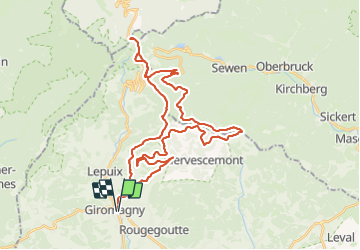
Randonnée V.T.T. de 43 km à découvrir à Bourgogne-Franche-Comté, Territoire-de-Belfort, Giromagny. Cette randonnée est proposée par Bart2015.
Description
Rando VTT électrique au départ du parking de Giromagny. Montée par le Col du Hirtzlach puis du Lossberg. Halte à la ferme auberge du Grand Langenberg (ne pas oublier de réserver). Montée au Ballon d'Alsace puis retour par la Gentiane, le Wissgrut, le Col du Chantoiseau et le Château Ritter.
Bonne rando ...
Localisation
Commentaires
Randonnées à proximité
![Randonnée Marche Auxelles-Haut - Rando-planche belles filles par auxelle haut - Photo](https://media.geolcdn.com/t/375/260/ext.jpg?maxdim=2&url=https%3A%2F%2Fservices.sitytrail.com%2FGeolivesWS%2FDownloadMedia.ashx%3FTrailID%3D305224%26Media%3D10d34718-818e-4b54-8a0e-bb1d508617db.JPG)
![Marche Marche](https://static1.geolcdn.com/sitytour/trail-icons/101.png)
Marche
![](/images/other/stat-length.png)
![](https://static1.geolcdn.com/siteimages/upload/files/16400158638029165_repeat_loop_refresh_sync_direction_icon.png)
![Randonnée Marche Lepuix - Le Tremontkopf - Photo](https://media.geolcdn.com/t/375/260/ext.jpg?maxdim=2&url=https%3A%2F%2Fservices.sitytrail.com%2FGeolivesWS%2FDownloadMedia.ashx%3FTrailID%3D109649%26Media%3D4290_1.jpg)
![Marche Marche](https://static1.geolcdn.com/sitytour/trail-icons/101.png)
Marche
![](/images/other/stat-length.png)
![](https://static1.geolcdn.com/siteimages/upload/files/16400158638029165_repeat_loop_refresh_sync_direction_icon.png)
![Randonnée Marche Plancher-les-Mines - 2019-08-07 Balade Plancher des belles filles - Photo](https://media.geolcdn.com/t/375/260/66a371f6-1837-4f48-9b52-0abd1c8fe413.jpg&format=jpg&maxdim=2)
![Marche Marche](https://static1.geolcdn.com/sitytour/trail-icons/101.png)
Marche
![](/images/other/stat-length.png)
![](https://static1.geolcdn.com/siteimages/upload/files/16400158638029165_repeat_loop_refresh_sync_direction_icon.png)
![Randonnée Marche Lepuix - Malvaux - Ballon d'Alsace - La Gentiane - Photo](https://media.geolcdn.com/t/375/260/79578682-d0f3-4956-a014-9b78edebdf9a.jpg&format=jpg&maxdim=2)
![Marche Marche](https://static1.geolcdn.com/sitytour/trail-icons/101.png)
Marche
![](/images/other/stat-length.png)
![](https://static1.geolcdn.com/siteimages/upload/files/16400158638029165_repeat_loop_refresh_sync_direction_icon.png)
![Randonnée Marche Lepuix - Malvaux - Ballon d'Alsace (15/12 au 15/7) - Photo](https://media.geolcdn.com/t/375/260/8b5b8e46-b065-4d76-880f-ae90ac7502e3.jpg&format=jpg&maxdim=2)
![Marche Marche](https://static1.geolcdn.com/sitytour/trail-icons/101.png)
Marche
![](/images/other/stat-length.png)
![](https://static1.geolcdn.com/siteimages/upload/files/16400158638029165_repeat_loop_refresh_sync_direction_icon.png)
![Randonnée Marche Lepuix - Saut de la Truite - cascade du Rummel - Etang du Petit-Haut - Ballon d'alsace - Photo](https://media.geolcdn.com/t/375/260/86bdad0e-488c-4de2-8052-bbc2db6811d9.jpg&format=jpg&maxdim=2)
![Marche Marche](https://static1.geolcdn.com/sitytour/trail-icons/101.png)
Marche
![](/images/other/stat-length.png)
![](https://static1.geolcdn.com/siteimages/upload/files/16400158638029165_repeat_loop_refresh_sync_direction_icon.png)
![Randonnée Marche Plancher-les-Mines - Cascades de la Goutte des Saules - Belvédère - Grotte St Antoine - Photo](https://media.geolcdn.com/t/375/260/675d2d72-2ae5-41bd-abbb-b7f938827506.jpg&format=jpg&maxdim=2)
![Marche Marche](https://static1.geolcdn.com/sitytour/trail-icons/101.png)
Marche
![](/images/other/stat-length.png)
![](https://static1.geolcdn.com/siteimages/upload/files/16400158638029165_repeat_loop_refresh_sync_direction_icon.png)
![Randonnée Marche Plancher-les-Mines - 130722 - La planche des belles - au pieds du Ballons d’Alsaces - Photo](https://media.geolcdn.com/t/375/260/63970d70-3d7a-4dbb-88a1-8a2718140e81.jpg&format=jpg&maxdim=2)
![Marche Marche](https://static1.geolcdn.com/sitytour/trail-icons/101.png)
Marche
![](/images/other/stat-length.png)
![](https://static1.geolcdn.com/siteimages/upload/files/16400158638029165_repeat_loop_refresh_sync_direction_icon.png)
![Randonnée Marche Lepuix - Lepuix - Etang des Belles Filles - Planche des Belles Filles - Photo](https://media.geolcdn.com/t/375/260/825a9563-3383-4652-916e-ce53d52edcdc.jpg&format=jpg&maxdim=2)
![Marche Marche](https://static1.geolcdn.com/sitytour/trail-icons/101.png)
Marche
![](/images/other/stat-length.png)
![](https://static1.geolcdn.com/siteimages/upload/files/16400158638029165_repeat_loop_refresh_sync_direction_icon.png)