![](/images/other/stat-length.png)
Pain de Sucre 400m+ depuis le col Agnel
ericberlin
Utilisateur
![Longueur](/images/other/stat-length.png)
Longueur
4,2 km
![Altitude max](https://static1.geolcdn.com/siteimages/upload/files/1508320355ic_sort_altitude_max_24dp.png)
Altitude max
3145 m
![Dénivelé positif](https://static1.geolcdn.com/siteimages/upload/files/1508320355ic_sort_den_pos_24dp.png)
Dénivelé positif
400 m
![Km-Effort](/images/other/stat-length.png)
Km-Effort
9,6 km
![Altitude min](https://static1.geolcdn.com/siteimages/upload/files/1508320355ic_sort_altitude_min_24dp.png)
Altitude min
2738 m
![Dénivelé négatif](https://static1.geolcdn.com/siteimages/upload/files/1508320355ic_sort_den_neg_24dp.png)
Dénivelé négatif
400 m
![Boucle](https://static1.geolcdn.com/siteimages/upload/files/16400158638029165_repeat_loop_refresh_sync_direction_icon.png)
Boucle
Oui
Date de création :
2023-06-14 14:55:56.636
Dernière modification :
2023-06-14 15:04:00.457
![Marche](https://static1.geolcdn.com/sitytour/trail-icons/101.png)
2h10
Difficulté : Moyen
![Scannez ce code QR pour ouvrir la randonnée dans l'application SityTrail](https://capi.geolives.com/qq0zvz2zws4bq2lad0pu/sitytour/trails/3699253/qr.png?size=200)
Application GPS de randonnée GRATUITE
À propos
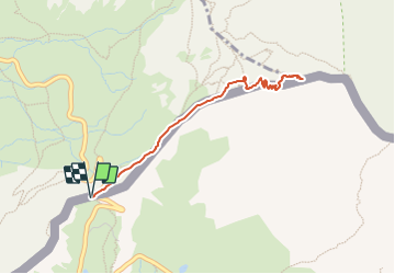
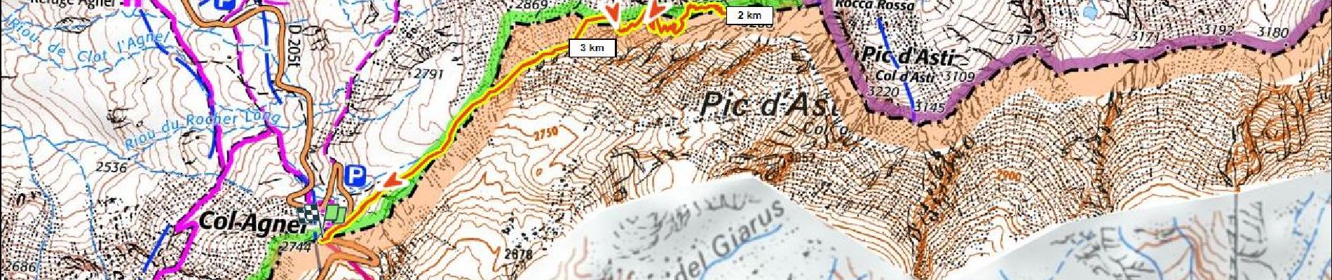
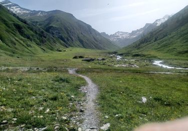
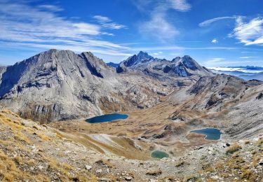
Randonnée Marche de 4,2 km à découvrir à Piémont, Coni, Pontechianale. Cette randonnée est proposée par ericberlin.
Description
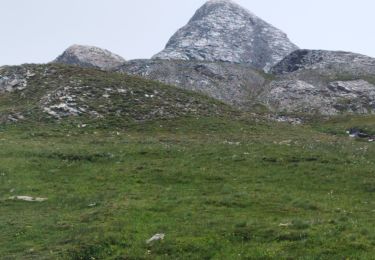
Un "3000" facile mais attention aux conditions de haute montagne, neige au début de l'été, orages fréquents après 11h.
Un panorama à decouvrir au lever du soleil.
Refuge Agnel à proximité du départ
Localisation
Pays :
Italie
Région :
Piémont
Département/Province :
Coni
Commune :
Pontechianale
Localité :
Unknown
Départ:(Dec)
Départ:(UTM)
339864 ; 4949812 (32T) N.
Commentaires
Randonnées à proximité
![Randonnée Marche Saint-Véran - Lac de la Blanche, lacs blanchet et pic de Caramantran - Photo](https://media.geolcdn.com/t/375/260/ext.jpg?maxdim=2&url=https%3A%2F%2Fservices.sitytrail.com%2FGeolivesWS%2FDownloadMedia.ashx%3FTrailID%3D596077%26Media%3Dfix__20160710142025.jpg)
![Marche Marche](https://static1.geolcdn.com/sitytour/trail-icons/101.png)
Lac de la Blanche, lacs blanchet et pic de Caramantran
Marche
Moyen
(2)
Saint-Véran,
Provence-Alpes-Côte d'Azur,
Hautes-Alpes,
France
![](/images/other/stat-length.png)
13,1 km | 23 km-effort
6h 12min
![](https://static1.geolcdn.com/siteimages/upload/files/16400158638029165_repeat_loop_refresh_sync_direction_icon.png)
Oui
![Randonnée Marche Pontechianale - ITALIE BELLINO CHIANALE . TOUR DU PAIN DU SUCRE . AR. O - Photo](https://media.geolcdn.com/t/375/260/605ee47c-e413-41ea-82a5-10806d48b77c.jpg&format=jpg&maxdim=2)
![Marche Marche](https://static1.geolcdn.com/sitytour/trail-icons/101.png)
ITALIE BELLINO CHIANALE . TOUR DU PAIN DU SUCRE . AR. O
Marche
Moyen
Pontechianale,
Piémont,
Coni,
Italie
![](/images/other/stat-length.png)
7,7 km | 11,3 km-effort
2h 36min
![](https://static1.geolcdn.com/siteimages/upload/files/16400158638029165_repeat_loop_refresh_sync_direction_icon.png)
Oui
![Randonnée Marche Molines-en-Queyras - le tour du Pain de Sucre - Photo](https://media.geolcdn.com/t/375/260/ext.jpg?maxdim=2&url=https%3A%2F%2Fservices.sitytrail.com%2FGeolivesWS%2FDownloadMedia.ashx%3FTrailID%3D820382%26Media%3Dfix__20170830144825.jpg)
![Marche Marche](https://static1.geolcdn.com/sitytour/trail-icons/101.png)
le tour du Pain de Sucre
Marche
Difficile
Molines-en-Queyras,
Provence-Alpes-Côte d'Azur,
Hautes-Alpes,
France
![](/images/other/stat-length.png)
8,1 km | 16 km-effort
4h 57min
![](https://static1.geolcdn.com/siteimages/upload/files/16400158638029165_repeat_loop_refresh_sync_direction_icon.png)
Oui
![Randonnée Marche Saint-Véran - Pic de Caramantran - Photo](https://media.geolcdn.com/t/375/260/ext.jpg?maxdim=2&url=https%3A%2F%2Fservices.sitytrail.com%2FGeolivesWS%2FDownloadMedia.ashx%3FTrailID%3D629317%26Media%3D93967439-727d-490c-bf0f-c5937248e7c8.jpg)
![Marche Marche](https://static1.geolcdn.com/sitytour/trail-icons/101.png)
Pic de Caramantran
Marche
Très difficile
Saint-Véran,
Provence-Alpes-Côte d'Azur,
Hautes-Alpes,
France
![](/images/other/stat-length.png)
12 km | 23 km-effort
4h 41min
![](https://static1.geolcdn.com/siteimages/upload/files/16400158638029165_repeat_loop_refresh_sync_direction_icon.png)
Oui
![Randonnée Marche Molines-en-Queyras - Lacs Foréant, Egorgéou, Baricle et de l'Eychassier - Photo](https://media.geolcdn.com/t/375/260/ext.jpg?maxdim=2&url=https%3A%2F%2Fservices.sitytrail.com%2FGeolivesWS%2FDownloadMedia.ashx%3FTrailID%3D597581%26Media%3Dfix__20160713160454.jpg)
![Marche Marche](https://static1.geolcdn.com/sitytour/trail-icons/101.png)
Lacs Foréant, Egorgéou, Baricle et de l'Eychassier
Marche
Moyen
Molines-en-Queyras,
Provence-Alpes-Côte d'Azur,
Hautes-Alpes,
France
![](/images/other/stat-length.png)
13,8 km | 24 km-effort
6h 20min
![](https://static1.geolcdn.com/siteimages/upload/files/16400158638029165_repeat_loop_refresh_sync_direction_icon.png)
Oui
![Randonnée Marche Molines-en-Queyras - le pain de sucre - Photo](https://media.geolcdn.com/t/375/260/ext.jpg?maxdim=2&url=https%3A%2F%2Fservices.sitytrail.com%2FGeolivesWS%2FDownloadMedia.ashx%3FTrailID%3D444362%26Media%3Dfix__20150712140232.jpg)
![Marche Marche](https://static1.geolcdn.com/sitytour/trail-icons/101.png)
le pain de sucre
Marche
Difficile
(1)
Molines-en-Queyras,
Provence-Alpes-Côte d'Azur,
Hautes-Alpes,
France
![](/images/other/stat-length.png)
4,5 km | 10,1 km-effort
4h 39min
![](https://static1.geolcdn.com/siteimages/upload/files/16400158638029165_repeat_loop_refresh_sync_direction_icon.png)
Oui
![Randonnée Marche Pontechianale - pain de sucre circuit - Photo](https://media.geolcdn.com/t/375/260/765c798f-47ae-4e08-a9cf-50bd35561578.jpg&format=jpg&maxdim=2)
![Marche Marche](https://static1.geolcdn.com/sitytour/trail-icons/101.png)
pain de sucre circuit
Marche
Moyen
Pontechianale,
Piémont,
Coni,
Italie
![](/images/other/stat-length.png)
5,9 km | 11,9 km-effort
2h 12min
![](https://static1.geolcdn.com/siteimages/upload/files/16400158638029165_repeat_loop_refresh_sync_direction_icon.png)
Non
![Randonnée Marche Molines-en-Queyras - Pic Foréant et Col d'Asti - Photo](https://media.geolcdn.com/t/375/260/0a0f75bf-b7eb-4c17-be04-8e1330cfc2d9.jpg&format=jpg&maxdim=2)
![Marche Marche](https://static1.geolcdn.com/sitytour/trail-icons/101.png)
Pic Foréant et Col d'Asti
Marche
Très difficile
Molines-en-Queyras,
Provence-Alpes-Côte d'Azur,
Hautes-Alpes,
France
![](/images/other/stat-length.png)
11,8 km | 24 km-effort
7h 14min
![](https://static1.geolcdn.com/siteimages/upload/files/16400158638029165_repeat_loop_refresh_sync_direction_icon.png)
Non
![Randonnée Marche Molines-en-Queyras - 05-Pain-de-sucre-6.5km-525m-aout21 - Photo](https://media.geolcdn.com/t/375/260/7e381716-a2f4-4b1d-8463-85a8f85532fe.jpg&format=jpg&maxdim=2)
![Marche Marche](https://static1.geolcdn.com/sitytour/trail-icons/101.png)
05-Pain-de-sucre-6.5km-525m-aout21
Marche
Moyen
Molines-en-Queyras,
Provence-Alpes-Côte d'Azur,
Hautes-Alpes,
France
![](/images/other/stat-length.png)
6,5 km | 13,5 km-effort
4h 14min
![](https://static1.geolcdn.com/siteimages/upload/files/16400158638029165_repeat_loop_refresh_sync_direction_icon.png)
Oui