![](/images/other/stat-length.png)
![Randonnée Vélo de route Breitnau - Van Breitbach naar Schluchsee en terug - Photo](https://media.geolcdn.com/t/1900/400/ext.pjpeg?maxdim=2&url=https%3A%2F%2Fstatic1.geolcdn.com%2Fsiteimages%2Fupload%2Ffiles%2F1524743154velo.jpg)
Van Breitbach naar Schluchsee en terug
Theo Van Leeuwen
Utilisateur
![Longueur](/images/other/stat-length.png)
Longueur
47 km
![Altitude max](https://static1.geolcdn.com/siteimages/upload/files/1508320355ic_sort_altitude_max_24dp.png)
Altitude max
1035 m
![Dénivelé positif](https://static1.geolcdn.com/siteimages/upload/files/1508320355ic_sort_den_pos_24dp.png)
Dénivelé positif
893 m
![Km-Effort](/images/other/stat-length.png)
Km-Effort
59 km
![Altitude min](https://static1.geolcdn.com/siteimages/upload/files/1508320355ic_sort_altitude_min_24dp.png)
Altitude min
846 m
![Dénivelé négatif](https://static1.geolcdn.com/siteimages/upload/files/1508320355ic_sort_den_neg_24dp.png)
Dénivelé négatif
893 m
![Boucle](https://static1.geolcdn.com/siteimages/upload/files/16400158638029165_repeat_loop_refresh_sync_direction_icon.png)
Boucle
Oui
Date de création :
2023-06-14 08:33:15.192
Dernière modification :
2023-06-14 13:21:37.803
![Vélo de route](https://static1.geolcdn.com/sitytour/trail-icons/201.png)
4h00
Difficulté : Difficile
![Vélo électrique](https://static1.geolcdn.com/sitytour/trail-icons/205.png)
3h00
Difficulté : Moyen
![Scannez ce code QR pour ouvrir la randonnée dans l'application SityTrail](https://capi.geolives.com/qq0zvz2zws4bq2lad0pu/sitytour/trails/3699094/qr.png?size=200)
Application GPS de randonnée GRATUITE
À propos
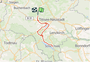
Randonnée Vélo de route de 47 km à découvrir à Bade-Wurtemberg, Arrondissement de Brisgau-Haute-Forêt-Noire, Breitnau. Cette randonnée est proposée par Theo Van Leeuwen.
Description
De fietstocht gaat van Breitbach via Titisee, Neustadt, naar de Schluchsee en weer terug.
Localisation
Pays :
Allemagne
Région :
Bade-Wurtemberg
Département/Province :
Arrondissement de Brisgau-Haute-Forêt-Noire
Commune :
Breitnau
Localité :
Unknown
Départ:(Dec)
Départ:(UTM)
432554 ; 5309082 (32T) N.
Commentaires
Randonnées à proximité
![Randonnée A pied St. Märgen - Panoramarundweg Thurner - Photo](https://media.geolcdn.com/t/375/260/ext.jpg?maxdim=2&url=https%3A%2F%2Fmedia.geolcdn.com%2Ff%2F777c224e-ce3e-40be-b098-98f52709fc0a.jpeg)
![A pied A pied](https://static1.geolcdn.com/sitytour/trail-icons/100.png)
Panoramarundweg Thurner
A pied
Facile
St. Märgen,
Bade-Wurtemberg,
Arrondissement de Brisgau-Haute-Forêt-Noire,
Allemagne
![](/images/other/stat-length.png)
3,6 km | 4,6 km-effort
1h 2min
![](https://static1.geolcdn.com/siteimages/upload/files/16400158638029165_repeat_loop_refresh_sync_direction_icon.png)
Non
![Randonnée Marche Hinterzarten - Hinterzarten - Mathisleweiher - Photo](https://media.geolcdn.com/t/375/260/ext.jpg?maxdim=2&url=https%3A%2F%2Fmedia.geolcdn.com%2Ff%2F40a753fc-39e1-4b12-8519-becb3ee7b5cd.jpg)
![Marche Marche](https://static1.geolcdn.com/sitytour/trail-icons/101.png)
Hinterzarten - Mathisleweiher
Marche
Moyen
Hinterzarten,
Bade-Wurtemberg,
Arrondissement de Brisgau-Haute-Forêt-Noire,
Allemagne
![](/images/other/stat-length.png)
6,7 km | 9,4 km-effort
2h 8min
![](https://static1.geolcdn.com/siteimages/upload/files/16400158638029165_repeat_loop_refresh_sync_direction_icon.png)
Oui
![Randonnée Marche Hinterzarten - Alsbach - Photo](https://media.geolcdn.com/t/375/260/ext.jpg?maxdim=2&url=https%3A%2F%2Fmedia.geolcdn.com%2Ff%2F303dc0ac-823f-477d-accd-2a7e3c188082.jpg)
![Marche Marche](https://static1.geolcdn.com/sitytour/trail-icons/101.png)
Alsbach
Marche
Très difficile
Hinterzarten,
Bade-Wurtemberg,
Arrondissement de Brisgau-Haute-Forêt-Noire,
Allemagne
![](/images/other/stat-length.png)
14,4 km | 20 km-effort
6h 10min
![](https://static1.geolcdn.com/siteimages/upload/files/16400158638029165_repeat_loop_refresh_sync_direction_icon.png)
Oui
![Randonnée Marche Hinterzarten - Hinterzarten - Titisee - Photo](https://media.geolcdn.com/t/375/260/ext.jpg?maxdim=2&url=https%3A%2F%2Fmedia.geolcdn.com%2Ff%2F8aee1643-27e5-448b-8138-942d06427fe7.jpg)
![Marche Marche](https://static1.geolcdn.com/sitytour/trail-icons/101.png)
Hinterzarten - Titisee
Marche
Difficile
Hinterzarten,
Bade-Wurtemberg,
Arrondissement de Brisgau-Haute-Forêt-Noire,
Allemagne
![](/images/other/stat-length.png)
13,5 km | 17,3 km-effort
3h 55min
![](https://static1.geolcdn.com/siteimages/upload/files/16400158638029165_repeat_loop_refresh_sync_direction_icon.png)
Oui
![Randonnée Marche Titisee-Neustadt - balade vers Saig - Photo](https://media.geolcdn.com/t/375/260/ext.jpg?maxdim=2&url=https%3A%2F%2Fmedia.geolcdn.com%2Ff%2F3cede852-3cc6-472a-b2ed-47d81e6aef8f.jpg)
![Marche Marche](https://static1.geolcdn.com/sitytour/trail-icons/101.png)
balade vers Saig
Marche
Moyen
Titisee-Neustadt,
Bade-Wurtemberg,
Arrondissement de Brisgau-Haute-Forêt-Noire,
Allemagne
![](/images/other/stat-length.png)
5,5 km | 8,6 km-effort
1h 45min
![](https://static1.geolcdn.com/siteimages/upload/files/16400158638029165_repeat_loop_refresh_sync_direction_icon.png)
Non
![Randonnée Marche Titisee-Neustadt - promenade autour du lac de Titisee, 31.10.22 - Photo](https://media.geolcdn.com/t/375/260/ext.jpg?maxdim=2&url=https%3A%2F%2Fmedia.geolcdn.com%2Ff%2Fceac7520-c20f-4691-993c-5f34b6a75138.jpg)
![Marche Marche](https://static1.geolcdn.com/sitytour/trail-icons/101.png)
promenade autour du lac de Titisee, 31.10.22
Marche
Facile
Titisee-Neustadt,
Bade-Wurtemberg,
Arrondissement de Brisgau-Haute-Forêt-Noire,
Allemagne
![](/images/other/stat-length.png)
4,2 km | 5,2 km-effort
1h 14min
![](https://static1.geolcdn.com/siteimages/upload/files/16400158638029165_repeat_loop_refresh_sync_direction_icon.png)
Non
![Randonnée A pied Titisee-Neustadt - Westweg Day 4 Titisee to Feldber Orl - Photo](https://media.geolcdn.com/t/375/260/ext.jpg?maxdim=2&url=https%3A%2F%2Fstatic1.geolcdn.com%2Fsiteimages%2Fupload%2Ffiles%2F1545311037marcheuse_200dpi.jpg)
![A pied A pied](https://static1.geolcdn.com/sitytour/trail-icons/100.png)
Westweg Day 4 Titisee to Feldber Orl
A pied
Moyen
Titisee-Neustadt,
Bade-Wurtemberg,
Arrondissement de Brisgau-Haute-Forêt-Noire,
Allemagne
![](/images/other/stat-length.png)
17,7 km | 27 km-effort
Inconnu
![](https://static1.geolcdn.com/siteimages/upload/files/16400158638029165_repeat_loop_refresh_sync_direction_icon.png)
Non
![Randonnée Marche Hinterzarten - Forêt Noire tracé 4 aout 2018 - Photo](https://media.geolcdn.com/t/375/260/ext.jpg?maxdim=2&url=https%3A%2F%2Fstatic1.geolcdn.com%2Fsiteimages%2Fupload%2Ffiles%2F1553511878bg_sport_marche.png)
![Marche Marche](https://static1.geolcdn.com/sitytour/trail-icons/101.png)
Forêt Noire tracé 4 aout 2018
Marche
Très facile
Hinterzarten,
Bade-Wurtemberg,
Arrondissement de Brisgau-Haute-Forêt-Noire,
Allemagne
![](/images/other/stat-length.png)
248 km | 279 km-effort
Inconnu
![](https://static1.geolcdn.com/siteimages/upload/files/16400158638029165_repeat_loop_refresh_sync_direction_icon.png)
Non
![Randonnée Vélo Hinterzarten - Forêt Noire tracé 1 aout 2018 - Photo](https://media.geolcdn.com/t/375/260/ext.jpg?maxdim=2&url=https%3A%2F%2Fstatic1.geolcdn.com%2Fsiteimages%2Fupload%2Ffiles%2F1524743154velo.jpg)
![Vélo Vélo](https://static1.geolcdn.com/sitytour/trail-icons/200.png)
Forêt Noire tracé 1 aout 2018
Vélo
Très facile
Hinterzarten,
Bade-Wurtemberg,
Arrondissement de Brisgau-Haute-Forêt-Noire,
Allemagne
![](/images/other/stat-length.png)
91 km | 104 km-effort
6h 1min
![](https://static1.geolcdn.com/siteimages/upload/files/16400158638029165_repeat_loop_refresh_sync_direction_icon.png)
Non