![](/images/other/stat-length.png)
![Randonnée Marche Binche - LEVAL-TRAHEGNIES _ Marche Fédérale _ HT _ 10/06/2023 - Photo](https://media.geolcdn.com/t/1900/400/ext.pjpeg?maxdim=2&url=https%3A%2F%2Fstatic1.geolcdn.com%2Fsiteimages%2Fupload%2Ffiles%2F1553511878bg_sport_marche.png)
LEVAL-TRAHEGNIES _ Marche Fédérale _ HT _ 10/06/2023
jeangulu
Utilisateur
![Longueur](/images/other/stat-length.png)
Longueur
21 km
![Altitude max](https://static1.geolcdn.com/siteimages/upload/files/1508320355ic_sort_altitude_max_24dp.png)
Altitude max
204 m
![Dénivelé positif](https://static1.geolcdn.com/siteimages/upload/files/1508320355ic_sort_den_pos_24dp.png)
Dénivelé positif
231 m
![Km-Effort](/images/other/stat-length.png)
Km-Effort
24 km
![Altitude min](https://static1.geolcdn.com/siteimages/upload/files/1508320355ic_sort_altitude_min_24dp.png)
Altitude min
86 m
![Dénivelé négatif](https://static1.geolcdn.com/siteimages/upload/files/1508320355ic_sort_den_neg_24dp.png)
Dénivelé négatif
230 m
![Boucle](https://static1.geolcdn.com/siteimages/upload/files/16400158638029165_repeat_loop_refresh_sync_direction_icon.png)
Boucle
Oui
Date de création :
2023-06-10 07:53:30.97
Dernière modification :
2023-06-10 15:33:45.218
![Marche](https://static1.geolcdn.com/sitytour/trail-icons/101.png)
4h38
Difficulté : Moyen
![Scannez ce code QR pour ouvrir la randonnée dans l'application SityTrail](https://capi.geolives.com/qq0zvz2zws4bq2lad0pu/sitytour/trails/3694186/qr.png?size=200)
Application GPS de randonnée GRATUITE
À propos
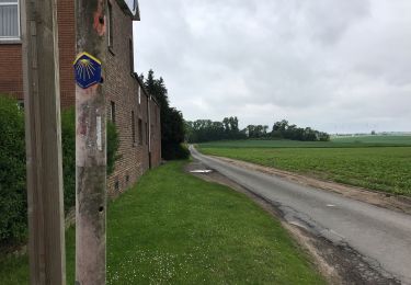
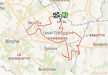
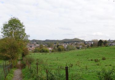
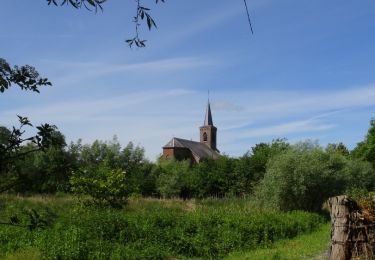
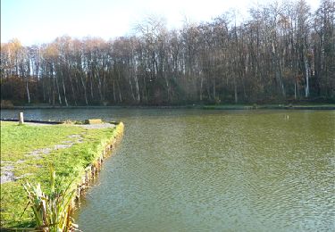
Randonnée Marche de 21 km à découvrir à Wallonie, Hainaut, Binche. Cette randonnée est proposée par jeangulu.
Description
Organisateur : HT 031 _ LES TATANES AILEES EPINOIS.
Marche des Bois.
Point de départ : Cercle <<L'Union >> _ Rue S.Allendé 208 ( Grand'Place ) _ 7134 - LEVAL-TRAHEGNIES.
Carte IGN : 46/6.
Remarque : Chaleur torride - dommage un seul contrôle sur le parcours des 20 kms
Localisation
Pays :
Belgique
Région :
Wallonie
Département/Province :
Hainaut
Commune :
Binche
Localité :
Unknown
Départ:(Dec)
Départ:(UTM)
586726 ; 5586538 (31U) N.
Commentaires
Randonnées à proximité
![Randonnée Marche Morlanwelz - Le circuit des 3 villages - Morlanwelz - Photo](https://media.geolcdn.com/t/375/260/ext.jpg?maxdim=2&url=https%3A%2F%2Fservices.sitytrail.com%2FGeolivesWS%2FDownloadMedia.ashx%3FTrailID%3D359319%26Media%3Dc0e82042-2414-44e3-b558-69c50177e9e8.JPG)
![Marche Marche](https://static1.geolcdn.com/sitytour/trail-icons/101.png)
Le circuit des 3 villages - Morlanwelz
Marche
Très facile
(4)
Morlanwelz,
Wallonie,
Hainaut,
Belgique
![](/images/other/stat-length.png)
7,9 km | 9,6 km-effort
2h 6min
![](https://static1.geolcdn.com/siteimages/upload/files/16400158638029165_repeat_loop_refresh_sync_direction_icon.png)
Oui
![Randonnée Marche Binche - Les marais de Buvrinnes - Photo](https://media.geolcdn.com/t/375/260/ext.jpg?maxdim=2&url=https%3A%2F%2Fservices.sitytrail.com%2FGeolivesWS%2FDownloadMedia.ashx%3FTrailID%3D308684%26Media%3Dc96914c7-aa42-4b0f-8d11-534a0221fc18.JPG)
![Marche Marche](https://static1.geolcdn.com/sitytour/trail-icons/101.png)
Les marais de Buvrinnes
Marche
Très facile
(2)
Binche,
Wallonie,
Hainaut,
Belgique
![](/images/other/stat-length.png)
4,2 km | 5 km-effort
1h 5min
![](https://static1.geolcdn.com/siteimages/upload/files/16400158638029165_repeat_loop_refresh_sync_direction_icon.png)
Oui
![Randonnée Marche Binche - De Leval-Trahegnies à Mont-Sainte-Aldegonde - Photo](https://media.geolcdn.com/t/375/260/ext.jpg?maxdim=2&url=https%3A%2F%2Fservices.sitytrail.com%2FGeolivesWS%2FDownloadMedia.ashx%3FTrailID%3D96104%26Media%3D21dc5c72-4ff2-4334-88b1-a5c37d1d86a8.JPG)
![Marche Marche](https://static1.geolcdn.com/sitytour/trail-icons/101.png)
De Leval-Trahegnies à Mont-Sainte-Aldegonde
Marche
Facile
(1)
Binche,
Wallonie,
Hainaut,
Belgique
![](/images/other/stat-length.png)
8,8 km | 10,8 km-effort
2h 20min
![](https://static1.geolcdn.com/siteimages/upload/files/16400158638029165_repeat_loop_refresh_sync_direction_icon.png)
Oui
![Randonnée Marche Anderlues - 20180205 rando - Photo](https://media.geolcdn.com/t/375/260/ext.jpg?maxdim=2&url=https%3A%2F%2Fservices.sitytrail.com%2FGeolivesWS%2FDownloadMedia.ashx%3FTrailID%3D917494%26Media%3Dfix__20180305143629.jpg)
![Marche Marche](https://static1.geolcdn.com/sitytour/trail-icons/101.png)
20180205 rando
Marche
Très facile
(1)
Anderlues,
Wallonie,
Hainaut,
Belgique
![](/images/other/stat-length.png)
3,4 km | 3,6 km-effort
27min
![](https://static1.geolcdn.com/siteimages/upload/files/16400158638029165_repeat_loop_refresh_sync_direction_icon.png)
Oui
![Randonnée Marche Binche - Balade à Binche - Photo](https://media.geolcdn.com/t/375/260/ext.jpg?maxdim=2&url=https%3A%2F%2Fstatic1.geolcdn.com%2Fsiteimages%2Fupload%2Ffiles%2F1553511878bg_sport_marche.png)
![Marche Marche](https://static1.geolcdn.com/sitytour/trail-icons/101.png)
Balade à Binche
Marche
Moyen
(4)
Binche,
Wallonie,
Hainaut,
Belgique
![](/images/other/stat-length.png)
17,9 km | 21 km-effort
4h 30min
![](https://static1.geolcdn.com/siteimages/upload/files/16400158638029165_repeat_loop_refresh_sync_direction_icon.png)
Oui
![Randonnée Marche nordique Morlanwelz - Mont Sainte Aldegonde 7km - Photo](https://media.geolcdn.com/t/375/260/ext.jpg?maxdim=2&url=https%3A%2F%2Fstatic1.geolcdn.com%2Fsiteimages%2Fupload%2Ffiles%2F1545311037marcheuse_200dpi.jpg)
![Marche nordique Marche nordique](https://static1.geolcdn.com/sitytour/trail-icons/102.png)
Mont Sainte Aldegonde 7km
Marche nordique
Facile
(1)
Morlanwelz,
Wallonie,
Hainaut,
Belgique
![](/images/other/stat-length.png)
7,1 km | 8,2 km-effort
1h 30min
![](https://static1.geolcdn.com/siteimages/upload/files/16400158638029165_repeat_loop_refresh_sync_direction_icon.png)
Oui
![Randonnée A pied Anderlues - Le Chemin de la Bourlette - Photo](https://media.geolcdn.com/t/375/260/ext.jpg?maxdim=2&url=https%3A%2F%2Fpivotmedia.tourismewallonie.be%2FOTH-A0-004C-1Y9Z%2FOTH-A0-004C-1Y9Z.jpg)
![A pied A pied](https://static1.geolcdn.com/sitytour/trail-icons/100.png)
Le Chemin de la Bourlette
A pied
Facile
(1)
Anderlues,
Wallonie,
Hainaut,
Belgique
![](/images/other/stat-length.png)
8,3 km | 10,3 km-effort
2h 19min
![](https://static1.geolcdn.com/siteimages/upload/files/16400158638029165_repeat_loop_refresh_sync_direction_icon.png)
Oui
![Randonnée Marche Binche - Autour du marais de Buvrinnes - Photo](https://media.geolcdn.com/t/375/260/ext.jpg?maxdim=2&url=https%3A%2F%2Fstatic1.geolcdn.com%2Fsiteimages%2Fupload%2Ffiles%2F1553511878bg_sport_marche.png)
![Marche Marche](https://static1.geolcdn.com/sitytour/trail-icons/101.png)
Autour du marais de Buvrinnes
Marche
Facile
(1)
Binche,
Wallonie,
Hainaut,
Belgique
![](/images/other/stat-length.png)
4,2 km | 5 km-effort
1h 8min
![](https://static1.geolcdn.com/siteimages/upload/files/16400158638029165_repeat_loop_refresh_sync_direction_icon.png)
Oui
![Randonnée Marche Binche - Binche 20 km - Photo](https://media.geolcdn.com/t/375/260/1841b57f-6493-467c-87bb-7bd139775c50.jpg&format=jpg&maxdim=2)
![Marche Marche](https://static1.geolcdn.com/sitytour/trail-icons/101.png)