Randonnée Marche Saint-Just-Saint-Rambert - Le vieux St Rambert - Photo
 gannet1
gannet1

Utilisateur

© OpenStreetMap contributors
Longueur
Longueur
6,6 km
Altitude max
Altitude max
395 m
Dénivelé positif
Dénivelé positif
37 m
Km-Effort
Km-Effort  
7,1 km
Altitude min
Altitude min
378 m
Dénivelé négatif
Dénivelé négatif
39 m
Boucle
Boucle
Oui
Date de création :
2014-12-18 00:00:00.0
Dernière modification :
2014-12-18 00:00:00.0

(0 Avis)

Marche
Marche
1h50
Difficulté : Inconnu

Scannez ce code QR pour ouvrir la randonnée dans l'application SityTrail

Application GPS de randonnée GRATUITE

Logo SityTrail SityTrail

IGN / Instituts géographiques

Télécharger SityTrail sur l'App Store Télécharger SityTrail sur Google Play

Logo SityTrail SityTrail World

Le monde est à vous

Télécharger SityTrail sur l'App Store Télécharger SityTrail sur Google Play Télécharger SityTrail sur Huawei AppGallery

À propos

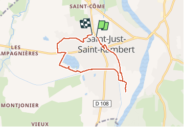
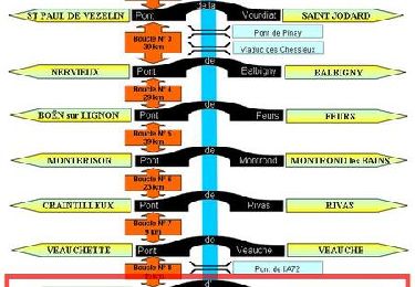
Randonnée Marche de 6,6 km à découvrir à Auvergne-Rhône-Alpes, Loire, Saint-Just-Saint-Rambert. Cette randonnée est proposée par gannet1.

Description

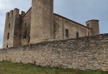
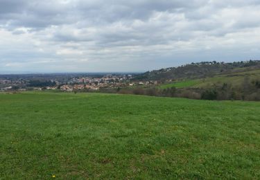
Eglise romane et vieilles maisons typiques du Forez. On longe une partie du canal du Forez construit pour l'irrigation de la plaine.
Testé par le groupe de marche du Forez

Profil altimétrique

Localisation

Pays :
France
Région :
Auvergne-Rhône-Alpes
Département/Province :
Loire
Commune :
Saint-Just-Saint-Rambert
Localité :
Saint-Rambert-sur-Loire
Départ:(Dec)
Départ:(UTM)
596934 ; 5039489 (31T) N.

Randonnées à proximité

Randonnée V.T.T. Saint-Just-Saint-Rambert - TBG - Photo
V.T.T.
ramsay

V.T.T.

Difficile
(2)
Saint-Just-Saint-Rambert, Auvergne-Rhône-Alpes, Loire, France
45 km | 59 km-effort
3h 49min
Oui
Randonnée Randonnée équestre Saint-Marcellin-en-Forez - rando chateau d'essalois - Photo
Randonnée équestre
quetschouille

Randonnée équestre

Difficile
Saint-Marcellin-en-Forez, Auvergne-Rhône-Alpes, Loire, France
26 km | 31 km-effort
4h 7min
Oui
Randonnée Marche Andrézieux-Bouthéon - autour de Boutheon  - Photo
Marche
Domdomii

Marche

Très facile
Andrézieux-Bouthéon, Auvergne-Rhône-Alpes, Loire, France
7,6 km | 8,7 km-effort
1h 46min
Oui
Randonnée Marche Saint-Just-Saint-Rambert - Barrage de Grangent - Photo
Marche
gannet1

Marche

Facile
(1)
Saint-Just-Saint-Rambert, Auvergne-Rhône-Alpes, Loire, France
10,2 km | 12,9 km-effort
5h 51min
Oui
Randonnée V.T.T. Andrézieux-Bouthéon - 14ème Envolée Verte (2014-VTT-60 km) - Andrézieux-Bouthéon - Photo
V.T.T.
tracegps

V.T.T.

Très difficile
Andrézieux-Bouthéon, Auvergne-Rhône-Alpes, Loire, France
59 km | 73 km-effort
4h 30min
Oui
Randonnée V.T.T. Saint-Just-Saint-Rambert - Du Barrage de Villerest au Barrage de Grangent en 10 boucles / Boucle N° 10 : Pont de Saint-Just-Saint-Rambert - Barrage de Grangent - Photo
V.T.T.
tracegps

V.T.T.

Très difficile
Saint-Just-Saint-Rambert, Auvergne-Rhône-Alpes, Loire, France
17,7 km | 23 km-effort
2h 30min
Oui
Randonnée V.T.T. Saint-Cyprien - Du Barrage de Villerest au Barrage de Grangent en 10 boucles / Boucle N° 09 : Pont d'Andrézieux - Pont de Saint-Just-Saint-Rambert - Photo
V.T.T.
tracegps

V.T.T.

Facile
Saint-Cyprien, Auvergne-Rhône-Alpes, Loire, France
8,2 km | 9 km-effort
1h 0min
Oui
Randonnée V.T.T. Sury-le-Comtal - Rallye VTT Suryquois - Sury le Comtal - Photo
V.T.T.
tracegps

V.T.T.

Très difficile
(1)
Sury-le-Comtal, Auvergne-Rhône-Alpes, Loire, France
43 km | 54 km-effort
4h 0min
Oui
Randonnée V.T.T. Andrézieux-Bouthéon - 13ème Envolée Verte (2013-VTT-46 km) - Andrézieux-Bouthéon - Photo
V.T.T.
tracegps

V.T.T.

Difficile
Andrézieux-Bouthéon, Auvergne-Rhône-Alpes, Loire, France
46 km | 56 km-effort
3h 30min
Oui


Fermer
Mes abonnements