Randonnée Marche Montcet - poncin - Photo
© OpenStreetMap contributors
Longueur
Longueur
13,7 km
Altitude max
Altitude max
248 m
Dénivelé positif
Dénivelé positif
129 m
Km-Effort
Km-Effort  
15,4 km
Altitude min
Altitude min
196 m
Dénivelé négatif
Dénivelé négatif
133 m
Boucle
Boucle
Oui
Date de création :
2023-06-05 07:35:36.848
Dernière modification :
2023-06-05 10:50:01.166

(0 Avis)

Marche
Marche
3h00
Difficulté : Difficile

Scannez ce code QR pour ouvrir la randonnée dans l'application SityTrail

Application GPS de randonnée GRATUITE

Logo SityTrail SityTrail

IGN / Instituts géographiques

Télécharger SityTrail sur l'App Store Télécharger SityTrail sur Google Play

Logo SityTrail SityTrail World

Le monde est à vous

Télécharger SityTrail sur l'App Store Télécharger SityTrail sur Google Play Télécharger SityTrail sur Huawei AppGallery

À propos

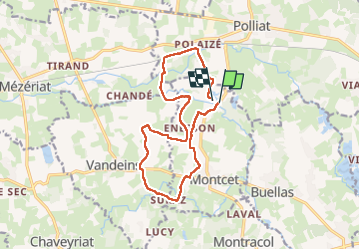
Randonnée Marche de 13,7 km à découvrir à Auvergne-Rhône-Alpes, Ain, Montcet. Cette randonnée est proposée par pascal.schiavinib@orange.fr.

Profil altimétrique

Localisation

Pays :
France
Région :
Auvergne-Rhône-Alpes
Département/Province :
Ain
Commune :
Montcet
Localité :
Unknown
Départ:(Dec)
Départ:(UTM)
663103 ; 5121861 (31T) N.

Randonnées à proximité

Randonnée Moteur Buellas - sortie courmangoux 07/2024 - Photo
Moteur
michelrongier

Moteur

Très facile
Buellas, Auvergne-Rhône-Alpes, Ain, France
71 km | 82 km-effort
Inconnu
Oui
Randonnée Marche Polliat - Polliat /les Vernays /champvent / chemin cure - Photo
Marche
btx

Marche

Très facile
Polliat, Auvergne-Rhône-Alpes, Ain, France
9 km | 9,9 km-effort
2h 12min
Oui
Randonnée Marche Polliat - btx01 - Photo
Marche
btx

Marche

Moyen
Polliat, Auvergne-Rhône-Alpes, Ain, France
11 km | 12,1 km-effort
2h 40min
Oui
Randonnée Moteur Buellas - Courmangoux le grand Brule - Photo
Moteur
BGO

Moteur

Très facile
Buellas, Auvergne-Rhône-Alpes, Ain, France
71 km | 82 km-effort
Inconnu
Oui
Randonnée Marche Saint-Rémy - 2023-12-09_Saint-Rémy-retracé- - Photo
Marche
montagnes

Marche

Moyen
Saint-Rémy, Auvergne-Rhône-Alpes, Ain, France
7,2 km | 8,4 km-effort
1h 54min
Oui
Randonnée Moteur Polliat - Foire Coligny départ Polliat - Photo
Moteur
BGO

Moteur

Très facile
Polliat, Auvergne-Rhône-Alpes, Ain, France
63 km | 72 km-effort
Inconnu
Oui
Randonnée Marche Buellas - buellas - Photo
Marche
montagnes

Marche

Moyen
Buellas, Auvergne-Rhône-Alpes, Ain, France
5 km | 6 km-effort
1h 45min
Non
Randonnée Marche Montracol - montracol - Photo
Marche
montagnes

Marche

Moyen
Montracol, Auvergne-Rhône-Alpes, Ain, France
7,2 km | 8 km-effort
1h 47min
Non
Randonnée Trail Polliat - vhhfgh - Photo
Trail
agonia

Trail

Très facile
Polliat, Auvergne-Rhône-Alpes, Ain, France
2,6 km | 2,8 km-effort
32min
Oui


Fermer
Mes abonnements