![](/images/other/stat-length.png)
![Randonnée Marche Ranrupt - 2023-06-04 Marche Col de Steige Tour du Climont - Photo](https://media.geolcdn.com/t/1900/400/935b7e44-7265-42c7-b6c2-a8897e52a122.jpg&format=pjpeg&maxdim=2)
2023-06-04 Marche Col de Steige Tour du Climont
holtzv
Utilisateur GUIDE
![Longueur](/images/other/stat-length.png)
Longueur
14,5 km
![Altitude max](https://static1.geolcdn.com/siteimages/upload/files/1508320355ic_sort_altitude_max_24dp.png)
Altitude max
964 m
![Dénivelé positif](https://static1.geolcdn.com/siteimages/upload/files/1508320355ic_sort_den_pos_24dp.png)
Dénivelé positif
715 m
![Km-Effort](/images/other/stat-length.png)
Km-Effort
24 km
![Altitude min](https://static1.geolcdn.com/siteimages/upload/files/1508320355ic_sort_altitude_min_24dp.png)
Altitude min
374 m
![Dénivelé négatif](https://static1.geolcdn.com/siteimages/upload/files/1508320355ic_sort_den_neg_24dp.png)
Dénivelé négatif
716 m
![Boucle](https://static1.geolcdn.com/siteimages/upload/files/16400158638029165_repeat_loop_refresh_sync_direction_icon.png)
Boucle
Oui
Date de création :
2023-06-04 08:51:26.915
Dernière modification :
2023-06-04 15:51:36.824
![Marche](https://static1.geolcdn.com/sitytour/trail-icons/101.png)
5h28
Difficulté : Facile
![Scannez ce code QR pour ouvrir la randonnée dans l'application SityTrail](https://capi.geolives.com/qq0zvz2zws4bq2lad0pu/sitytour/trails/3687101/qr.png?size=200)
Application GPS de randonnée GRATUITE
À propos
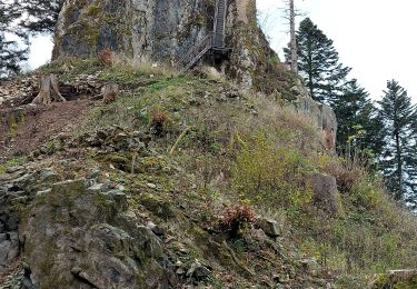
Randonnée Marche de 14,5 km à découvrir à Grand Est, Bas-Rhin, Ranrupt. Cette randonnée est proposée par holtzv.
Description
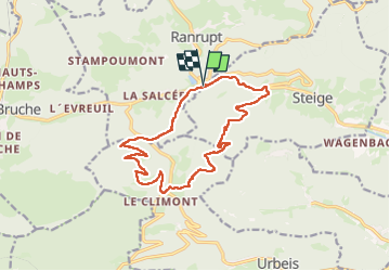
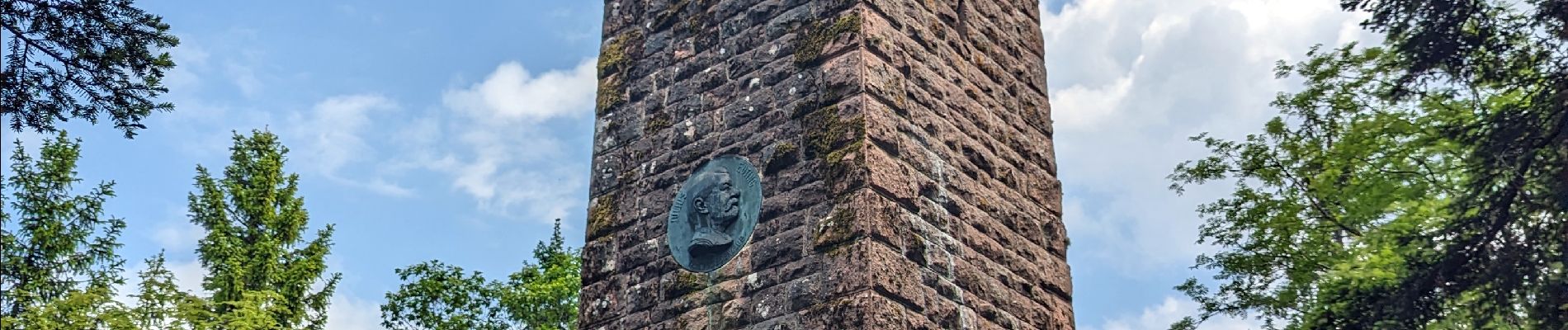
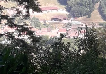
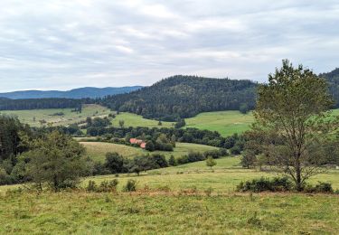
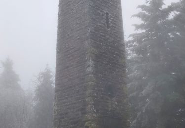
Boucle depuis le col de steige en passant par la tour du Climont (tour Julius), le grand sapin (coupé depuis 1958), cabane de la Hâle et le Mont
Localisation
Pays :
France
Région :
Grand Est
Département/Province :
Bas-Rhin
Commune :
Ranrupt
Localité :
Unknown
Départ:(Dec)
Départ:(UTM)
366725 ; 5358269 (32U) N.
Commentaires
Randonnées à proximité
![Randonnée Marche Steige - Steige blanc - Photo](https://media.geolcdn.com/t/375/260/3138d5a8-8f43-46fd-9a0c-b8aa1ff2972d.jpg&format=jpg&maxdim=2)
![Marche Marche](https://static1.geolcdn.com/sitytour/trail-icons/101.png)
Steige blanc
Marche
Moyen
(1)
Steige,
Grand Est,
Bas-Rhin,
France
![](/images/other/stat-length.png)
7,8 km | 12,6 km-effort
2h 7min
![](https://static1.geolcdn.com/siteimages/upload/files/16400158638029165_repeat_loop_refresh_sync_direction_icon.png)
Oui
![Randonnée Randonnée équestre Bourg-Bruche - 2023-09-16 Picnic CVA Climont Bourg Bruche - Photo](https://media.geolcdn.com/t/375/260/e3b3477a-361e-4f3c-9903-89043f8145ea.jpg&format=jpg&maxdim=2)
![Randonnée équestre Randonnée équestre](https://static1.geolcdn.com/sitytour/trail-icons/301.png)
2023-09-16 Picnic CVA Climont Bourg Bruche
Randonnée équestre
Moyen
Bourg-Bruche,
Grand Est,
Bas-Rhin,
France
![](/images/other/stat-length.png)
27 km | 39 km-effort
5h 11min
![](https://static1.geolcdn.com/siteimages/upload/files/16400158638029165_repeat_loop_refresh_sync_direction_icon.png)
Oui
![Randonnée Marche Ranrupt - 2018-12-30 Marche Climont Voyemont - Photo](https://media.geolcdn.com/t/375/260/55e3f2c1-2c0e-4070-b418-3c553de20538.jpg&format=jpg&maxdim=2)
![Marche Marche](https://static1.geolcdn.com/sitytour/trail-icons/101.png)
2018-12-30 Marche Climont Voyemont
Marche
Très facile
Ranrupt,
Grand Est,
Bas-Rhin,
France
![](/images/other/stat-length.png)
22 km | 33 km-effort
7h 21min
![](https://static1.geolcdn.com/siteimages/upload/files/16400158638029165_repeat_loop_refresh_sync_direction_icon.png)
Oui
![Randonnée Randonnée équestre Belmont - Circuit VC Belmont - Le Climont - Photo](https://media.geolcdn.com/t/375/260/a1198139-b874-4847-adb3-efd42fb36195.jpg&format=jpg&maxdim=2)
![Randonnée équestre Randonnée équestre](https://static1.geolcdn.com/sitytour/trail-icons/301.png)
Circuit VC Belmont - Le Climont
Randonnée équestre
Moyen
Belmont,
Grand Est,
Bas-Rhin,
France
![](/images/other/stat-length.png)
23 km | 33 km-effort
4h 20min
![](https://static1.geolcdn.com/siteimages/upload/files/16400158638029165_repeat_loop_refresh_sync_direction_icon.png)
Non
![Randonnée Randonnée équestre Belmont - Circuit VC Serva - Belmont - Photo](https://media.geolcdn.com/t/375/260/1588be67-92f1-44c9-a365-dcd95e3feb13.jpg&format=jpg&maxdim=2)
![Randonnée équestre Randonnée équestre](https://static1.geolcdn.com/sitytour/trail-icons/301.png)
Circuit VC Serva - Belmont
Randonnée équestre
Moyen
Belmont,
Grand Est,
Bas-Rhin,
France
![](/images/other/stat-length.png)
16,2 km | 22 km-effort
2h 50min
![](https://static1.geolcdn.com/siteimages/upload/files/16400158638029165_repeat_loop_refresh_sync_direction_icon.png)
Non
![Randonnée Marche Bellefosse - Col de la Charbonnière - château de la Roche - Bellefosse - Belmont - Photo](https://media.geolcdn.com/t/375/260/24310c6f-c7f0-4534-8ba0-5207981b0c8c.jpg&format=jpg&maxdim=2)
![Marche Marche](https://static1.geolcdn.com/sitytour/trail-icons/101.png)
Col de la Charbonnière - château de la Roche - Bellefosse - Belmont
Marche
Très difficile
Bellefosse,
Grand Est,
Bas-Rhin,
France
![](/images/other/stat-length.png)
15,7 km | 24 km-effort
5h 27min
![](https://static1.geolcdn.com/siteimages/upload/files/16400158638029165_repeat_loop_refresh_sync_direction_icon.png)
Oui
![Randonnée Raquettes à neige Belmont - cascade de la serva - Photo](https://media.geolcdn.com/t/375/260/9e54cbbc-1369-400d-91a3-b8884cb0f35c.jpg&format=jpg&maxdim=2)
![Raquettes à neige Raquettes à neige](https://static1.geolcdn.com/sitytour/trail-icons/504.png)
cascade de la serva
Raquettes à neige
Moyen
Belmont,
Grand Est,
Bas-Rhin,
France
![](/images/other/stat-length.png)
7,1 km | 10,8 km-effort
3h 41min
![](https://static1.geolcdn.com/siteimages/upload/files/16400158638029165_repeat_loop_refresh_sync_direction_icon.png)
Oui
![Randonnée Marche Breitenbach - Col de la Charbonnière -Château de la Roche - Photo](https://media.geolcdn.com/t/375/260/2697d717-0d30-43cc-9812-47c6d2c21947.jpg&format=jpg&maxdim=2)
![Marche Marche](https://static1.geolcdn.com/sitytour/trail-icons/101.png)
Col de la Charbonnière -Château de la Roche
Marche
Moyen
Breitenbach,
Grand Est,
Bas-Rhin,
France
![](/images/other/stat-length.png)
16,2 km | 24 km-effort
4h 20min
![](https://static1.geolcdn.com/siteimages/upload/files/16400158638029165_repeat_loop_refresh_sync_direction_icon.png)
Oui
![Randonnée Marche Belmont - Tour du Champ du Feu - Photo](https://media.geolcdn.com/t/375/260/fa28d30d-9229-4759-b386-8c9b339ab424.jpg&format=jpg&maxdim=2)
![Marche Marche](https://static1.geolcdn.com/sitytour/trail-icons/101.png)
Tour du Champ du Feu
Marche
Facile
Belmont,
Grand Est,
Bas-Rhin,
France
![](/images/other/stat-length.png)
10,9 km | 15,1 km-effort
2h 57min
![](https://static1.geolcdn.com/siteimages/upload/files/16400158638029165_repeat_loop_refresh_sync_direction_icon.png)
Oui