Randonnée Marche Vauvenargues - Obs de la Sinne D+290m - Photo
 ericberlin
ericberlin

Utilisateur

© OpenStreetMap contributors
Longueur
Longueur
9,7 km
Altitude max
Altitude max
650 m
Dénivelé positif
Dénivelé positif
289 m
Km-Effort
Km-Effort  
13,5 km
Altitude min
Altitude min
473 m
Dénivelé négatif
Dénivelé négatif
289 m
Boucle
Boucle
Oui
Date de création :
2023-05-29 14:27:49.046
Dernière modification :
2023-06-05 13:33:36.671

(0 Avis)

Marche
Marche
3h04
Difficulté : Difficile

Scannez ce code QR pour ouvrir la randonnée dans l'application SityTrail

Application GPS de randonnée GRATUITE

Logo SityTrail SityTrail

IGN / Instituts géographiques

Télécharger SityTrail sur l'App Store Télécharger SityTrail sur Google Play

Logo SityTrail SityTrail World

Le monde est à vous

Télécharger SityTrail sur l'App Store Télécharger SityTrail sur Google Play Télécharger SityTrail sur Huawei AppGallery

À propos

Randonnée Marche de 9,7 km à découvrir à Provence-Alpes-Côte d'Azur, Bouches-du-Rhône, Vauvenargues. Cette randonnée est proposée par ericberlin.

Description

https://www.myprovence.fr/les-guides/culture/musee/vauvenargues/observatoire-de-vauvenargues

L'été, consulter systématiquement la carte des conditions d’accès au massifs forestiers dans le 13 en fonction du risque d’incendie.
http://bpatp.paca-ate.fr/
ou téléphoner au 0811 20 13 13

Profil altimétrique

Photos

Localisation

Pays :
France
Région :
Provence-Alpes-Côte d'Azur
Département/Province :
Bouches-du-Rhône
Commune :
Vauvenargues
Localité :
Unknown
Départ:(UTM)
712753 ; 4825598 (31T) N.

Randonnées à proximité

Randonnée Marche Saint-Antonin-sur-Bayon - Ste Victoire - Le Garagaï - Photo
Marche
ETMU5496

Marche

Difficile
(1)
Saint-Antonin-sur-Bayon, Provence-Alpes-Côte d'Azur, Bouches-du-Rhône, France
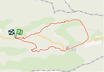
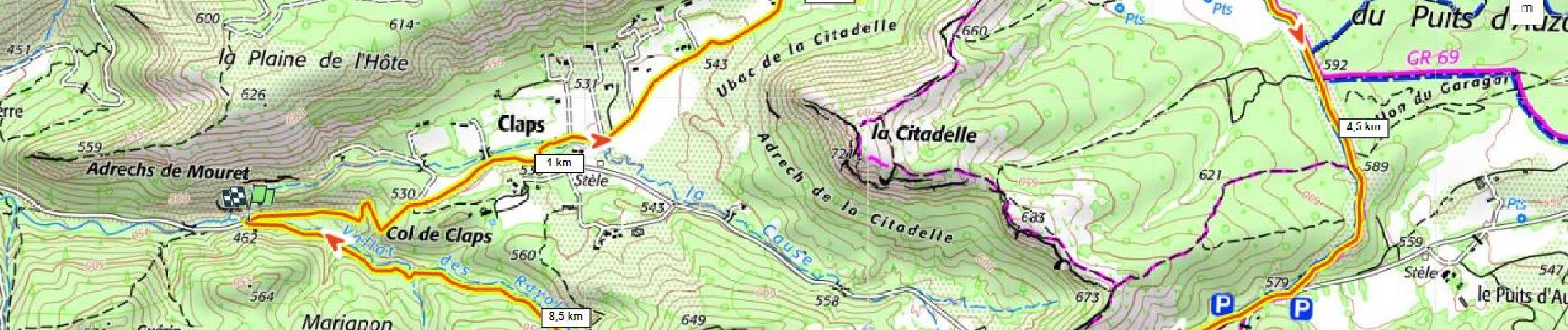
15,8 km | 28 km-effort
4h 36min
Oui
Randonnée Marche Vauvenargues - Le Signal, Montagne Sainte-Victoire - Photo
Marche
tracegps

Marche

Moyen
(2)
Vauvenargues, Provence-Alpes-Côte d'Azur, Bouches-du-Rhône, France
15 km | 25 km-effort
6h 19min
Oui
Randonnée Marche Saint-Antonin-sur-Bayon - 2023-02-10 Sainte Victoire Bau des Vespres - Photo
Marche
GUIDE
Kargil

Marche

Difficile
Saint-Antonin-sur-Bayon, Provence-Alpes-Côte d'Azur, Bouches-du-Rhône, France
10 km | 18,8 km-effort
3h 30min
Oui
Randonnée Marche Puyloubier - 2023-02-03 Sainte Victoire - Le Pic des Mouches - Photo
Marche
GUIDE
Kargil

Marche

Difficile
Puyloubier, Provence-Alpes-Côte d'Azur, Bouches-du-Rhône, France
10 km | 19 km-effort
3h 10min
Oui
Randonnée A pied Vauvenargues - Sentier des Venturiers - Photo
A pied
GUIDE+

A pied

Facile
Vauvenargues, Provence-Alpes-Côte d'Azur, Bouches-du-Rhône, France
5 km | 10,5 km-effort
2h 23min
Non
Randonnée Marche Saint-Antonin-sur-Bayon - le Garagai, signal  - Photo
Marche
GUIDE
nadd73

Marche

Difficile
Saint-Antonin-sur-Bayon, Provence-Alpes-Côte d'Azur, Bouches-du-Rhône, France
6,8 km | 14,1 km-effort
3h 38min
Oui
Randonnée Marche Puyloubier - Pic dès mouches puyloubier - Photo
Marche
GUIDE
nadd73

Marche

Facile
Puyloubier, Provence-Alpes-Côte d'Azur, Bouches-du-Rhône, France
6,8 km | 15,2 km-effort
4h 52min
Oui
Randonnée Marche Saint-Antonin-sur-Bayon - pas du clapier et tracé vert - Photo
Marche
GUIDE
amiral13

Marche

Difficile
Saint-Antonin-sur-Bayon, Provence-Alpes-Côte d'Azur, Bouches-du-Rhône, France
10,5 km | 21 km-effort
5h 24min
Oui
Randonnée Marche Jouques - le Concors - Photo
Marche
GUIDE
amiral13

Marche

Facile
Jouques, Provence-Alpes-Côte d'Azur, Bouches-du-Rhône, France
8,5 km | 14,4 km-effort
3h 31min
Oui


Fermer
Mes abonnements