![](/images/other/stat-length.png)
![Randonnée Marche Dison - DISON _ Marche Fédérale _ LG _ 27/05/2023 - Photo](https://media.geolcdn.com/t/1900/400/852757bb-5d7b-402a-b02f-decc1f3d5217.jpg&format=pjpeg&maxdim=2)
DISON _ Marche Fédérale _ LG _ 27/05/2023
jeangulu
Utilisateur
![Longueur](/images/other/stat-length.png)
Longueur
20 km
![Altitude max](https://static1.geolcdn.com/siteimages/upload/files/1508320355ic_sort_altitude_max_24dp.png)
Altitude max
295 m
![Dénivelé positif](https://static1.geolcdn.com/siteimages/upload/files/1508320355ic_sort_den_pos_24dp.png)
Dénivelé positif
493 m
![Km-Effort](/images/other/stat-length.png)
Km-Effort
27 km
![Altitude min](https://static1.geolcdn.com/siteimages/upload/files/1508320355ic_sort_altitude_min_24dp.png)
Altitude min
178 m
![Dénivelé négatif](https://static1.geolcdn.com/siteimages/upload/files/1508320355ic_sort_den_neg_24dp.png)
Dénivelé négatif
492 m
![Boucle](https://static1.geolcdn.com/siteimages/upload/files/16400158638029165_repeat_loop_refresh_sync_direction_icon.png)
Boucle
Oui
Date de création :
2023-05-27 07:51:36.375
Dernière modification :
2023-05-27 12:58:43.511
![Marche](https://static1.geolcdn.com/sitytour/trail-icons/101.png)
5h06
Difficulté : Moyen
![Scannez ce code QR pour ouvrir la randonnée dans l'application SityTrail](https://capi.geolives.com/qq0zvz2zws4bq2lad0pu/sitytour/trails/3676206/qr.png?size=200)
Application GPS de randonnée GRATUITE
À propos
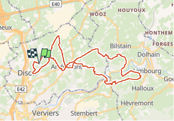
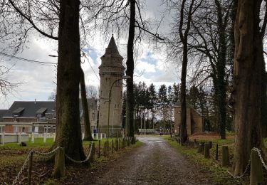
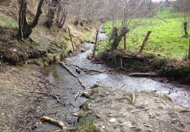
Randonnée Marche de 20 km à découvrir à Wallonie, Liège, Dison. Cette randonnée est proposée par jeangulu.
Description
Point de départ : Cercle Royal Saint Jean-Baptiste _ Rue de Mont 155 _ 4820 - DISON.
Organisateur : LG 185 _ LES PIEDS MONTOIS.
Carte IGN : 48/8.
Marche du jour.
Localisation
Pays :
Belgique
Région :
Wallonie
Département/Province :
Liège
Commune :
Dison
Localité :
Unknown
Départ:(Dec)
Départ:(UTM)
702575 ; 5610962 (31U) N.
Commentaires
Randonnées à proximité
![Randonnée Marche Verviers - Grand vivier - Cossart - Photo](https://media.geolcdn.com/t/375/260/ext.jpg?maxdim=2&url=https%3A%2F%2Fstatic1.geolcdn.com%2Fsiteimages%2Fupload%2Ffiles%2F1553511878bg_sport_marche.png)
![Marche Marche](https://static1.geolcdn.com/sitytour/trail-icons/101.png)
Grand vivier - Cossart
Marche
Facile
(5)
Verviers,
Wallonie,
Liège,
Belgique
![](/images/other/stat-length.png)
4,7 km | 6,4 km-effort
1h 26min
![](https://static1.geolcdn.com/siteimages/upload/files/16400158638029165_repeat_loop_refresh_sync_direction_icon.png)
Oui
![Randonnée Marche Herve - Thimister et son Marché de Noël 🎅🎄 alsacien 🥨 - Photo](https://media.geolcdn.com/t/375/260/3e67f0de-4933-4699-a966-0b37dcd8155f.jpg&format=jpg&maxdim=2)
![Marche Marche](https://static1.geolcdn.com/sitytour/trail-icons/101.png)
Thimister et son Marché de Noël 🎅🎄 alsacien 🥨
Marche
Facile
(1)
Herve,
Wallonie,
Liège,
Belgique
![](/images/other/stat-length.png)
12,7 km | 15,4 km-effort
2h 46min
![](https://static1.geolcdn.com/siteimages/upload/files/16400158638029165_repeat_loop_refresh_sync_direction_icon.png)
Oui
![Marche Marche](https://static1.geolcdn.com/sitytour/trail-icons/101.png)
20220327 - Fort de Battice - 6.7 Km
Marche
Moyen
(2)
Herve,
Wallonie,
Liège,
Belgique
![](/images/other/stat-length.png)
6,3 km | 8 km-effort
2h 1min
![](https://static1.geolcdn.com/siteimages/upload/files/16400158638029165_repeat_loop_refresh_sync_direction_icon.png)
Oui
![Marche Marche](https://static1.geolcdn.com/sitytour/trail-icons/101.png)
20210214 - Bruyères 5 Km
Marche
Facile
(1)
Herve,
Wallonie,
Liège,
Belgique
![](/images/other/stat-length.png)
5,3 km | 6,6 km-effort
1h 41min
![](https://static1.geolcdn.com/siteimages/upload/files/16400158638029165_repeat_loop_refresh_sync_direction_icon.png)
Oui
![Randonnée Marche Herve - Grand-Rechain 🎅🎄 - Photo](https://media.geolcdn.com/t/375/260/4ac1b489-a981-486f-9575-913bd20e929a.jpg&format=jpg&maxdim=2)
![Marche Marche](https://static1.geolcdn.com/sitytour/trail-icons/101.png)
Grand-Rechain 🎅🎄
Marche
Facile
(1)
Herve,
Wallonie,
Liège,
Belgique
![](/images/other/stat-length.png)
7,4 km | 8,8 km-effort
2h 0min
![](https://static1.geolcdn.com/siteimages/upload/files/16400158638029165_repeat_loop_refresh_sync_direction_icon.png)
Oui
![Randonnée Marche Verviers - Stembert . les Roudoudous . Stembert - Photo](https://media.geolcdn.com/t/375/260/83013b57-22fc-4f55-b86f-1cd16e0258d4.jpg&format=jpg&maxdim=2)
![Marche Marche](https://static1.geolcdn.com/sitytour/trail-icons/101.png)
Stembert . les Roudoudous . Stembert
Marche
Facile
(2)
Verviers,
Wallonie,
Liège,
Belgique
![](/images/other/stat-length.png)
10,5 km | 13,5 km-effort
2h 48min
![](https://static1.geolcdn.com/siteimages/upload/files/16400158638029165_repeat_loop_refresh_sync_direction_icon.png)
Oui
![Randonnée Marche Herve - Grand-Rechain - Photo](https://media.geolcdn.com/t/375/260/cdd454a5-b566-423c-bb32-93bef350c0ca.jpg&format=jpg&maxdim=2)
![Marche Marche](https://static1.geolcdn.com/sitytour/trail-icons/101.png)
Grand-Rechain
Marche
Facile
(2)
Herve,
Wallonie,
Liège,
Belgique
![](/images/other/stat-length.png)
12,8 km | 15,3 km-effort
3h 29min
![](https://static1.geolcdn.com/siteimages/upload/files/16400158638029165_repeat_loop_refresh_sync_direction_icon.png)
Oui
![Randonnée V.T.T. Verviers - VAE Stembert/Gileppe/Eupen/Mariehomont 40Km - Photo](https://media.geolcdn.com/t/375/260/065d690c-d4f8-46e5-b8c7-553390be2eee.jpg&format=jpg&maxdim=2)
![V.T.T. V.T.T.](https://static1.geolcdn.com/sitytour/trail-icons/202.png)
VAE Stembert/Gileppe/Eupen/Mariehomont 40Km
V.T.T.
Très difficile
(1)
Verviers,
Wallonie,
Liège,
Belgique
![](/images/other/stat-length.png)
41 km | 55 km-effort
3h 50min
![](https://static1.geolcdn.com/siteimages/upload/files/16400158638029165_repeat_loop_refresh_sync_direction_icon.png)
Oui
![Randonnée Marche Pepinster - Wegnez Soiron - Photo](https://media.geolcdn.com/t/375/260/ext.jpg?maxdim=2&url=https%3A%2F%2Fservices.sitytrail.com%2FGeolivesWS%2FDownloadMedia.ashx%3FTrailID%3D548760%26Media%3D20160403160555.jpg)
![Marche Marche](https://static1.geolcdn.com/sitytour/trail-icons/101.png)
Wegnez Soiron
Marche
Moyen
(4)
Pepinster,
Wallonie,
Liège,
Belgique
![](/images/other/stat-length.png)
7,9 km | 9,8 km-effort
2h 6min
![](https://static1.geolcdn.com/siteimages/upload/files/16400158638029165_repeat_loop_refresh_sync_direction_icon.png)
Oui