![](/images/other/stat-length.png)
![Randonnée Marche Crevant - Circuit pédestre des croix et des châtaigniers - Photo](https://media.geolcdn.com/t/1900/400/ext.pjpeg?maxdim=2&url=https%3A%2F%2Fstatic1.geolcdn.com%2Fsiteimages%2Fupload%2Ffiles%2F1553511878bg_sport_marche.png)
Circuit pédestre des croix et des châtaigniers
fanthou
Utilisateur
![Longueur](/images/other/stat-length.png)
Longueur
6 km
![Altitude max](https://static1.geolcdn.com/siteimages/upload/files/1508320355ic_sort_altitude_max_24dp.png)
Altitude max
374 m
![Dénivelé positif](https://static1.geolcdn.com/siteimages/upload/files/1508320355ic_sort_den_pos_24dp.png)
Dénivelé positif
112 m
![Km-Effort](/images/other/stat-length.png)
Km-Effort
7,5 km
![Altitude min](https://static1.geolcdn.com/siteimages/upload/files/1508320355ic_sort_altitude_min_24dp.png)
Altitude min
323 m
![Dénivelé négatif](https://static1.geolcdn.com/siteimages/upload/files/1508320355ic_sort_den_neg_24dp.png)
Dénivelé négatif
111 m
![Boucle](https://static1.geolcdn.com/siteimages/upload/files/16400158638029165_repeat_loop_refresh_sync_direction_icon.png)
Boucle
Oui
Date de création :
2023-05-27 09:39:09.297
Dernière modification :
2023-05-27 09:39:56.347
![Marche](https://static1.geolcdn.com/sitytour/trail-icons/101.png)
1h41
Difficulté : Facile
![Scannez ce code QR pour ouvrir la randonnée dans l'application SityTrail](https://capi.geolives.com/qq0zvz2zws4bq2lad0pu/sitytour/trails/3675967/qr.png?size=200)
Application GPS de randonnée GRATUITE
À propos
Randonnée Marche de 6 km à découvrir à Centre-Val de Loire, Indre, Crevant. Cette randonnée est proposée par fanthou.
Description
Un parcours familial au départ de Crevant dans un bocage vallonné, parcouru par la Couarde, où le granit brut ou transformé par l’homme règne en maître. Téléchargement du circuit dans la rubrique "accès site web".
Localisation
Pays :
France
Région :
Centre-Val de Loire
Département/Province :
Indre
Commune :
Crevant
Localité :
Unknown
Départ:(Dec)
Départ:(UTM)
419141 ; 5148752 (31T) N.
Commentaires
Randonnées à proximité
![Randonnée V.T.C. Pouligny-Notre-Dame - autour des Dryades - Photo](https://media.geolcdn.com/t/375/260/2a88c383-2d3f-4c0b-a2e0-0f424360315b.jpg&format=jpg&maxdim=2)
![V.T.C. V.T.C.](https://static1.geolcdn.com/sitytour/trail-icons/203.png)
autour des Dryades
V.T.C.
Facile
Pouligny-Notre-Dame,
Centre-Val de Loire,
Indre,
France
![](/images/other/stat-length.png)
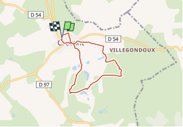
8 km | 9,8 km-effort
1h 30min
![](https://static1.geolcdn.com/siteimages/upload/files/16400158638029165_repeat_loop_refresh_sync_direction_icon.png)
Oui
![Randonnée Marche Pouligny-Notre-Dame - Circuit pédestre n° 81](https://media.geolcdn.com/t/375/260/ext.jpg?maxdim=2&url=https%3A%2F%2Fstatic1.geolcdn.com%2Fsiteimages%2Fupload%2Ffiles%2F1553511878bg_sport_marche.png)
![Marche Marche](https://static1.geolcdn.com/sitytour/trail-icons/101.png)
Circuit pédestre n° 81 "sentier Ô fil de l'eau"
Marche
Moyen
Pouligny-Notre-Dame,
Centre-Val de Loire,
Indre,
France
![](/images/other/stat-length.png)
10,5 km | 13 km-effort
2h 56min
![](https://static1.geolcdn.com/siteimages/upload/files/16400158638029165_repeat_loop_refresh_sync_direction_icon.png)
Oui
![Randonnée V.T.C. Pouligny-Notre-Dame - Dryades la châtre - Photo](https://media.geolcdn.com/t/375/260/ext.jpg?maxdim=2&url=https%3A%2F%2Fstatic1.geolcdn.com%2Fsiteimages%2Fupload%2Ffiles%2F1524743154velo.jpg)
![V.T.C. V.T.C.](https://static1.geolcdn.com/sitytour/trail-icons/203.png)
Dryades la châtre
V.T.C.
Très facile
Pouligny-Notre-Dame,
Centre-Val de Loire,
Indre,
France
![](/images/other/stat-length.png)
12,2 km | 13,6 km-effort
51min
![](https://static1.geolcdn.com/siteimages/upload/files/16400158638029165_repeat_loop_refresh_sync_direction_icon.png)
Non
![Randonnée Vélo électrique Crevant - Valignon-Villebasse-Fragne-Valignon - Photo](https://media.geolcdn.com/t/375/260/ext.jpg?maxdim=2&url=https%3A%2F%2Fstatic1.geolcdn.com%2Fsiteimages%2Fupload%2Ffiles%2F1524743154velo.jpg)
![Vélo électrique Vélo électrique](https://static1.geolcdn.com/sitytour/trail-icons/205.png)
Valignon-Villebasse-Fragne-Valignon
Vélo électrique
Moyen
Crevant,
Centre-Val de Loire,
Indre,
France
![](/images/other/stat-length.png)
23 km | 28 km-effort
Inconnu
![](https://static1.geolcdn.com/siteimages/upload/files/16400158638029165_repeat_loop_refresh_sync_direction_icon.png)
Oui
![Randonnée Moteur Crozon-sur-Vauvre - 2011 12 04 12h38m20 - Photo](https://media.geolcdn.com/t/375/260/ext.jpg?maxdim=2&url=https%3A%2F%2Fstatic1.geolcdn.com%2Fsiteimages%2Fupload%2Ffiles%2F15247431544x4.jpg)
![Moteur Moteur](https://static1.geolcdn.com/sitytour/trail-icons/400.png)
2011 12 04 12h38m20
Moteur
Difficile
(1)
Crozon-sur-Vauvre,
Centre-Val de Loire,
Indre,
France
![](/images/other/stat-length.png)
90 km | 111 km-effort
Inconnu
![](https://static1.geolcdn.com/siteimages/upload/files/16400158638029165_repeat_loop_refresh_sync_direction_icon.png)
Oui
![Randonnée Moteur Crozon-sur-Vauvre - 2011-12-04 12h38m20 - Photo](https://media.geolcdn.com/t/375/260/ext.jpg?maxdim=2&url=https%3A%2F%2Fstatic1.geolcdn.com%2Fsiteimages%2Fupload%2Ffiles%2F15247431544x4.jpg)
![Moteur Moteur](https://static1.geolcdn.com/sitytour/trail-icons/400.png)
2011-12-04 12h38m20
Moteur
Difficile
Crozon-sur-Vauvre,
Centre-Val de Loire,
Indre,
France
![](/images/other/stat-length.png)
90 km | 111 km-effort
3h 48min
![](https://static1.geolcdn.com/siteimages/upload/files/16400158638029165_repeat_loop_refresh_sync_direction_icon.png)
Oui