![](/images/other/stat-length.png)
![Randonnée Marche Bizou - Bizou - Les sables du Perche 9,2 km - Photo](https://media.geolcdn.com/t/1900/400/6b586e88-fad3-40df-be07-9b2a61186b9b.jpeg&format=pjpeg&maxdim=2)
Bizou - Les sables du Perche 9,2 km
ODDAD78
Utilisateur
![Longueur](/images/other/stat-length.png)
![Altitude max](https://static1.geolcdn.com/siteimages/upload/files/1508320355ic_sort_altitude_max_24dp.png)
![Dénivelé positif](https://static1.geolcdn.com/siteimages/upload/files/1508320355ic_sort_den_pos_24dp.png)
![Km-Effort](/images/other/stat-length.png)
![Altitude min](https://static1.geolcdn.com/siteimages/upload/files/1508320355ic_sort_altitude_min_24dp.png)
![Dénivelé négatif](https://static1.geolcdn.com/siteimages/upload/files/1508320355ic_sort_den_neg_24dp.png)
![Boucle](https://static1.geolcdn.com/siteimages/upload/files/16400158638029165_repeat_loop_refresh_sync_direction_icon.png)
![Marche](https://static1.geolcdn.com/sitytour/trail-icons/101.png)
2h29
Difficulté : Moyen
![V.T.T.](https://static1.geolcdn.com/sitytour/trail-icons/202.png)
45m
Difficulté : Facile
![Scannez ce code QR pour ouvrir la randonnée dans l'application SityTrail](https://capi.geolives.com/qq0zvz2zws4bq2lad0pu/sitytour/trails/3673978/qr.png?size=200)
Application GPS de randonnée GRATUITE
À propos
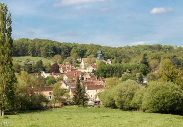
Randonnée Marche de 9,2 km à découvrir à Normandie, Orne, Bizou. Cette randonnée est proposée par ODDAD78.
Description
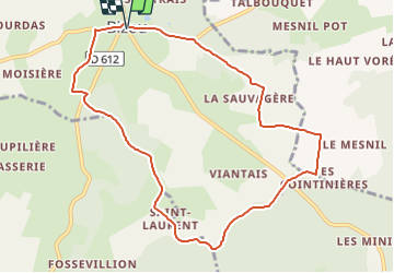
Départ / Arrivée : Bizou
Communes traversées : Bizou, Le Mage, Rémalard, Boissy-Maugis
Depuis le parking de la mairie (face à elle), partir sur gauche.
Prendre la 1ère à droite (rue du bocage) et monter tranquillement en bord de route.
Laisser "La Bruyère du marronnier" sur gauche et prendre à droite, dans la forêt. Monter tranquillement. Passer la Sauvagère (sur gauche) et poursuivre vers La Pichardière. Tourner à droite : ça monte encore tranquillement.
Bien rester sur le chemin, à gauche (ne pas suivre le chemin enherbé qui part sur droite en tournant). Arrivé face à un pré, tourner à droite et poursuivre par un chemin d'herbe sur du plat.
Prendre à droite. PRUDENCE ensuite, vous aller traverser une route. Poursuivre par le chemin en face. Restez bien sur le chemin communal (la forêt sur gauche est privée : des panneaux le rappellent régulièrement).
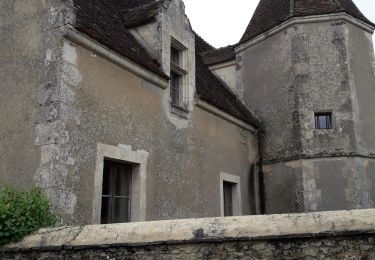
Sur droite, contourner une belle maison (Les Gouptières), en tournant sur droite. Poursuivre tout droit (jeunes arbres plantés en haie sur droite et beau chêne sur gauche). Passer devant quelques maisons sur droite (hameau de Saint-Laurent) et poursuivre sur la petite route jusqu'à la Guéroudière.
Tourner à gauche et passer un bois situé en hauteur (beaux points de vue dégagés sur les collines environnantes). Présence de nombreux bouleaux.
PRUDENCE en traversant la D 612. Sur la D 612, prendre la 1ère à gauche et monter par un adorable chemin. Arrivé à un croisement de chemins : retournez vous pour admirer la vue !
Puis prendre à droite : superbe chemin longé d'arbres farfelus et offrant de beaux points de vue. Arrivé sur la route, prendre à droite pour retourner vers le centre-bourg de Bizou, puis encore à droite pour rejoindre le parking.
(pas à pas Rando-Perche https://rando-perche.fr/a-pied/les-sables-du-perche/)
Localisation
Commentaires
Randonnées à proximité
![Randonnée Marche Longny les Villages - Monceaux au Perche (Boucle) - Photo](https://media.geolcdn.com/t/375/260/ext.jpg?maxdim=2&url=https%3A%2F%2Fstatic1.geolcdn.com%2Fsiteimages%2Fupload%2Ffiles%2F1553511878bg_sport_marche.png)
![Marche Marche](https://static1.geolcdn.com/sitytour/trail-icons/101.png)
Marche
![](/images/other/stat-length.png)
![](https://static1.geolcdn.com/siteimages/upload/files/16400158638029165_repeat_loop_refresh_sync_direction_icon.png)
![Randonnée Marche Longny les Villages - Longny-au-Perche La Brisardière 3,5 km - Photo](https://media.geolcdn.com/t/375/260/19108d03-3d8a-43b4-b05b-172408edde68.jpeg&format=jpg&maxdim=2)
![Marche Marche](https://static1.geolcdn.com/sitytour/trail-icons/101.png)
Marche
![](/images/other/stat-length.png)
![](https://static1.geolcdn.com/siteimages/upload/files/16400158638029165_repeat_loop_refresh_sync_direction_icon.png)
![Randonnée A pied Longny les Villages - Attelage - Forêt et Panoramas - forêt de Réno-Valdieu - Photo](https://media.geolcdn.com/t/375/260/db99a0ed-9413-4500-8368-446623bccd86.jpeg&format=jpg&maxdim=2)
![A pied A pied](https://static1.geolcdn.com/sitytour/trail-icons/100.png)
A pied
![](/images/other/stat-length.png)
![](https://static1.geolcdn.com/siteimages/upload/files/16400158638029165_repeat_loop_refresh_sync_direction_icon.png)
![Randonnée Marche Cour-Maugis sur Huisne - Maison Maugis 22.37 - Photo](https://media.geolcdn.com/t/375/260/ext.jpg?maxdim=2&url=https%3A%2F%2Fstatic1.geolcdn.com%2Fsiteimages%2Fupload%2Ffiles%2F1553511878bg_sport_marche.png)
![Marche Marche](https://static1.geolcdn.com/sitytour/trail-icons/101.png)
Marche
![](/images/other/stat-length.png)
![](https://static1.geolcdn.com/siteimages/upload/files/16400158638029165_repeat_loop_refresh_sync_direction_icon.png)
![Randonnée Marche Le Mage - Le Mage - Longny-au-Perche (Longny les Villages) 11 km - Photo](https://media.geolcdn.com/t/375/260/7da85c06-6bc5-432c-afb8-5444ae0d01ad.jpg&format=jpg&maxdim=2)
![Marche Marche](https://static1.geolcdn.com/sitytour/trail-icons/101.png)
Marche
![](/images/other/stat-length.png)
![](https://static1.geolcdn.com/siteimages/upload/files/16400158638029165_repeat_loop_refresh_sync_direction_icon.png)
![Randonnée Marche Le Mage - Le Mage - Moutiers-au-Perche 9,2 km - Photo](https://media.geolcdn.com/t/375/260/2d6a74b1-d9ee-4f0d-9acb-9c00ceb2d8ab.jpg&format=jpg&maxdim=2)
![Marche Marche](https://static1.geolcdn.com/sitytour/trail-icons/101.png)
Marche
![](/images/other/stat-length.png)
![](https://static1.geolcdn.com/siteimages/upload/files/16400158638029165_repeat_loop_refresh_sync_direction_icon.png)
![Randonnée Marche Longny les Villages - Monceaux et le Manoir - Photo](https://media.geolcdn.com/t/375/260/2c895f3a-5924-449a-a873-4ad274746411.jpg&format=jpg&maxdim=2)
![Marche Marche](https://static1.geolcdn.com/sitytour/trail-icons/101.png)
Marche
![](/images/other/stat-length.png)
![](https://static1.geolcdn.com/siteimages/upload/files/16400158638029165_repeat_loop_refresh_sync_direction_icon.png)
![Randonnée Marche Longny les Villages - Minceaux 2 - Photo](https://media.geolcdn.com/t/375/260/7d79a233-230a-4321-b3f2-9bfbb749ff7a.jpg&format=jpg&maxdim=2)
![Marche Marche](https://static1.geolcdn.com/sitytour/trail-icons/101.png)
Marche
![](/images/other/stat-length.png)
![](https://static1.geolcdn.com/siteimages/upload/files/16400158638029165_repeat_loop_refresh_sync_direction_icon.png)
![Randonnée Marche Longny les Villages - Monceaux-au-Perche - Nocé-Courboyer 15 km - Photo](https://media.geolcdn.com/t/375/260/abea7f8c-ef8c-42f2-9a81-cb0da5f3935f.jpg&format=jpg&maxdim=2)
![Marche Marche](https://static1.geolcdn.com/sitytour/trail-icons/101.png)
Marche
![](/images/other/stat-length.png)
![](https://static1.geolcdn.com/siteimages/upload/files/16400158638029165_repeat_loop_refresh_sync_direction_icon.png)