![](/images/other/stat-length.png)
![Randonnée Marche Houffalize - Sentier Canal de Bernistap - Photo](https://media.geolcdn.com/t/1900/400/ext.pjpeg?maxdim=2&url=https%3A%2F%2Fstatic1.geolcdn.com%2Fsiteimages%2Fupload%2Ffiles%2F1553511878bg_sport_marche.png)
Sentier Canal de Bernistap
danyhermans1607@gmail.com
Utilisateur
![Longueur](/images/other/stat-length.png)
Longueur
15 km
![Altitude max](https://static1.geolcdn.com/siteimages/upload/files/1508320355ic_sort_altitude_max_24dp.png)
Altitude max
516 m
![Dénivelé positif](https://static1.geolcdn.com/siteimages/upload/files/1508320355ic_sort_den_pos_24dp.png)
Dénivelé positif
267 m
![Km-Effort](/images/other/stat-length.png)
Km-Effort
18,6 km
![Altitude min](https://static1.geolcdn.com/siteimages/upload/files/1508320355ic_sort_altitude_min_24dp.png)
Altitude min
420 m
![Dénivelé négatif](https://static1.geolcdn.com/siteimages/upload/files/1508320355ic_sort_den_neg_24dp.png)
Dénivelé négatif
267 m
![Boucle](https://static1.geolcdn.com/siteimages/upload/files/16400158638029165_repeat_loop_refresh_sync_direction_icon.png)
Boucle
Oui
Date de création :
2023-05-25 10:32:10.004
Dernière modification :
2023-05-25 10:35:09.927
![Marche](https://static1.geolcdn.com/sitytour/trail-icons/101.png)
4h13
Difficulté : Difficile
![Scannez ce code QR pour ouvrir la randonnée dans l'application SityTrail](https://capi.geolives.com/qq0zvz2zws4bq2lad0pu/sitytour/trails/3673315/qr.png?size=200)
Application GPS de randonnée GRATUITE
À propos
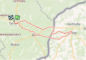
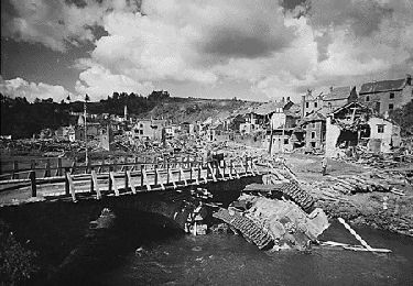
Randonnée Marche de 15 km à découvrir à Wallonie, Luxembourg, Houffalize. Cette randonnée est proposée par danyhermans1607@gmail.com .
Description
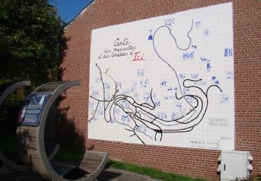
Boucle autour du site du projet de canal Meuse/Moselle de Guillaume d'Orange en 1929 avec quelques vestige du chantier et des panneaux explicatifs le long du parcours
Localisation
Pays :
Belgique
Région :
Wallonie
Département/Province :
Luxembourg
Commune :
Houffalize
Localité :
Unknown
Départ:(Dec)
Départ:(UTM)
702911 ; 5554542 (31U) N.
Commentaires
Randonnées à proximité
![Randonnée Marche Houffalize - RB-Lu-06_Vissoûle - Photo](https://media.geolcdn.com/t/375/260/ext.jpg?maxdim=2&url=https%3A%2F%2Fservices.sitytrail.com%2FGeolivesWS%2FDownloadMedia.ashx%3FTrailID%3D179619%26Media%3D8b2c6c16-f84f-40f5-b4fd-5755f63e797b.jpg)
![Marche Marche](https://static1.geolcdn.com/sitytour/trail-icons/101.png)
RB-Lu-06_Vissoûle
Marche
Moyen
(5)
Houffalize,
Wallonie,
Luxembourg,
Belgique
![](/images/other/stat-length.png)
22 km | 29 km-effort
6h 12min
![](https://static1.geolcdn.com/siteimages/upload/files/16400158638029165_repeat_loop_refresh_sync_direction_icon.png)
Oui
![Randonnée Marche Houffalize - Houffalize 24 Km - Photo](https://media.geolcdn.com/t/375/260/f2a4fe24-3182-45a1-8c4e-78921a8d2df8.jpg&format=jpg&maxdim=2)
![Marche Marche](https://static1.geolcdn.com/sitytour/trail-icons/101.png)
Houffalize 24 Km
Marche
Très facile
(1)
Houffalize,
Wallonie,
Luxembourg,
Belgique
![](/images/other/stat-length.png)
25 km | 33 km-effort
7h 55min
![](https://static1.geolcdn.com/siteimages/upload/files/16400158638029165_repeat_loop_refresh_sync_direction_icon.png)
Oui
![Randonnée Marche Houffalize - Pont de Suhet - Photo](https://media.geolcdn.com/t/375/260/ext.jpg?maxdim=2&url=https%3A%2F%2Fservices.sitytrail.com%2FGeolivesWS%2FDownloadMedia.ashx%3FTrailID%3D485759%26Media%3Dc0a9257a-f8ac-4145-a29f-af09ef232c22.jpg)
![Marche Marche](https://static1.geolcdn.com/sitytour/trail-icons/101.png)
Pont de Suhet
Marche
Difficile
(2)
Houffalize,
Wallonie,
Luxembourg,
Belgique
![](/images/other/stat-length.png)
14,6 km | 20 km-effort
3h 20min
![](https://static1.geolcdn.com/siteimages/upload/files/16400158638029165_repeat_loop_refresh_sync_direction_icon.png)
Oui
![Randonnée Marche Houffalize - Chapelle Saint Roch - Photo](https://media.geolcdn.com/t/375/260/ext.jpg?maxdim=2&url=https%3A%2F%2Fservices.sitytrail.com%2FGeolivesWS%2FDownloadMedia.ashx%3FTrailID%3D485651%26Media%3Deb728c68-2a3c-4799-8033-bf1dbca1b439.jpg)
![Marche Marche](https://static1.geolcdn.com/sitytour/trail-icons/101.png)
Chapelle Saint Roch
Marche
Facile
(2)
Houffalize,
Wallonie,
Luxembourg,
Belgique
![](/images/other/stat-length.png)
7,1 km | 9,4 km-effort
2h 3min
![](https://static1.geolcdn.com/siteimages/upload/files/16400158638029165_repeat_loop_refresh_sync_direction_icon.png)
Non
![Randonnée Marche Houffalize - Alhoumont - Photo](https://media.geolcdn.com/t/375/260/ext.jpg?maxdim=2&url=https%3A%2F%2Fservices.sitytrail.com%2FGeolivesWS%2FDownloadMedia.ashx%3FTrailID%3D485603%26Media%3Dab9e328f-2fba-4db4-9e4f-b4c6fc69c80e.jpg)
![Marche Marche](https://static1.geolcdn.com/sitytour/trail-icons/101.png)
Alhoumont
Marche
Facile
(3)
Houffalize,
Wallonie,
Luxembourg,
Belgique
![](/images/other/stat-length.png)
5,3 km | 7,2 km-effort
2h 0min
![](https://static1.geolcdn.com/siteimages/upload/files/16400158638029165_repeat_loop_refresh_sync_direction_icon.png)
Non
![Randonnée Marche Houffalize - Tour de ville d'Houffalize - Photo](https://media.geolcdn.com/t/375/260/ext.jpg?maxdim=2&url=https%3A%2F%2Fservices.sitytrail.com%2FGeolivesWS%2FDownloadMedia.ashx%3FTrailID%3D481711%26Media%3Dd8f3bf4c-0099-44fd-93ae-681a17a948e5.jpg)
![Marche Marche](https://static1.geolcdn.com/sitytour/trail-icons/101.png)
Tour de ville d'Houffalize
Marche
Très facile
(2)
Houffalize,
Wallonie,
Luxembourg,
Belgique
![](/images/other/stat-length.png)
3,5 km | 4 km-effort
1h 0min
![](https://static1.geolcdn.com/siteimages/upload/files/16400158638029165_repeat_loop_refresh_sync_direction_icon.png)
Oui
![Randonnée Marche Houffalize - La Roche Plate - Photo](https://media.geolcdn.com/t/375/260/ext.jpg?maxdim=2&url=https%3A%2F%2Fservices.sitytrail.com%2FGeolivesWS%2FDownloadMedia.ashx%3FTrailID%3D481768%26Media%3D8e795a23-645a-4206-bdf9-d3914a4b6e5c.jpg)
![Marche Marche](https://static1.geolcdn.com/sitytour/trail-icons/101.png)
La Roche Plate
Marche
Facile
(5)
Houffalize,
Wallonie,
Luxembourg,
Belgique
![](/images/other/stat-length.png)
3,5 km | 4,8 km-effort
1h 30min
![](https://static1.geolcdn.com/siteimages/upload/files/16400158638029165_repeat_loop_refresh_sync_direction_icon.png)
Oui
![Randonnée Marche Houffalize - Balade à Houffalize - Photo](https://media.geolcdn.com/t/375/260/297ac34f-7885-4569-9df7-ddc20077a008.jpg&format=jpg&maxdim=2)
![Marche Marche](https://static1.geolcdn.com/sitytour/trail-icons/101.png)
Balade à Houffalize
Marche
Moyen
(1)
Houffalize,
Wallonie,
Luxembourg,
Belgique
![](/images/other/stat-length.png)
8,5 km | 11,4 km-effort
2h 35min
![](https://static1.geolcdn.com/siteimages/upload/files/16400158638029165_repeat_loop_refresh_sync_direction_icon.png)
Oui
![Randonnée sport Houffalize - Le canal de Bernistap - Photo](https://media.geolcdn.com/t/375/260/ext.jpg?maxdim=2&url=https%3A%2F%2Fsecurestorage.geolives.com%2Fsitytour%2Ftrail-bg%2Fdefault.jpg)
Le canal de Bernistap
sport
Très facile
(1)
Houffalize,
Wallonie,
Luxembourg,
Belgique
![](/images/other/stat-length.png)
9,3 km | 11,5 km-effort
Inconnu
![](https://static1.geolcdn.com/siteimages/upload/files/16400158638029165_repeat_loop_refresh_sync_direction_icon.png)
Oui