Randonnée Voiture The Municipal District of Cahir — Cashel - j2-04 - Photo
 DUPORT16
DUPORT16

Utilisateur

© OpenStreetMap contributors
Longueur
Longueur
141 km
Altitude max
Altitude max
164 m
Dénivelé positif
Dénivelé positif
1043 m
Km-Effort
Km-Effort  
155 km
Altitude min
Altitude min
36 m
Dénivelé négatif
Dénivelé négatif
1112 m
Boucle
Boucle
Non
Date de création :
2023-05-24 14:36:30.327
Dernière modification :
2023-05-24 17:08:27.856

(0 Avis)

Voiture
Voiture
2h31
Difficulté : Très facile

Scannez ce code QR pour ouvrir la randonnée dans l'application SityTrail

Application GPS de randonnée GRATUITE

Logo SityTrail SityTrail

IGN / Instituts géographiques

Télécharger SityTrail sur l'App Store Télécharger SityTrail sur Google Play

Logo SityTrail SityTrail World

Le monde est à vous

Télécharger SityTrail sur l'App Store Télécharger SityTrail sur Google Play Télécharger SityTrail sur Huawei AppGallery

À propos

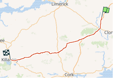
Randonnée Voiture de 141 km à découvrir à Inconnu, County Tipperary, The Municipal District of Cahir — Cashel. Cette randonnée est proposée par DUPORT16.

Profil altimétrique

Localisation

Pays :
Irlande
Région :
Inconnu
Département/Province :
County Tipperary
Commune :
The Municipal District of Cahir — Cashel
Localité :
Cashel Rural
Départ:(UTM)
575408 ; 5819480 (29U) N.

Randonnées à proximité

Randonnée Marche The Municipal District of Cahir — Cashel - Cahir Scaragh Wood Trail 2 - Photo
Marche
johnkeating

Marche

Très facile
The Municipal District of Cahir — Cashel, Inconnu, County Tipperary, Irlande
5,5 km | 7,4 km-effort
1h 15min
Oui
Randonnée Marche The Municipal District of Cahir — Cashel - Cahir Scaragh Wood Trail 1 - Photo
Marche
johnkeating

Marche

Très facile
The Municipal District of Cahir — Cashel, Inconnu, County Tipperary, Irlande
4,6 km | 5,9 km-effort
1h 0min
Oui
Randonnée Marche The Municipal District of Cahir — Cashel - Cahir Scaragh Wood Trail 3 - Photo
Marche
johnkeating

Marche

Très facile
The Municipal District of Cahir — Cashel, Inconnu, County Tipperary, Irlande
6,4 km | 9,4 km-effort
1h 35min
Oui
Randonnée Marche The Municipal District of Cahir — Cashel - Galtees - Lake Muskry Circuit - Photo
Marche
johnkeating

Marche

Très facile
The Municipal District of Cahir — Cashel, Inconnu, County Tipperary, Irlande
10,1 km | 18,2 km-effort
3h 10min
Non
Randonnée Course à pied The Municipal District of Cahir — Cashel - Bianconi Loop - Photo
Course à pied
mlmoroneybb

Course à pied

Facile
The Municipal District of Cahir — Cashel, Inconnu, County Tipperary, Irlande
3,8 km | 5,3 km-effort
2h 0min
Oui
Randonnée Course à pied The Municipal District of Cahir — Cashel - Ballinacourty Loop - Photo
Course à pied
mlmoroneybb

Course à pied

Moyen
The Municipal District of Cahir — Cashel, Inconnu, County Tipperary, Irlande
8,2 km | 10,9 km-effort
2h 0min
Oui
Randonnée Course à pied The Municipal District of Cahir — Cashel - The Millenium Stone Loop - Photo
Course à pied
mlmoroneybb

Course à pied

Moyen
The Municipal District of Cahir — Cashel, Inconnu, County Tipperary, Irlande
9,4 km | 12,4 km-effort
2h 0min
Oui
Randonnée Marche The Municipal District of Cahir — Cashel - Slievenamuck Walking Marathon Sunday March 24th 2013 - Photo
Marche
mlmoroneybb

Marche

Difficile
The Municipal District of Cahir — Cashel, Inconnu, County Tipperary, Irlande
42 km | 56 km-effort
11h 36min
Non
Randonnée Marche The Municipal District of Cahir — Cashel - Galtee Walking Club Marathon - Photo
Marche
mlmoroneybb

Marche

Difficile
The Municipal District of Cahir — Cashel, Inconnu, County Tipperary, Irlande
41 km | 54 km-effort
11h 22min
Oui


Fermer
Mes abonnements