![](/images/other/stat-length.png)
![Randonnée Randonnée équestre Saint-Malo-de-Guersac - TRAIL TOUR DE BRIERE - Photo](https://media.geolcdn.com/t/1900/400/ext.pjpeg?maxdim=2&url=https%3A%2F%2Fstatic1.geolcdn.com%2Fsiteimages%2Fupload%2Ffiles%2F1524743154cheval.jpg)
TRAIL TOUR DE BRIERE
Sevie44
Utilisateur
![Longueur](/images/other/stat-length.png)
Longueur
67 km
![Altitude max](https://static1.geolcdn.com/siteimages/upload/files/1508320355ic_sort_altitude_max_24dp.png)
Altitude max
16 m
![Dénivelé positif](https://static1.geolcdn.com/siteimages/upload/files/1508320355ic_sort_den_pos_24dp.png)
Dénivelé positif
269 m
![Km-Effort](/images/other/stat-length.png)
Km-Effort
71 km
![Altitude min](https://static1.geolcdn.com/siteimages/upload/files/1508320355ic_sort_altitude_min_24dp.png)
Altitude min
-5 m
![Dénivelé négatif](https://static1.geolcdn.com/siteimages/upload/files/1508320355ic_sort_den_neg_24dp.png)
Dénivelé négatif
268 m
![Boucle](https://static1.geolcdn.com/siteimages/upload/files/16400158638029165_repeat_loop_refresh_sync_direction_icon.png)
Boucle
Oui
Date de création :
2023-05-24 16:25:33.893
Dernière modification :
2023-05-24 16:34:49.181
![Randonnée équestre](https://static1.geolcdn.com/sitytour/trail-icons/301.png)
9h16
Difficulté : Très difficile
![Scannez ce code QR pour ouvrir la randonnée dans l'application SityTrail](https://capi.geolives.com/qq0zvz2zws4bq2lad0pu/sitytour/trails/3672279/qr.png?size=200)
Application GPS de randonnée GRATUITE
À propos
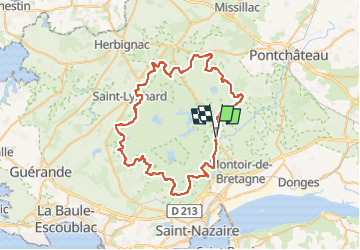
Randonnée Randonnée équestre de 67 km à découvrir à Pays de la Loire, Loire-Atlantique, Saint-Malo-de-Guersac. Cette randonnée est proposée par Sevie44.
Description
Responsable parcours : Jean-Paul EVAIN 06 78 84 41 21 - Jojo 06 47 88 18 38
Intendance : Stéphane 06 03 38 31 18 - Sonia 06 16 66 52 68
Localisation
Pays :
France
Région :
Pays de la Loire
Département/Province :
Loire-Atlantique
Commune :
Saint-Malo-de-Guersac
Localité :
Unknown
Départ:(Dec)
Départ:(UTM)
561334 ; 5245454 (30T) N.
Commentaires
Randonnées à proximité
![Randonnée A pied Saint-Malo-de-Guersac - Les Chaussées - Photo](https://media.geolcdn.com/t/375/260/ed9f4f37-5424-4cdf-97c9-60da3a524041.jpeg&format=jpg&maxdim=2)
![A pied A pied](https://static1.geolcdn.com/sitytour/trail-icons/100.png)
Les Chaussées
A pied
Facile
Saint-Malo-de-Guersac,
Pays de la Loire,
Loire-Atlantique,
France
![](/images/other/stat-length.png)
8,9 km | 9,3 km-effort
2h 6min
![](https://static1.geolcdn.com/siteimages/upload/files/16400158638029165_repeat_loop_refresh_sync_direction_icon.png)
Oui
![Randonnée A pied Saint-Malo-de-Guersac - Les Gagneries - Photo](https://media.geolcdn.com/t/375/260/ed9f4f37-5424-4cdf-97c9-60da3a524041.jpeg&format=jpg&maxdim=2)
![A pied A pied](https://static1.geolcdn.com/sitytour/trail-icons/100.png)
Les Gagneries
A pied
Facile
Saint-Malo-de-Guersac,
Pays de la Loire,
Loire-Atlantique,
France
![](/images/other/stat-length.png)
5,5 km | 5,7 km-effort
1h 18min
![](https://static1.geolcdn.com/siteimages/upload/files/16400158638029165_repeat_loop_refresh_sync_direction_icon.png)
Oui
![Randonnée Trail Saint-Joachim - Le Marais de Brière - Photo](https://media.geolcdn.com/t/375/260/99a527a7-ab93-418b-93bd-d1f371033538.jpg&format=jpg&maxdim=2)
![Trail Trail](https://static1.geolcdn.com/sitytour/trail-icons/104.png)
Le Marais de Brière
Trail
Moyen
Saint-Joachim,
Pays de la Loire,
Loire-Atlantique,
France
![](/images/other/stat-length.png)
15,3 km | 15,8 km-effort
1h 48min
![](https://static1.geolcdn.com/siteimages/upload/files/16400158638029165_repeat_loop_refresh_sync_direction_icon.png)
Oui
![Randonnée Marche Montoir-de-Bretagne - Briere - Photo](https://media.geolcdn.com/t/375/260/ext.jpg?maxdim=2&url=https%3A%2F%2Fstatic1.geolcdn.com%2Fsiteimages%2Fupload%2Ffiles%2F1553511878bg_sport_marche.png)
![Marche Marche](https://static1.geolcdn.com/sitytour/trail-icons/101.png)
Briere
Marche
Montoir-de-Bretagne,
Pays de la Loire,
Loire-Atlantique,
France
![](/images/other/stat-length.png)
5,9 km | 6,2 km-effort
1h 23min
![](https://static1.geolcdn.com/siteimages/upload/files/16400158638029165_repeat_loop_refresh_sync_direction_icon.png)
Non
![Randonnée Marche Saint-Malo-de-Guersac - Rando des Hérons 2019 - Photo](https://media.geolcdn.com/t/375/260/ext.jpg?maxdim=2&url=https%3A%2F%2Fstatic1.geolcdn.com%2Fsiteimages%2Fupload%2Ffiles%2F1553511878bg_sport_marche.png)
![Marche Marche](https://static1.geolcdn.com/sitytour/trail-icons/101.png)
Rando des Hérons 2019
Marche
Facile
Saint-Malo-de-Guersac,
Pays de la Loire,
Loire-Atlantique,
France
![](/images/other/stat-length.png)
15,4 km | 16,1 km-effort
3h 35min
![](https://static1.geolcdn.com/siteimages/upload/files/16400158638029165_repeat_loop_refresh_sync_direction_icon.png)
Oui
![Randonnée Vélo Crossac - Crossac Ste Anne - Photo](https://media.geolcdn.com/t/375/260/ext.jpg?maxdim=2&url=https%3A%2F%2Fstatic1.geolcdn.com%2Fsiteimages%2Fupload%2Ffiles%2F1524743154velo.jpg)
![Vélo Vélo](https://static1.geolcdn.com/sitytour/trail-icons/200.png)
Crossac Ste Anne
Vélo
Très facile
Crossac,
Pays de la Loire,
Loire-Atlantique,
France
![](/images/other/stat-length.png)
42 km | 46 km-effort
2h 43min
![](https://static1.geolcdn.com/siteimages/upload/files/16400158638029165_repeat_loop_refresh_sync_direction_icon.png)
Oui
![Randonnée Marche Donges - Donges_Chemin des villages - Photo](https://media.geolcdn.com/t/375/260/ext.jpg?maxdim=2&url=https%3A%2F%2Fstatic1.geolcdn.com%2Fsiteimages%2Fupload%2Ffiles%2F1553511878bg_sport_marche.png)
![Marche Marche](https://static1.geolcdn.com/sitytour/trail-icons/101.png)
Donges_Chemin des villages
Marche
Facile
Donges,
Pays de la Loire,
Loire-Atlantique,
France
![](/images/other/stat-length.png)
9,7 km | 10,5 km-effort
2h 20min
![](https://static1.geolcdn.com/siteimages/upload/files/16400158638029165_repeat_loop_refresh_sync_direction_icon.png)
Oui
![Randonnée V.T.T. Montoir-de-Bretagne - Tour de la Grande Brière - Photo](https://media.geolcdn.com/t/375/260/ext.jpg?maxdim=2&url=https%3A%2F%2Fstatic1.geolcdn.com%2Fsiteimages%2Fupload%2Ffiles%2F1524743154velo.jpg)
![V.T.T. V.T.T.](https://static1.geolcdn.com/sitytour/trail-icons/202.png)
Tour de la Grande Brière
V.T.T.
Moyen
Montoir-de-Bretagne,
Pays de la Loire,
Loire-Atlantique,
France
![](/images/other/stat-length.png)
66 km | 70 km-effort
6h 0min
![](https://static1.geolcdn.com/siteimages/upload/files/16400158638029165_repeat_loop_refresh_sync_direction_icon.png)
Oui
![Randonnée V.T.T. Montoir-de-Bretagne - Tour de Briere - Montoir de Bretagne - Photo](https://media.geolcdn.com/t/375/260/ext.jpg?maxdim=2&url=https%3A%2F%2Fstatic1.geolcdn.com%2Fsiteimages%2Fupload%2Ffiles%2F1524743154velo.jpg)
![V.T.T. V.T.T.](https://static1.geolcdn.com/sitytour/trail-icons/202.png)
Tour de Briere - Montoir de Bretagne
V.T.T.
Moyen
Montoir-de-Bretagne,
Pays de la Loire,
Loire-Atlantique,
France
![](/images/other/stat-length.png)
68 km | 72 km-effort
6h 0min
![](https://static1.geolcdn.com/siteimages/upload/files/16400158638029165_repeat_loop_refresh_sync_direction_icon.png)
Oui