


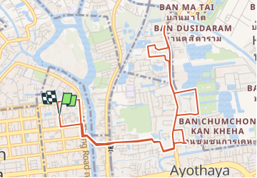
Ayutthaya - North Eastern Bicycle Track (The Northern Ayodhya Loop).gpx

an3858
Utilisateur

Longueur
8,9 km

Altitude max
13 m

Dénivelé positif
67 m
Km-Effort
9,8 km

Altitude min
0 m

Dénivelé négatif
68 m
Boucle
Oui
Date de création :
2014-12-11 00:00:00.0
Dernière modification :
2014-12-11 00:00:00.0
--
Difficulté : Inconnu

Application GPS de randonnée GRATUITE
 SityTrail
IGN / Instituts géographiques
SityTrail World
Le monde est à vous
À propos
Randonnée Vélo de 8,9 km à découvrir à จังหวัดพระนครศรีอยุธยา, อำเภอพระนครศรีอยุธยา, ตำบลหอรัตนไชย. Cette randonnée est proposée par an3858.
Points d'intérêt


Localisation
Pays :
Thaïlande
Région :
จังหวัดพระนครศรีอยุธยา
Département/Province :
อำเภอพระนครศรีอยุธยา
Commune :
ตำบลหอรัตนไชย
Localité :
Unknown
Départ:(Dec)
Départ:(UTM)
670066 ; 1588173 (47P) N.
Commentaires
Randonnées à proximité