![](/images/other/stat-length.png)
![Randonnée Randonnée équestre Les Authieux-sur-le-Port-Saint-Ouen - St Adrien - Photo](https://media.geolcdn.com/t/1900/400/ext.pjpeg?maxdim=2&url=https%3A%2F%2Fstatic1.geolcdn.com%2Fsiteimages%2Fupload%2Ffiles%2F1524743154cheval.jpg)
St Adrien
Verlainedolly2207
Utilisateur
![Longueur](/images/other/stat-length.png)
Longueur
17,8 km
![Altitude max](https://static1.geolcdn.com/siteimages/upload/files/1508320355ic_sort_altitude_max_24dp.png)
Altitude max
153 m
![Dénivelé positif](https://static1.geolcdn.com/siteimages/upload/files/1508320355ic_sort_den_pos_24dp.png)
Dénivelé positif
440 m
![Km-Effort](/images/other/stat-length.png)
Km-Effort
24 km
![Altitude min](https://static1.geolcdn.com/siteimages/upload/files/1508320355ic_sort_altitude_min_24dp.png)
Altitude min
8 m
![Dénivelé négatif](https://static1.geolcdn.com/siteimages/upload/files/1508320355ic_sort_den_neg_24dp.png)
Dénivelé négatif
440 m
![Boucle](https://static1.geolcdn.com/siteimages/upload/files/16400158638029165_repeat_loop_refresh_sync_direction_icon.png)
Boucle
Oui
Date de création :
2023-05-20 14:08:02.293
Dernière modification :
2023-05-20 14:11:32.359
![Randonnée équestre](https://static1.geolcdn.com/sitytour/trail-icons/301.png)
3h06
Difficulté : Moyen
![Scannez ce code QR pour ouvrir la randonnée dans l'application SityTrail](https://capi.geolives.com/qq0zvz2zws4bq2lad0pu/sitytour/trails/3666765/qr.png?size=200)
Application GPS de randonnée GRATUITE
À propos
Randonnée Randonnée équestre de 17,8 km à découvrir à Normandie, Seine-Maritime, Les Authieux-sur-le-Port-Saint-Ouen. Cette randonnée est proposée par Verlainedolly2207.
Description
Superbe randonnée au départ des authieux sur le port st ouen.
Vue magnifique sur Rouen et la seine.
Localisation
Pays :
France
Région :
Normandie
Département/Province :
Seine-Maritime
Commune :
Les Authieux-sur-le-Port-Saint-Ouen
Localité :
Unknown
Départ:(Dec)
Départ:(UTM)
364522 ; 5466926 (31U) N.
Commentaires
Randonnées à proximité
![Randonnée Marche Sotteville-sous-le-Val - Sotteville sous le Val vers Igoville - Photo](https://media.geolcdn.com/t/375/260/ext.jpg?maxdim=2&url=https%3A%2F%2Fservices.sitytrail.com%2FGeolivesWS%2FDownloadMedia.ashx%3FTrailID%3D954232%26Media%3Dfix__20180427145133.jpg)
![Marche Marche](https://static1.geolcdn.com/sitytour/trail-icons/101.png)
Sotteville sous le Val vers Igoville
Marche
Facile
(1)
Sotteville-sous-le-Val,
Normandie,
Seine-Maritime,
France
![](/images/other/stat-length.png)
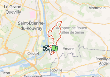
8,7 km | 9,3 km-effort
1h 48min
![](https://static1.geolcdn.com/siteimages/upload/files/16400158638029165_repeat_loop_refresh_sync_direction_icon.png)
Oui
![Randonnée Marche Oissel - 076-36-Oissel /les Essarts 13km-511-205 - Photo](https://media.geolcdn.com/t/375/260/ec83c66c-3a16-4133-93c3-fe87b7f1d0ed.jpg&format=jpg&maxdim=2)
![Marche Marche](https://static1.geolcdn.com/sitytour/trail-icons/101.png)
076-36-Oissel /les Essarts 13km-511-205
Marche
Moyen
(1)
Oissel,
Normandie,
Seine-Maritime,
France
![](/images/other/stat-length.png)
12,7 km | 15,2 km-effort
3h 19min
![](https://static1.geolcdn.com/siteimages/upload/files/16400158638029165_repeat_loop_refresh_sync_direction_icon.png)
Non
![Randonnée Marche Oissel - Oissel 13 km - Variante 5 - Photo](https://media.geolcdn.com/t/375/260/ext.jpg?maxdim=2&url=https%3A%2F%2Fstatic1.geolcdn.com%2Fsiteimages%2Fupload%2Ffiles%2F1553511878bg_sport_marche.png)
![Marche Marche](https://static1.geolcdn.com/sitytour/trail-icons/101.png)
Oissel 13 km - Variante 5
Marche
Très facile
(1)
Oissel,
Normandie,
Seine-Maritime,
France
![](/images/other/stat-length.png)
13,3 km | 15,2 km-effort
2h 35min
![](https://static1.geolcdn.com/siteimages/upload/files/16400158638029165_repeat_loop_refresh_sync_direction_icon.png)
Oui
![Randonnée Marche Oissel - Oissel 15 km - Variante N1 - Photo](https://media.geolcdn.com/t/375/260/ext.jpg?maxdim=2&url=https%3A%2F%2Fstatic1.geolcdn.com%2Fsiteimages%2Fupload%2Ffiles%2F1553511878bg_sport_marche.png)
![Marche Marche](https://static1.geolcdn.com/sitytour/trail-icons/101.png)
Oissel 15 km - Variante N1
Marche
Très facile
(1)
Oissel,
Normandie,
Seine-Maritime,
France
![](/images/other/stat-length.png)
14,9 km | 16,9 km-effort
2h 35min
![](https://static1.geolcdn.com/siteimages/upload/files/16400158638029165_repeat_loop_refresh_sync_direction_icon.png)
Oui
![Randonnée Marche Oissel - Oissel 13 km - Photo](https://media.geolcdn.com/t/375/260/ext.jpg?maxdim=2&url=https%3A%2F%2Fstatic1.geolcdn.com%2Fsiteimages%2Fupload%2Ffiles%2F1553511878bg_sport_marche.png)
![Marche Marche](https://static1.geolcdn.com/sitytour/trail-icons/101.png)
Oissel 13 km
Marche
Très facile
(1)
Oissel,
Normandie,
Seine-Maritime,
France
![](/images/other/stat-length.png)
13,6 km | 15,4 km-effort
2h 35min
![](https://static1.geolcdn.com/siteimages/upload/files/16400158638029165_repeat_loop_refresh_sync_direction_icon.png)
Oui
![Randonnée Marche Pont-de-l'Arche - Pont de l'Arche/ Les Damps (126) - Photo](https://media.geolcdn.com/t/375/260/ext.jpg?maxdim=2&url=https%3A%2F%2Fstatic1.geolcdn.com%2Fsiteimages%2Fupload%2Ffiles%2F1553511878bg_sport_marche.png)
![Marche Marche](https://static1.geolcdn.com/sitytour/trail-icons/101.png)
Pont de l'Arche/ Les Damps (126)
Marche
Moyen
(4)
Pont-de-l'Arche,
Normandie,
Eure,
France
![](/images/other/stat-length.png)
11,5 km | 13,9 km-effort
3h 3min
![](https://static1.geolcdn.com/siteimages/upload/files/16400158638029165_repeat_loop_refresh_sync_direction_icon.png)
Oui
![Randonnée Marche Ymare - Ymare - Photo](https://media.geolcdn.com/t/375/260/ext.jpg?maxdim=2&url=https%3A%2F%2Fstatic1.geolcdn.com%2Fsiteimages%2Fupload%2Ffiles%2F1553511878bg_sport_marche.png)
![Marche Marche](https://static1.geolcdn.com/sitytour/trail-icons/101.png)
Ymare
Marche
Très facile
(1)
Ymare,
Normandie,
Seine-Maritime,
France
![](/images/other/stat-length.png)
8,9 km | 10,6 km-effort
2h 0min
![](https://static1.geolcdn.com/siteimages/upload/files/16400158638029165_repeat_loop_refresh_sync_direction_icon.png)
Oui
![Randonnée Marche Les Authieux-sur-le-Port-Saint-Ouen - 076-81-les Authieux Igoville 15km-700-813 - Photo](https://media.geolcdn.com/t/375/260/acace470-e678-4207-9fe1-f083d26db0f1.jpg&format=jpg&maxdim=2)
![Marche Marche](https://static1.geolcdn.com/sitytour/trail-icons/101.png)
076-81-les Authieux Igoville 15km-700-813
Marche
Très facile
(1)
Les Authieux-sur-le-Port-Saint-Ouen,
Normandie,
Seine-Maritime,
France
![](/images/other/stat-length.png)
13,9 km | 16,5 km-effort
3h 37min
![](https://static1.geolcdn.com/siteimages/upload/files/16400158638029165_repeat_loop_refresh_sync_direction_icon.png)
Oui
![Marche Marche](https://static1.geolcdn.com/sitytour/trail-icons/101.png)
20240305-Gouy
Marche
Moyen
Les Authieux-sur-le-Port-Saint-Ouen,
Normandie,
Seine-Maritime,
France
![](/images/other/stat-length.png)
10,7 km | 13,1 km-effort
2h 35min
![](https://static1.geolcdn.com/siteimages/upload/files/16400158638029165_repeat_loop_refresh_sync_direction_icon.png)
Oui