![](/images/other/stat-length.png)
![Randonnée Marche Marche-en-Famenne - Waha DEPS - Photo](https://media.geolcdn.com/t/1900/400/ext.pjpeg?maxdim=2&url=https%3A%2F%2Fstatic1.geolcdn.com%2Fsiteimages%2Fupload%2Ffiles%2F1553511878bg_sport_marche.png)
Waha DEPS
thomarche
Utilisateur
![Longueur](/images/other/stat-length.png)
Longueur
10,2 km
![Altitude max](https://static1.geolcdn.com/siteimages/upload/files/1508320355ic_sort_altitude_max_24dp.png)
Altitude max
376 m
![Dénivelé positif](https://static1.geolcdn.com/siteimages/upload/files/1508320355ic_sort_den_pos_24dp.png)
Dénivelé positif
251 m
![Km-Effort](/images/other/stat-length.png)
Km-Effort
13,6 km
![Altitude min](https://static1.geolcdn.com/siteimages/upload/files/1508320355ic_sort_altitude_min_24dp.png)
Altitude min
281 m
![Dénivelé négatif](https://static1.geolcdn.com/siteimages/upload/files/1508320355ic_sort_den_neg_24dp.png)
Dénivelé négatif
251 m
![Boucle](https://static1.geolcdn.com/siteimages/upload/files/16400158638029165_repeat_loop_refresh_sync_direction_icon.png)
Boucle
Oui
Date de création :
2023-05-18 13:37:17.0
Dernière modification :
2023-05-18 16:04:34.379
![Marche](https://static1.geolcdn.com/sitytour/trail-icons/101.png)
2h26
Difficulté : Inconnu
![Scannez ce code QR pour ouvrir la randonnée dans l'application SityTrail](https://capi.geolives.com/qq0zvz2zws4bq2lad0pu/sitytour/trails/3664467/qr.png?size=200)
Application GPS de randonnée GRATUITE
À propos
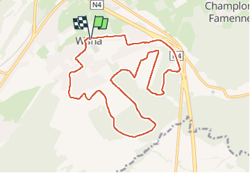
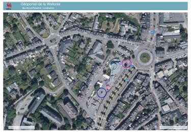
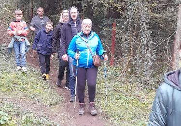
Randonnée Marche de 10,2 km à découvrir à Wallonie, Luxembourg, Marche-en-Famenne. Cette randonnée est proposée par thomarche.
Description
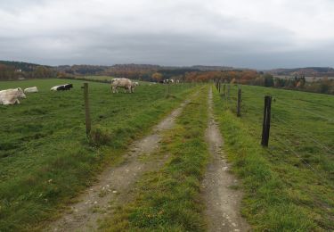
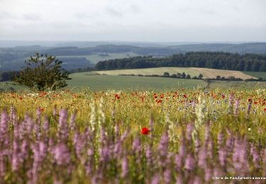
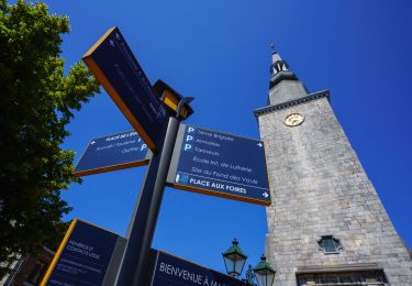
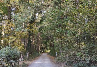
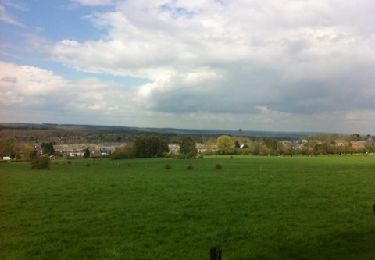
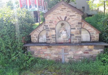
Démarrage macadam puis long N4 mais superbes chemins tout du long après. Avec vue extraordinairement large au milieu. Très belle église de Waha.
Localisation
Pays :
Belgique
Région :
Wallonie
Département/Province :
Luxembourg
Commune :
Marche-en-Famenne
Localité :
Unknown
Départ:(Dec)
Départ:(UTM)
667289 ; 5564860 (31U) N.
Commentaires
Randonnées à proximité
![Randonnée Marche Marche-en-Famenne - RB-Lu-31_Marche-en-Famenne - Photo](https://media.geolcdn.com/t/375/260/ext.jpg?maxdim=2&url=https%3A%2F%2Fmedia.geolcdn.com%2Ff%2Fa3476dbc-c577-4b1e-acc4-82c57d99db25.JPG)
![Marche Marche](https://static1.geolcdn.com/sitytour/trail-icons/101.png)
RB-Lu-31_Marche-en-Famenne
Marche
Très facile
(3)
Marche-en-Famenne,
Wallonie,
Luxembourg,
Belgique
![](/images/other/stat-length.png)
24 km | 29 km-effort
6h 10min
![](https://static1.geolcdn.com/siteimages/upload/files/16400158638029165_repeat_loop_refresh_sync_direction_icon.png)
Oui
![Randonnée Marche Marche-en-Famenne - Balade pédestre de la Hédrée - Photo](https://media.geolcdn.com/t/375/260/ext.jpg?maxdim=2&url=https%3A%2F%2Fmedia.geolcdn.com%2Ff%2Fab1d5669-7ecf-451e-a04e-4f6f7bcd2b0a.jpg)
![Marche Marche](https://static1.geolcdn.com/sitytour/trail-icons/101.png)
Balade pédestre de la Hédrée
Marche
Moyen
(2)
Marche-en-Famenne,
Wallonie,
Luxembourg,
Belgique
![](/images/other/stat-length.png)
5,7 km | 8,2 km-effort
1h 51min
![](https://static1.geolcdn.com/siteimages/upload/files/16400158638029165_repeat_loop_refresh_sync_direction_icon.png)
Oui
![Randonnée Marche Marche-en-Famenne - Balade au coeur de Marche - Photo](https://media.geolcdn.com/t/375/260/ext.jpg?maxdim=2&url=https%3A%2F%2Fmedia.geolcdn.com%2Ff%2F15b9b319-2c34-4c39-b3ee-d3f123570689.JPG)
![Marche Marche](https://static1.geolcdn.com/sitytour/trail-icons/101.png)
Balade au coeur de Marche
Marche
Facile
(1)
Marche-en-Famenne,
Wallonie,
Luxembourg,
Belgique
![](/images/other/stat-length.png)
2,8 km | 3,1 km-effort
41min
![](https://static1.geolcdn.com/siteimages/upload/files/16400158638029165_repeat_loop_refresh_sync_direction_icon.png)
Oui
![Randonnée Marche Marche-en-Famenne - Champlon - Boucle qui alterne sous-bois et vues dégagées à 360°. Larges sentiers caillouteux et un peu de macadam. - Photo](https://media.geolcdn.com/t/375/260/ext.jpg?maxdim=2&url=https%3A%2F%2Fmedia.geolcdn.com%2Ff%2Ff9518a34-3708-4717-a5a9-ec6d14ee87bd.jpg)
![Marche Marche](https://static1.geolcdn.com/sitytour/trail-icons/101.png)
Champlon - Boucle qui alterne sous-bois et vues dégagées à 360°. Larges senti...
Marche
Facile
(1)
Marche-en-Famenne,
Wallonie,
Luxembourg,
Belgique
![](/images/other/stat-length.png)
9,6 km | 12,8 km-effort
2h 23min
![](https://static1.geolcdn.com/siteimages/upload/files/16400158638029165_repeat_loop_refresh_sync_direction_icon.png)
Oui
![Randonnée Marche Marche-en-Famenne - Aye chapelle + Gerny - Photo](https://media.geolcdn.com/t/375/260/ext.jpg?maxdim=2&url=https%3A%2F%2Fservices.sitytrail.com%2FGeolivesWS%2FDownloadMedia.ashx%3FTrailID%3D122579%26Media%3D20120420144516.jpg)
![Marche Marche](https://static1.geolcdn.com/sitytour/trail-icons/101.png)
Aye chapelle + Gerny
Marche
Facile
(3)
Marche-en-Famenne,
Wallonie,
Luxembourg,
Belgique
![](/images/other/stat-length.png)
6,6 km | 8,1 km-effort
1h 33min
![](https://static1.geolcdn.com/siteimages/upload/files/16400158638029165_repeat_loop_refresh_sync_direction_icon.png)
Non
![Randonnée Marche Marche-en-Famenne - Randoguide - Photo](https://media.geolcdn.com/t/375/260/ext.jpg?maxdim=2&url=https%3A%2F%2Fservices.sitytrail.com%2FGeolivesWS%2FDownloadMedia.ashx%3FTrailID%3D116543%26Media%3D20120310173342.jpeg)
![Marche Marche](https://static1.geolcdn.com/sitytour/trail-icons/101.png)
Randoguide
Marche
Facile
(1)
Marche-en-Famenne,
Wallonie,
Luxembourg,
Belgique
![](/images/other/stat-length.png)
5,2 km | 6,5 km-effort
1h 16min
![](https://static1.geolcdn.com/siteimages/upload/files/16400158638029165_repeat_loop_refresh_sync_direction_icon.png)
Oui
![Randonnée Marche Marche-en-Famenne - Marche Adeps à Waha - Marche-en-Famenne - Photo](https://media.geolcdn.com/t/375/260/ext.jpg?maxdim=2&url=https%3A%2F%2Fmedia.geolcdn.com%2Ff%2F5c9391b2-99f3-40b9-919c-56cb51638f9c.jpeg)
![Marche Marche](https://static1.geolcdn.com/sitytour/trail-icons/101.png)
Marche Adeps à Waha - Marche-en-Famenne
Marche
Difficile
Marche-en-Famenne,
Wallonie,
Luxembourg,
Belgique
![](/images/other/stat-length.png)
10,4 km | 13,3 km-effort
4h 1min
![](https://static1.geolcdn.com/siteimages/upload/files/16400158638029165_repeat_loop_refresh_sync_direction_icon.png)
Oui
![Randonnée A pied Marche-en-Famenne - 2. Promenade Pâquerette - Photo](https://media.geolcdn.com/t/375/260/ext.jpg?maxdim=2&url=https%3A%2F%2Fmedia.geolcdn.com%2Ff%2F29b31fe7-992f-4025-89c0-5cc6e93e05df.jpeg)
![A pied A pied](https://static1.geolcdn.com/sitytour/trail-icons/100.png)
2. Promenade Pâquerette
A pied
Facile
Marche-en-Famenne,
Wallonie,
Luxembourg,
Belgique
![](/images/other/stat-length.png)
9,8 km | 11,5 km-effort
2h 36min
![](https://static1.geolcdn.com/siteimages/upload/files/16400158638029165_repeat_loop_refresh_sync_direction_icon.png)
Oui
![Randonnée A pied Marche-en-Famenne - 17. Promenade Géranium - Photo](https://media.geolcdn.com/t/375/260/ext.jpg?maxdim=2&url=https%3A%2F%2Fmedia.geolcdn.com%2Ff%2Fda6ad657-6e94-458b-8769-ca5763dde767.jpeg)
![A pied A pied](https://static1.geolcdn.com/sitytour/trail-icons/100.png)
17. Promenade Géranium
A pied
Facile
Marche-en-Famenne,
Wallonie,
Luxembourg,
Belgique
![](/images/other/stat-length.png)
8,8 km | 10,9 km-effort
2h 28min
![](https://static1.geolcdn.com/siteimages/upload/files/16400158638029165_repeat_loop_refresh_sync_direction_icon.png)
Non