Randonnée Marche Germersheim - Jakobsweg Germersheim-Offenbach - Photo
 MAD-CVW
MAD-CVW

Utilisateur

© OpenStreetMap contributors
Longueur
Longueur
27 km
Altitude max
Altitude max
159 m
Dénivelé positif
Dénivelé positif
206 m
Km-Effort
Km-Effort  
29 km
Altitude min
Altitude min
92 m
Dénivelé négatif
Dénivelé négatif
175 m
Boucle
Boucle
Non
Date de création :
2023-04-26 08:08:04.223
Dernière modification :
2023-05-14 19:13:02.994

(0 Avis)

Marche
Marche
5h25
Difficulté : Très difficile

Scannez ce code QR pour ouvrir la randonnée dans l'application SityTrail

Application GPS de randonnée GRATUITE

Logo SityTrail SityTrail

IGN / Instituts géographiques

Télécharger SityTrail sur l'App Store Télécharger SityTrail sur Google Play

Logo SityTrail SityTrail World

Le monde est à vous

Télécharger SityTrail sur l'App Store Télécharger SityTrail sur Google Play Télécharger SityTrail sur Huawei AppGallery

À propos

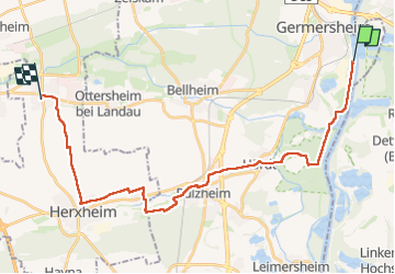
Randonnée Marche de 27 km à découvrir à Rhénanie-Palatinat, Landkreis Germersheim, Germersheim. Cette randonnée est proposée par MAD-CVW.

Description

Départ Germersheim Mitte vers Rhin, suivre chemin de halage. Dans forêt de Hoerdt suivre rectangle bleu à gauche par agréable sentier forestier jusqu'à Hoerdt. Suivre coquille vers Rülzheim puis longer ruisseau et coquille jusqu'à Herxheimweyer. sse diriger vers Herxheim,passer devant couvent puis piste cyclable vers Offenbach .

Profil altimétrique

Localisation

Pays :
Allemagne
Région :
Rhénanie-Palatinat
Département/Province :
Landkreis Germersheim
Commune :
Germersheim
Localité :
Unknown
Départ:(Dec)
Départ:(UTM)
455222 ; 5450762 (32U) N.

Randonnées à proximité

Randonnée A pied Germersheim - Rheinaue und Hochgestade - Photo
A pied
GUIDE+

A pied

Facile
Germersheim, Rhénanie-Palatinat, Landkreis Germersheim, Allemagne
4,8 km | 5,3 km-effort
1h 12min
Non
Randonnée A pied Hördt - Tulpenbaumweg - Photo
A pied
GUIDE+

A pied

Facile
Hördt, Rhénanie-Palatinat, Landkreis Germersheim, Allemagne
7,8 km | 8,7 km-effort
1h 58min
Oui
Randonnée Marche Germersheim - Vancelle enregistrer  - Photo
Marche
MAD-CVW

Marche

Très difficile
Germersheim, Rhénanie-Palatinat, Landkreis Germersheim, Allemagne
27 km | 29 km-effort
633h 53min
Non


Fermer
Mes abonnements