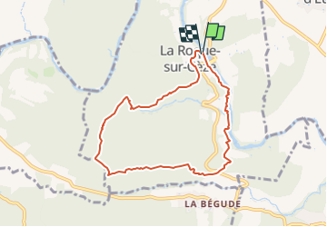
![](/images/other/stat-length.png)
![Randonnée Marche La Roque-sur-Cèze - Roque sur Cèze 8-10 km D200m - Photo](https://media.geolcdn.com/t/1900/400/ext.pjpeg?maxdim=2&url=https%3A%2F%2Fstatic1.geolcdn.com%2Fsiteimages%2Fupload%2Ffiles%2F1553511878bg_sport_marche.png)
Roque sur Cèze 8-10 km D200m
YV24
Utilisateur
![Longueur](/images/other/stat-length.png)
![Altitude max](https://static1.geolcdn.com/siteimages/upload/files/1508320355ic_sort_altitude_max_24dp.png)
![Dénivelé positif](https://static1.geolcdn.com/siteimages/upload/files/1508320355ic_sort_den_pos_24dp.png)
![Km-Effort](/images/other/stat-length.png)
![Altitude min](https://static1.geolcdn.com/siteimages/upload/files/1508320355ic_sort_altitude_min_24dp.png)
![Dénivelé négatif](https://static1.geolcdn.com/siteimages/upload/files/1508320355ic_sort_den_neg_24dp.png)
![Boucle](https://static1.geolcdn.com/siteimages/upload/files/16400158638029165_repeat_loop_refresh_sync_direction_icon.png)
![Marche](https://static1.geolcdn.com/sitytour/trail-icons/101.png)
2h22
Difficulté : Moyen
![Scannez ce code QR pour ouvrir la randonnée dans l'application SityTrail](https://capi.geolives.com/qq0zvz2zws4bq2lad0pu/sitytour/trails/3656596/qr.png?size=200)
Application GPS de randonnée GRATUITE
À propos
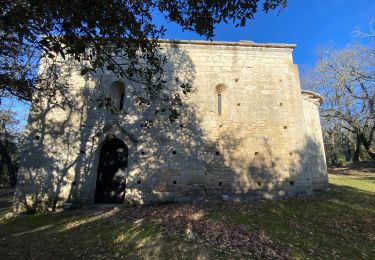
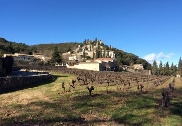
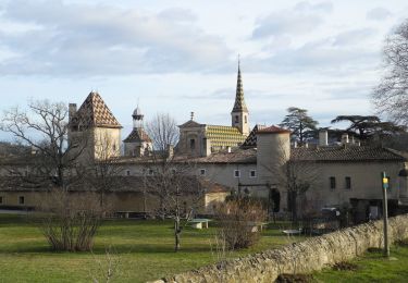
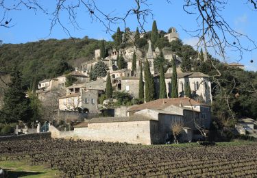
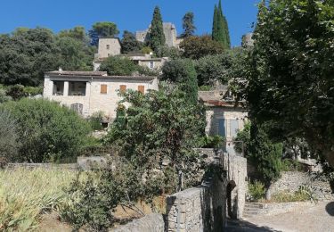
Randonnée Marche de 7,8 km à découvrir à Occitanie, Gard, La Roque-sur-Cèze. Cette randonnée est proposée par YV24.
Description
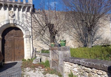
Depuis le parking au bas du village.
Variante du sympathique tracé de "alfreson".
Pas de balisage spécifique.
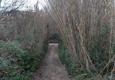
Après les remarquables cascades du Sautadet, circuit assez varié. Sentiers de causse et de maquis, souvent ombragé, pas toujours aisés, mais sans difficultés particulières. Revenir au village pour une visite agréable.
Localisation
Commentaires
Randonnées à proximité
![Randonnée Marche Saint-Michel-d'Euzet - PF-Saint-Michel-d'Euzet - La Roque-sur-Cèze - Cascade du Sautadet - Photo](https://media.geolcdn.com/t/375/260/5ffa7d08-7cf0-4f90-81fb-a51b8395d4b5.jpg&format=jpg&maxdim=2)
![Marche Marche](https://static1.geolcdn.com/sitytour/trail-icons/101.png)
Marche
![](/images/other/stat-length.png)
![](https://static1.geolcdn.com/siteimages/upload/files/16400158638029165_repeat_loop_refresh_sync_direction_icon.png)
![Marche Marche](https://static1.geolcdn.com/sitytour/trail-icons/101.png)
Marche
![](/images/other/stat-length.png)
![](https://static1.geolcdn.com/siteimages/upload/files/16400158638029165_repeat_loop_refresh_sync_direction_icon.png)
![Randonnée Marche Saint-Paulet-de-Caisson - Valbonne botaniques - Photo](https://media.geolcdn.com/t/375/260/ext.jpg?maxdim=2&url=https%3A%2F%2Fservices.sitytrail.com%2FGeolivesWS%2FDownloadMedia.ashx%3FTrailID%3D535660%26Media%3D151a24cf-2982-41bf-94a5-47441fb8f6ef.jpg)
![Marche Marche](https://static1.geolcdn.com/sitytour/trail-icons/101.png)
Marche
![](/images/other/stat-length.png)
![](https://static1.geolcdn.com/siteimages/upload/files/16400158638029165_repeat_loop_refresh_sync_direction_icon.png)
![Randonnée Marche Cornillon - Autour de Cornillon - Photo](https://media.geolcdn.com/t/375/260/387d8bc7-167b-4239-9b2d-80cd5441ef58.jpg&format=jpg&maxdim=2)
![Marche Marche](https://static1.geolcdn.com/sitytour/trail-icons/101.png)
Marche
![](/images/other/stat-length.png)
![](https://static1.geolcdn.com/siteimages/upload/files/16400158638029165_repeat_loop_refresh_sync_direction_icon.png)
![Randonnée Marche Sabran - 30 sabran - Photo](https://media.geolcdn.com/t/375/260/3928b92c-4c1a-4d3c-a8e2-58e1ffcbc7e3.jpg&format=jpg&maxdim=2)
![Marche Marche](https://static1.geolcdn.com/sitytour/trail-icons/101.png)
Marche
![](/images/other/stat-length.png)
![](https://static1.geolcdn.com/siteimages/upload/files/16400158638029165_repeat_loop_refresh_sync_direction_icon.png)
![Randonnée Marche La Roque-sur-Cèze - Village La Roque sur Cèze - Photo](https://media.geolcdn.com/t/375/260/9c55ffee-e74d-43b1-b7c1-be3835512b0a.jpg&format=jpg&maxdim=2)
![Marche Marche](https://static1.geolcdn.com/sitytour/trail-icons/101.png)
Marche
![](/images/other/stat-length.png)
![](https://static1.geolcdn.com/siteimages/upload/files/16400158638029165_repeat_loop_refresh_sync_direction_icon.png)
![Randonnée Marche Goudargues - Autour de Goudargues / Goussargues - Photo](https://media.geolcdn.com/t/375/260/956c3fb5-e313-487e-9907-67227aabb711.jpg&format=jpg&maxdim=2)
![Marche Marche](https://static1.geolcdn.com/sitytour/trail-icons/101.png)
Marche
![](/images/other/stat-length.png)
![](https://static1.geolcdn.com/siteimages/upload/files/16400158638029165_repeat_loop_refresh_sync_direction_icon.png)
![Randonnée Marche Sabran - Colombiers - Photo](https://media.geolcdn.com/t/375/260/9695fe10-84d0-4e93-a394-2b5e33a6516f.jpg&format=jpg&maxdim=2)
![Marche Marche](https://static1.geolcdn.com/sitytour/trail-icons/101.png)