![](/images/other/stat-length.png)
![Randonnée Marche nordique Lyons-la-Forêt - Marche Nordique 15 - Forêt de Lyons - RD6 - Photo](https://media.geolcdn.com/t/1900/400/ext.pjpeg?maxdim=2&url=https%3A%2F%2Fstatic1.geolcdn.com%2Fsiteimages%2Fupload%2Ffiles%2F1545311037marcheuse_200dpi.jpg)
Marche Nordique 15 - Forêt de Lyons - RD6
marcel.F
Utilisateur
![Longueur](/images/other/stat-length.png)
Longueur
9,6 km
![Altitude max](https://static1.geolcdn.com/siteimages/upload/files/1508320355ic_sort_altitude_max_24dp.png)
Altitude max
175 m
![Dénivelé positif](https://static1.geolcdn.com/siteimages/upload/files/1508320355ic_sort_den_pos_24dp.png)
Dénivelé positif
168 m
![Km-Effort](/images/other/stat-length.png)
Km-Effort
11,8 km
![Altitude min](https://static1.geolcdn.com/siteimages/upload/files/1508320355ic_sort_altitude_min_24dp.png)
Altitude min
114 m
![Dénivelé négatif](https://static1.geolcdn.com/siteimages/upload/files/1508320355ic_sort_den_neg_24dp.png)
Dénivelé négatif
168 m
![Boucle](https://static1.geolcdn.com/siteimages/upload/files/16400158638029165_repeat_loop_refresh_sync_direction_icon.png)
Boucle
Oui
Date de création :
2019-04-01 20:25:01.151
Dernière modification :
2019-04-03 10:01:56.458
![Marche nordique](https://static1.geolcdn.com/sitytour/trail-icons/102.png)
2h00
Difficulté : Moyen
![Scannez ce code QR pour ouvrir la randonnée dans l'application SityTrail](https://capi.geolives.com/qq0zvz2zws4bq2lad0pu/sitytour/trails/365131/qr.png?size=200)
Application GPS de randonnée GRATUITE
À propos
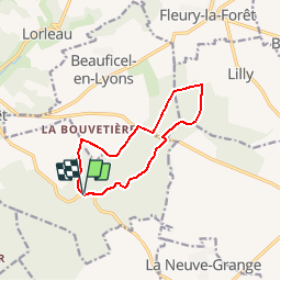
Randonnée Marche nordique de 9,6 km à découvrir à Normandie, Eure, Lyons-la-Forêt. Cette randonnée est proposée par marcel.F.
Description
Boucle marche nordique en forêt de Lyons
départ carrefour RD6 (route d'Etrépagny à Lyons la Forêt) et route de Mortemer
Localisation
Pays :
France
Région :
Normandie
Département/Province :
Eure
Commune :
Lyons-la-Forêt
Localité :
Unknown
Départ:(Dec)
Départ:(UTM)
392279 ; 5471040 (31U) N.
Commentaires
Randonnées à proximité
![Randonnée Marche Lyons-la-Forêt - Sentier de la Fontaineresse - Lyons la Forêt - Photo](https://media.geolcdn.com/t/375/260/ext.jpg?maxdim=2&url=https%3A%2F%2Fservices.sitytrail.com%2FGeolivesWS%2FDownloadMedia.ashx%3FTrailID%3D191376%26Media%3D14945_6.jpg)
![Marche Marche](https://static1.geolcdn.com/sitytour/trail-icons/101.png)
Sentier de la Fontaineresse - Lyons la Forêt
Marche
Facile
(1)
Lyons-la-Forêt,
Normandie,
Eure,
France
![](/images/other/stat-length.png)
6,3 km | 8,1 km-effort
2h 0min
![](https://static1.geolcdn.com/siteimages/upload/files/16400158638029165_repeat_loop_refresh_sync_direction_icon.png)
Oui
![Randonnée Marche nordique Beauficel-en-Lyons - Marche Nordique 85 - Carrefour d'Auteil - Forêt de Lyons - Photo](https://media.geolcdn.com/t/375/260/ext.jpg?maxdim=2&url=https%3A%2F%2Fstatic1.geolcdn.com%2Fsiteimages%2Fupload%2Ffiles%2F1545311037marcheuse_200dpi.jpg)
![Marche nordique Marche nordique](https://static1.geolcdn.com/sitytour/trail-icons/102.png)
Marche Nordique 85 - Carrefour d'Auteil - Forêt de Lyons
Marche nordique
Facile
(1)
Beauficel-en-Lyons,
Normandie,
Eure,
France
![](/images/other/stat-length.png)
9,5 km | 11,6 km-effort
1h 30min
![](https://static1.geolcdn.com/siteimages/upload/files/16400158638029165_repeat_loop_refresh_sync_direction_icon.png)
Oui
![Randonnée Marche Lyons-la-Forêt - Lyons la Forêt - Le Val Bagnard 12 - Photo](https://media.geolcdn.com/t/375/260/ext.jpg?maxdim=2&url=https%3A%2F%2Fstatic1.geolcdn.com%2Fsiteimages%2Fupload%2Ffiles%2F1553511878bg_sport_marche.png)
![Marche Marche](https://static1.geolcdn.com/sitytour/trail-icons/101.png)
Lyons la Forêt - Le Val Bagnard 12
Marche
Moyen
(1)
Lyons-la-Forêt,
Normandie,
Eure,
France
![](/images/other/stat-length.png)
12,2 km | 15,1 km-effort
2h 35min
![](https://static1.geolcdn.com/siteimages/upload/files/16400158638029165_repeat_loop_refresh_sync_direction_icon.png)
Oui
![Randonnée Marche nordique Lyons-la-Forêt - Marche Nordique 37 Lyons la Forêt - Photo](https://media.geolcdn.com/t/375/260/ext.jpg?maxdim=2&url=https%3A%2F%2Fstatic1.geolcdn.com%2Fsiteimages%2Fupload%2Ffiles%2F1545311037marcheuse_200dpi.jpg)
![Marche nordique Marche nordique](https://static1.geolcdn.com/sitytour/trail-icons/102.png)
Marche Nordique 37 Lyons la Forêt
Marche nordique
Facile
(2)
Lyons-la-Forêt,
Normandie,
Eure,
France
![](/images/other/stat-length.png)
7,8 km | 9,8 km-effort
1h 30min
![](https://static1.geolcdn.com/siteimages/upload/files/16400158638029165_repeat_loop_refresh_sync_direction_icon.png)
Oui
![Randonnée Marche nordique Lyons-la-Forêt - Marche Nordique 65 - Forêt de lyons - Photo](https://media.geolcdn.com/t/375/260/ext.jpg?maxdim=2&url=https%3A%2F%2Fstatic1.geolcdn.com%2Fsiteimages%2Fupload%2Ffiles%2F1545311037marcheuse_200dpi.jpg)
![Marche nordique Marche nordique](https://static1.geolcdn.com/sitytour/trail-icons/102.png)
Marche Nordique 65 - Forêt de lyons
Marche nordique
Facile
(1)
Lyons-la-Forêt,
Normandie,
Eure,
France
![](/images/other/stat-length.png)
8,6 km | 9,9 km-effort
Inconnu
![](https://static1.geolcdn.com/siteimages/upload/files/16400158638029165_repeat_loop_refresh_sync_direction_icon.png)
Oui
![Randonnée Marche Lyons-la-Forêt - Foret de Lyons - Les Veneurs 1 - Photo](https://media.geolcdn.com/t/375/260/ext.jpg?maxdim=2&url=https%3A%2F%2Fstatic1.geolcdn.com%2Fsiteimages%2Fupload%2Ffiles%2F1553511878bg_sport_marche.png)
![Marche Marche](https://static1.geolcdn.com/sitytour/trail-icons/101.png)
Foret de Lyons - Les Veneurs 1
Marche
Facile
(1)
Lyons-la-Forêt,
Normandie,
Eure,
France
![](/images/other/stat-length.png)
10,3 km | 12,9 km-effort
3h 13min
![](https://static1.geolcdn.com/siteimages/upload/files/16400158638029165_repeat_loop_refresh_sync_direction_icon.png)
Oui
![Randonnée Marche Lyons-la-Forêt - Foret de Lyons - Les Veneurs 2 - Photo](https://media.geolcdn.com/t/375/260/ext.jpg?maxdim=2&url=https%3A%2F%2Fstatic1.geolcdn.com%2Fsiteimages%2Fupload%2Ffiles%2F1553511878bg_sport_marche.png)
![Marche Marche](https://static1.geolcdn.com/sitytour/trail-icons/101.png)
Foret de Lyons - Les Veneurs 2
Marche
Très facile
(1)
Lyons-la-Forêt,
Normandie,
Eure,
France
![](/images/other/stat-length.png)
8,4 km | 10,9 km-effort
2h 25min
![](https://static1.geolcdn.com/siteimages/upload/files/16400158638029165_repeat_loop_refresh_sync_direction_icon.png)
Oui
![Randonnée Marche Lyons-la-Forêt - Lyons la Forêt - Le Roule - Photo](https://media.geolcdn.com/t/375/260/ext.jpg?maxdim=2&url=https%3A%2F%2Fstatic1.geolcdn.com%2Fsiteimages%2Fupload%2Ffiles%2F1553511878bg_sport_marche.png)
![Marche Marche](https://static1.geolcdn.com/sitytour/trail-icons/101.png)
Lyons la Forêt - Le Roule
Marche
Facile
(1)
Lyons-la-Forêt,
Normandie,
Eure,
France
![](/images/other/stat-length.png)
9,2 km | 12,6 km-effort
2h 31min
![](https://static1.geolcdn.com/siteimages/upload/files/16400158638029165_repeat_loop_refresh_sync_direction_icon.png)
Oui
![Randonnée Marche Lorleau - Lorleau - Saint Crespin court - Photo](https://media.geolcdn.com/t/375/260/ext.jpg?maxdim=2&url=https%3A%2F%2Fstatic1.geolcdn.com%2Fsiteimages%2Fupload%2Ffiles%2F1553511878bg_sport_marche.png)
![Marche Marche](https://static1.geolcdn.com/sitytour/trail-icons/101.png)
Lorleau - Saint Crespin court
Marche
Facile
(1)
Lorleau,
Normandie,
Eure,
France
![](/images/other/stat-length.png)
9,6 km | 11,3 km-effort
2h 28min
![](https://static1.geolcdn.com/siteimages/upload/files/16400158638029165_repeat_loop_refresh_sync_direction_icon.png)
Oui