![](/images/other/stat-length.png)
![Randonnée Marche Coxyde - 20230429 Oostduinkerke 4.2 Km - Photo](https://media.geolcdn.com/t/1900/400/3c5d7322-8ab8-4011-bd9d-4e01541f94c3.jpg&format=pjpeg&maxdim=2)
20230429 Oostduinkerke 4.2 Km
pierreh01
Utilisateur GUIDE
![Longueur](/images/other/stat-length.png)
Longueur
4,2 km
![Altitude max](https://static1.geolcdn.com/siteimages/upload/files/1508320355ic_sort_altitude_max_24dp.png)
Altitude max
21 m
![Dénivelé positif](https://static1.geolcdn.com/siteimages/upload/files/1508320355ic_sort_den_pos_24dp.png)
Dénivelé positif
36 m
![Km-Effort](/images/other/stat-length.png)
Km-Effort
4,6 km
![Altitude min](https://static1.geolcdn.com/siteimages/upload/files/1508320355ic_sort_altitude_min_24dp.png)
Altitude min
4 m
![Dénivelé négatif](https://static1.geolcdn.com/siteimages/upload/files/1508320355ic_sort_den_neg_24dp.png)
Dénivelé négatif
36 m
![Boucle](https://static1.geolcdn.com/siteimages/upload/files/16400158638029165_repeat_loop_refresh_sync_direction_icon.png)
Boucle
Oui
Date de création :
2023-04-29 14:39:38.754
Dernière modification :
2023-04-30 18:11:59.218
![Marche](https://static1.geolcdn.com/sitytour/trail-icons/101.png)
1h20
Difficulté : Facile
![Scannez ce code QR pour ouvrir la randonnée dans l'application SityTrail](https://capi.geolives.com/qq0zvz2zws4bq2lad0pu/sitytour/trails/3640216/qr.png?size=200)
Application GPS de randonnée GRATUITE
À propos
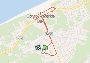
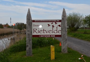
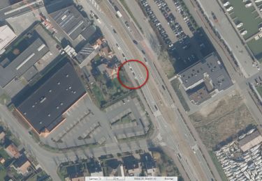
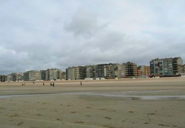
Randonnée Marche de 4,2 km à découvrir à Flandre, Flandre-Occidentale, Coxyde. Cette randonnée est proposée par pierreh01.
Description
Samedi 29 avril 2023 : Petite balade digestive.
Après un dîner de retrouvailles d'anciens militaires à KOKSIJDE 't Liefoord, réception d'une chambre à l'hôtel Rose des Sables à OOSTDUINKERKE.
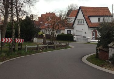
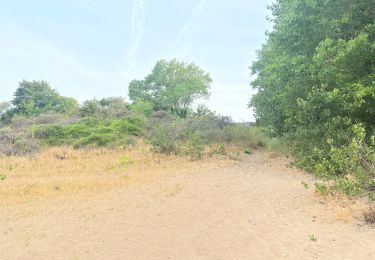
Petite balade au départ de cet hôtel jusqu'au littoral et retour.
Localisation
Pays :
Belgique
Région :
Flandre
Département/Province :
Flandre-Occidentale
Commune :
Coxyde
Localité :
Unknown
Départ:(Dec)
Départ:(UTM)
477026 ; 5663687 (31U) N.
Commentaires
Randonnées à proximité
![Randonnée Marche Coxyde - St. Idesbald et Noorduinen - Photo](https://media.geolcdn.com/t/375/260/ext.jpg?maxdim=2&url=https%3A%2F%2Fservices.sitytrail.com%2FGeolivesWS%2FDownloadMedia.ashx%3FTrailID%3D168018%26Media%3D20121231143948.jpg)
![Marche Marche](https://static1.geolcdn.com/sitytour/trail-icons/101.png)
St. Idesbald et Noorduinen
Marche
Facile
(2)
Coxyde,
Flandre,
Flandre-Occidentale,
Belgique
![](/images/other/stat-length.png)
4,5 km | 4,8 km-effort
1h 4min
![](https://static1.geolcdn.com/siteimages/upload/files/16400158638029165_repeat_loop_refresh_sync_direction_icon.png)
Oui
![Randonnée Marche Coxyde - 79.105 Oostduinkerke - Astrid- Astridwandelin - Photo](https://media.geolcdn.com/t/375/260/9479c538-170d-403d-84ed-25176d21a6e6.jpg&format=jpg&maxdim=2)
![Marche Marche](https://static1.geolcdn.com/sitytour/trail-icons/101.png)
79.105 Oostduinkerke - Astrid- Astridwandelin
Marche
Facile
(1)
Coxyde,
Flandre,
Flandre-Occidentale,
Belgique
![](/images/other/stat-length.png)
2,7 km | 3 km-effort
45min
![](https://static1.geolcdn.com/siteimages/upload/files/16400158638029165_repeat_loop_refresh_sync_direction_icon.png)
Oui
![Marche Marche](https://static1.geolcdn.com/sitytour/trail-icons/101.png)
20230504 - Nieuwpoort 8.7 Km
Marche
Facile
Coxyde,
Flandre,
Flandre-Occidentale,
Belgique
![](/images/other/stat-length.png)
8,7 km | 9,2 km-effort
2h 10min
![](https://static1.geolcdn.com/siteimages/upload/files/16400158638029165_repeat_loop_refresh_sync_direction_icon.png)
Oui
![Marche Marche](https://static1.geolcdn.com/sitytour/trail-icons/101.png)
20230504 - Nieuwpoort 8 Km
Marche
Facile
Coxyde,
Flandre,
Flandre-Occidentale,
Belgique
![](/images/other/stat-length.png)
8 km | 8,6 km-effort
2h 29min
![](https://static1.geolcdn.com/siteimages/upload/files/16400158638029165_repeat_loop_refresh_sync_direction_icon.png)
Oui
![Marche Marche](https://static1.geolcdn.com/sitytour/trail-icons/101.png)
20230503 - Sunparks Oostduinkerke 7.6 Km
Marche
Facile
Coxyde,
Flandre,
Flandre-Occidentale,
Belgique
![](/images/other/stat-length.png)
7,6 km | 8,4 km-effort
2h 13min
![](https://static1.geolcdn.com/siteimages/upload/files/16400158638029165_repeat_loop_refresh_sync_direction_icon.png)
Oui
![Randonnée Marche Nieuport - 20230430 - Nieuwpoort 10 Km - Photo](https://media.geolcdn.com/t/375/260/6594e450-9d70-498e-a6a1-346583e8bdc9.jpg&format=jpg&maxdim=2)
![Marche Marche](https://static1.geolcdn.com/sitytour/trail-icons/101.png)
20230430 - Nieuwpoort 10 Km
Marche
Facile
Nieuport,
Flandre,
Flandre-Occidentale,
Belgique
![](/images/other/stat-length.png)
10 km | 11 km-effort
4h 21min
![](https://static1.geolcdn.com/siteimages/upload/files/16400158638029165_repeat_loop_refresh_sync_direction_icon.png)
Oui
![Randonnée A pied Coxyde - IJslandvaarders - Photo](https://media.geolcdn.com/t/375/260/ff0167a3-9414-481c-8a7c-f8f5e15aac2c.jpeg&format=jpg&maxdim=2)
![A pied A pied](https://static1.geolcdn.com/sitytour/trail-icons/100.png)
IJslandvaarders
A pied
Facile
Coxyde,
Flandre,
Flandre-Occidentale,
Belgique
![](/images/other/stat-length.png)
5,3 km | 5,7 km-effort
1h 17min
![](https://static1.geolcdn.com/siteimages/upload/files/16400158638029165_repeat_loop_refresh_sync_direction_icon.png)
Oui
![Randonnée A pied Coxyde - Polderwandelroute - Photo](https://media.geolcdn.com/t/375/260/6e1733cc-250c-4f6f-a330-e197703f4186.jpeg&format=jpg&maxdim=2)
![A pied A pied](https://static1.geolcdn.com/sitytour/trail-icons/100.png)
Polderwandelroute
A pied
Facile
Coxyde,
Flandre,
Flandre-Occidentale,
Belgique
![](/images/other/stat-length.png)
13,1 km | 13,6 km-effort
3h 5min
![](https://static1.geolcdn.com/siteimages/upload/files/16400158638029165_repeat_loop_refresh_sync_direction_icon.png)
Non
![Randonnée A pied Coxyde - Artiestenwandelroute - Photo](https://media.geolcdn.com/t/375/260/54053886-9eaa-4fd8-b3ef-a405e8574e3d.jpeg&format=jpg&maxdim=2)
![A pied A pied](https://static1.geolcdn.com/sitytour/trail-icons/100.png)
Artiestenwandelroute
A pied
Facile
Coxyde,
Flandre,
Flandre-Occidentale,
Belgique
![](/images/other/stat-length.png)
9,2 km | 9,9 km-effort
2h 14min
![](https://static1.geolcdn.com/siteimages/upload/files/16400158638029165_repeat_loop_refresh_sync_direction_icon.png)
Oui