![](/images/other/stat-length.png)
![Randonnée Marche Unknown - Du monastère Gouverneto au monastère Moni Katholiko (Rother n°8) - Photo](https://media.geolcdn.com/t/1900/400/ext.pjpeg?maxdim=2&url=https%3A%2F%2Fmedia.geolcdn.com%2Ff%2Fce0a30e9-a548-4452-a3a7-2bb51d3477ee.jpg)
Du monastère Gouverneto au monastère Moni Katholiko (Rother n°8)
Bart2015
Utilisateur
![Longueur](/images/other/stat-length.png)
Longueur
4,5 km
![Altitude max](https://static1.geolcdn.com/siteimages/upload/files/1508320355ic_sort_altitude_max_24dp.png)
Altitude max
273 m
![Dénivelé positif](https://static1.geolcdn.com/siteimages/upload/files/1508320355ic_sort_den_pos_24dp.png)
Dénivelé positif
258 m
![Km-Effort](/images/other/stat-length.png)
Km-Effort
7,9 km
![Altitude min](https://static1.geolcdn.com/siteimages/upload/files/1508320355ic_sort_altitude_min_24dp.png)
Altitude min
12 m
![Dénivelé négatif](https://static1.geolcdn.com/siteimages/upload/files/1508320355ic_sort_den_neg_24dp.png)
Dénivelé négatif
259 m
![Boucle](https://static1.geolcdn.com/siteimages/upload/files/16400158638029165_repeat_loop_refresh_sync_direction_icon.png)
Boucle
Oui
Date de création :
2023-04-27 14:20:14.559
Dernière modification :
2023-05-03 18:44:30.239
![Marche](https://static1.geolcdn.com/sitytour/trail-icons/101.png)
1h45
Difficulté : Moyen
![Scannez ce code QR pour ouvrir la randonnée dans l'application SityTrail](https://capi.geolives.com/qq0zvz2zws4bq2lad0pu/sitytour/trails/3638064/qr.png?size=200)
Application GPS de randonnée GRATUITE
À propos
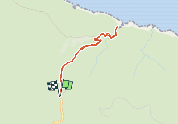
Randonnée Marche de 4,5 km à découvrir à Région Crète, Περιφερειακή Ενότητα Χανίων. Cette randonnée est proposée par Bart2015.
Description
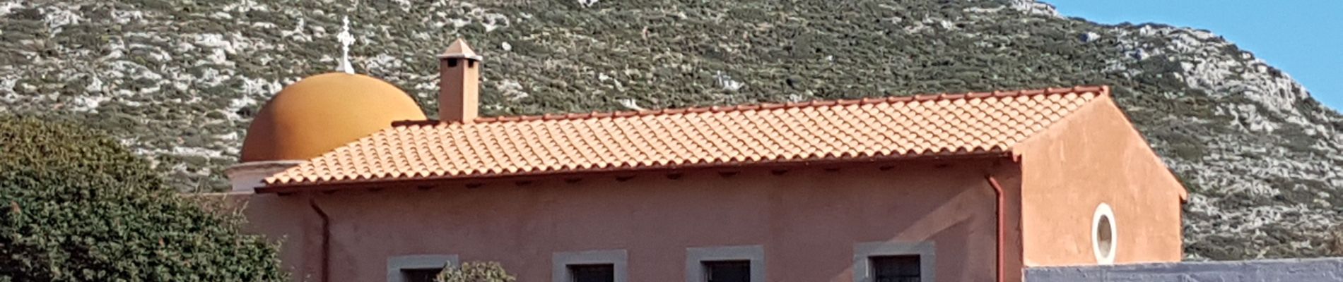
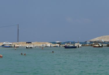
Petite balade dans la presqu'île d'Akrotiri au nord-est de Chania pour découvrir 2 monastères et entre les deux la grotte d'Arkoudiotissa. La balade d'origine est prolongée jusqu'à la mer ...
Bonne balade ...
Localisation
Pays :
Grèce
Région :
Région Crète
Département/Province :
Περιφερειακή Ενότητα Χανίων
Commune :
Unknown
Localité :
Unknown
Départ:(Dec)
Départ:(UTM)
240846 ; 3941403 (35S) N.
Commentaires
Randonnées à proximité
![Randonnée A pied - Katholiko-Stavros - Photo](https://media.geolcdn.com/t/375/260/ext.jpg?maxdim=2&url=https%3A%2F%2Fmedia.geolcdn.com%2Ff%2F86aa59bf-5ccf-4261-8400-4e974258cb19.jpeg)
![A pied A pied](https://static1.geolcdn.com/sitytour/trail-icons/100.png)
Katholiko-Stavros
A pied
Facile
,
Région Crète,
Περιφερειακή Ενότητα Χανίων,
Grèce
![](/images/other/stat-length.png)
5,8 km | 8,4 km-effort
1h 53min
![](https://static1.geolcdn.com/siteimages/upload/files/16400158638029165_repeat_loop_refresh_sync_direction_icon.png)
Non
![Randonnée Marche - Catholico - Photo](https://media.geolcdn.com/t/375/260/ext.jpg?maxdim=2&url=https%3A%2F%2Fstatic1.geolcdn.com%2Fsiteimages%2Fupload%2Ffiles%2F1553511878bg_sport_marche.png)
![Marche Marche](https://static1.geolcdn.com/sitytour/trail-icons/101.png)
Catholico
Marche
Très facile
,
Région Crète,
Περιφερειακή Ενότητα Χανίων,
Grèce
![](/images/other/stat-length.png)
4,6 km | 8,2 km-effort
2h 53min
![](https://static1.geolcdn.com/siteimages/upload/files/16400158638029165_repeat_loop_refresh_sync_direction_icon.png)
Oui
![Randonnée Marche - cave du gouverneur st jean l'ermite - Photo](https://media.geolcdn.com/t/375/260/ext.jpg?maxdim=2&url=https%3A%2F%2Fstatic1.geolcdn.com%2Fsiteimages%2Fupload%2Ffiles%2F1553511878bg_sport_marche.png)
![Marche Marche](https://static1.geolcdn.com/sitytour/trail-icons/101.png)
cave du gouverneur st jean l'ermite
Marche
Facile
,
Région Crète,
Περιφερειακή Ενότητα Χανίων,
Grèce
![](/images/other/stat-length.png)
2,5 km | 4 km-effort
1h 22min
![](https://static1.geolcdn.com/siteimages/upload/files/16400158638029165_repeat_loop_refresh_sync_direction_icon.png)
Oui