![](/images/other/stat-length.png)
![Randonnée Marche Agonac - Agonac Fontroubade variante 8km - Photo](https://media.geolcdn.com/t/1900/400/ext.pjpeg?maxdim=2&url=https%3A%2F%2Fstatic1.geolcdn.com%2Fsiteimages%2Fupload%2Ffiles%2F1553511878bg_sport_marche.png)
Agonac Fontroubade variante 8km
YV24
Utilisateur
![Longueur](/images/other/stat-length.png)
Longueur
7,9 km
![Altitude max](https://static1.geolcdn.com/siteimages/upload/files/1508320355ic_sort_altitude_max_24dp.png)
Altitude max
210 m
![Dénivelé positif](https://static1.geolcdn.com/siteimages/upload/files/1508320355ic_sort_den_pos_24dp.png)
Dénivelé positif
171 m
![Km-Effort](/images/other/stat-length.png)
Km-Effort
10,2 km
![Altitude min](https://static1.geolcdn.com/siteimages/upload/files/1508320355ic_sort_altitude_min_24dp.png)
Altitude min
112 m
![Dénivelé négatif](https://static1.geolcdn.com/siteimages/upload/files/1508320355ic_sort_den_neg_24dp.png)
Dénivelé négatif
172 m
![Boucle](https://static1.geolcdn.com/siteimages/upload/files/16400158638029165_repeat_loop_refresh_sync_direction_icon.png)
Boucle
Oui
Date de création :
2015-09-11 00:00:00.0
Dernière modification :
2015-09-11 00:00:00.0
![Marche](https://static1.geolcdn.com/sitytour/trail-icons/101.png)
2h14
Difficulté : Facile
![Scannez ce code QR pour ouvrir la randonnée dans l'application SityTrail](https://capi.geolives.com/qq0zvz2zws4bq2lad0pu/sitytour/trails/363643/qr.png?size=200)
Application GPS de randonnée GRATUITE
À propos
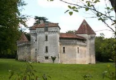
Randonnée Marche de 7,9 km à découvrir à Nouvelle-Aquitaine, Dordogne, Agonac. Cette randonnée est proposée par YV24.
Description
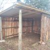
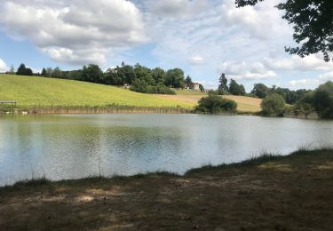
Variante du tracé selon PDIPR n°8 carte de Brantôme. Parcours varié, peu de route, praticable en tout temps, sauf en cas de débordement de la Beauronne.
Localisation
Pays :
France
Région :
Nouvelle-Aquitaine
Département/Province :
Dordogne
Commune :
Agonac
Localité :
Unknown
Départ:(Dec)
Départ:(UTM)
323644 ; 5018046 (31T) N.
Commentaires
Randonnées à proximité
![Randonnée Marche Brantôme en Périgord - Boucle Eyvirat 13 km - Photo](https://media.geolcdn.com/t/375/260/ext.jpg?maxdim=2&url=https%3A%2F%2Fstatic1.geolcdn.com%2Fsiteimages%2Fupload%2Ffiles%2F1553511878bg_sport_marche.png)
![Marche Marche](https://static1.geolcdn.com/sitytour/trail-icons/101.png)
Boucle Eyvirat 13 km
Marche
Facile
(1)
Brantôme en Périgord,
Nouvelle-Aquitaine,
Dordogne,
France
![](/images/other/stat-length.png)
13,2 km | 16,7 km-effort
3h 0min
![](https://static1.geolcdn.com/siteimages/upload/files/16400158638029165_repeat_loop_refresh_sync_direction_icon.png)
Oui
![Randonnée Marche nordique Agonac - La porte Laborie 13 km - Photo](https://media.geolcdn.com/t/375/260/ext.jpg?maxdim=2&url=https%3A%2F%2Fstatic1.geolcdn.com%2Fsiteimages%2Fupload%2Ffiles%2F1545311037marcheuse_200dpi.jpg)
![Marche nordique Marche nordique](https://static1.geolcdn.com/sitytour/trail-icons/102.png)
La porte Laborie 13 km
Marche nordique
Facile
(1)
Agonac,
Nouvelle-Aquitaine,
Dordogne,
France
![](/images/other/stat-length.png)
13,4 km | 16,3 km-effort
2h 10min
![](https://static1.geolcdn.com/siteimages/upload/files/16400158638029165_repeat_loop_refresh_sync_direction_icon.png)
Oui
![Randonnée Marche Château-l'Évêque - Preyssac - Photo](https://media.geolcdn.com/t/375/260/88e8b94c-04c3-4391-bcaf-c73b6b33a5ce.jpg&format=jpg&maxdim=2)
![Marche Marche](https://static1.geolcdn.com/sitytour/trail-icons/101.png)
Preyssac
Marche
Difficile
Château-l'Évêque,
Nouvelle-Aquitaine,
Dordogne,
France
![](/images/other/stat-length.png)
11 km | 14,5 km-effort
3h 17min
![](https://static1.geolcdn.com/siteimages/upload/files/16400158638029165_repeat_loop_refresh_sync_direction_icon.png)
Oui
![Randonnée Marche Cornille - Boucle de l étang Cornille par Pognac et Lafayardie - Photo](https://media.geolcdn.com/t/375/260/9db332a4-5555-47bf-93a5-6e867e2bdf1f.jpg&format=jpg&maxdim=2)
![Marche Marche](https://static1.geolcdn.com/sitytour/trail-icons/101.png)
Boucle de l étang Cornille par Pognac et Lafayardie
Marche
Facile
Cornille,
Nouvelle-Aquitaine,
Dordogne,
France
![](/images/other/stat-length.png)
7 km | 8,6 km-effort
2h 43min
![](https://static1.geolcdn.com/siteimages/upload/files/16400158638029165_repeat_loop_refresh_sync_direction_icon.png)
Oui
![Randonnée Marche Cornille - Boucle de Cornille - Photo](https://media.geolcdn.com/t/375/260/2cb2d33f-902e-4de3-8bf5-3cee4207e2f0.jpg&format=jpg&maxdim=2)
![Marche Marche](https://static1.geolcdn.com/sitytour/trail-icons/101.png)
Boucle de Cornille
Marche
Difficile
(1)
Cornille,
Nouvelle-Aquitaine,
Dordogne,
France
![](/images/other/stat-length.png)
12,9 km | 16,2 km-effort
3h 40min
![](https://static1.geolcdn.com/siteimages/upload/files/16400158638029165_repeat_loop_refresh_sync_direction_icon.png)
Oui
![Randonnée Vélo de route Agonac - 10km autour de la porte 56 km - Photo](https://media.geolcdn.com/t/375/260/ext.jpg?maxdim=2&url=https%3A%2F%2Fstatic1.geolcdn.com%2Fsiteimages%2Fupload%2Ffiles%2F1524743154velo.jpg)
![Vélo de route Vélo de route](https://static1.geolcdn.com/sitytour/trail-icons/201.png)
10km autour de la porte 56 km
Vélo de route
Moyen
Agonac,
Nouvelle-Aquitaine,
Dordogne,
France
![](/images/other/stat-length.png)
56 km | 66 km-effort
2h 30min
![](https://static1.geolcdn.com/siteimages/upload/files/16400158638029165_repeat_loop_refresh_sync_direction_icon.png)
Oui
![Randonnée Marche Agonac - haut d agonac - Photo](https://media.geolcdn.com/t/375/260/ext.jpg?maxdim=2&url=https%3A%2F%2Fstatic1.geolcdn.com%2Fsiteimages%2Fupload%2Ffiles%2F1553511878bg_sport_marche.png)
![Marche Marche](https://static1.geolcdn.com/sitytour/trail-icons/101.png)
haut d agonac
Marche
Très facile
Agonac,
Nouvelle-Aquitaine,
Dordogne,
France
![](/images/other/stat-length.png)
12,2 km | 15,8 km-effort
2h 59min
![](https://static1.geolcdn.com/siteimages/upload/files/16400158638029165_repeat_loop_refresh_sync_direction_icon.png)
Oui
![Randonnée Marche Saint-Front-d'Alemps - St Front d'Alemps 10km - Photo](https://media.geolcdn.com/t/375/260/ext.jpg?maxdim=2&url=https%3A%2F%2Fstatic1.geolcdn.com%2Fsiteimages%2Fupload%2Ffiles%2F1553511878bg_sport_marche.png)
![Marche Marche](https://static1.geolcdn.com/sitytour/trail-icons/101.png)
St Front d'Alemps 10km
Marche
Moyen
Saint-Front-d'Alemps,
Nouvelle-Aquitaine,
Dordogne,
France
![](/images/other/stat-length.png)
9,8 km | 11,7 km-effort
2h 33min
![](https://static1.geolcdn.com/siteimages/upload/files/16400158638029165_repeat_loop_refresh_sync_direction_icon.png)
Oui
![Randonnée Marche Brantôme en Périgord - Eyvirat 10km - Photo](https://media.geolcdn.com/t/375/260/ext.jpg?maxdim=2&url=https%3A%2F%2Fstatic1.geolcdn.com%2Fsiteimages%2Fupload%2Ffiles%2F1553511878bg_sport_marche.png)
![Marche Marche](https://static1.geolcdn.com/sitytour/trail-icons/101.png)
Eyvirat 10km
Marche
Très facile
Brantôme en Périgord,
Nouvelle-Aquitaine,
Dordogne,
France
![](/images/other/stat-length.png)
9,8 km | 12,6 km-effort
2h 45min
![](https://static1.geolcdn.com/siteimages/upload/files/16400158638029165_repeat_loop_refresh_sync_direction_icon.png)
Oui