![](/images/other/stat-length.png)
![Randonnée V.T.T. Sainte-Ode - Amberloup - Raid de la Jonquille (6) - Photo](https://media.geolcdn.com/t/1900/400/ext.pjpeg?maxdim=2&url=https%3A%2F%2Fstatic1.geolcdn.com%2Fsiteimages%2Fupload%2Ffiles%2F1524743154velo.jpg)
Amberloup - Raid de la Jonquille (6)
La Grande Forêt de Saint-Hubert
Randonnées de la Grande Forêt de Saint-Hubert GUIDE+
![Longueur](/images/other/stat-length.png)
Longueur
62 km
![Altitude max](https://static1.geolcdn.com/siteimages/upload/files/1508320355ic_sort_altitude_max_24dp.png)
Altitude max
557 m
![Dénivelé positif](https://static1.geolcdn.com/siteimages/upload/files/1508320355ic_sort_den_pos_24dp.png)
Dénivelé positif
1329 m
![Km-Effort](/images/other/stat-length.png)
Km-Effort
79 km
![Altitude min](https://static1.geolcdn.com/siteimages/upload/files/1508320355ic_sort_altitude_min_24dp.png)
Altitude min
350 m
![Dénivelé négatif](https://static1.geolcdn.com/siteimages/upload/files/1508320355ic_sort_den_neg_24dp.png)
Dénivelé négatif
1323 m
![Boucle](https://static1.geolcdn.com/siteimages/upload/files/16400158638029165_repeat_loop_refresh_sync_direction_icon.png)
Boucle
Non
Date de création :
2017-10-03 00:00:00.0
Dernière modification :
2017-10-03 00:00:00.0
![V.T.T.](https://static1.geolcdn.com/sitytour/trail-icons/202.png)
5h03
Difficulté : Très difficile
![Scannez ce code QR pour ouvrir la randonnée dans l'application SityTrail](https://capi.geolives.com/qq0zvz2zws4bq2lad0pu/sitytour/trails/363377/qr.png?size=200)
Application GPS de randonnée GRATUITE
À propos
Randonnée V.T.T. de 62 km à découvrir à Wallonie, Luxembourg, Sainte-Ode. Cette randonnée est proposée par La Grande Forêt de Saint-Hubert.
Description
Itinéraire VTT non balisé dans la commune de Sainte-Ode
Concepteur: Syndicat d'Initiative de Sainte-Ode
Localisation
Pays :
Belgique
Région :
Wallonie
Département/Province :
Luxembourg
Commune :
Sainte-Ode
Localité :
Amberloup
Départ:(Dec)
Départ:(UTM)
681122 ; 5545537 (31U) N.
Commentaires
Randonnées à proximité
![Randonnée Marche Sainte-Ode - RB-Lu-08_Amberloup_via-racc-1-2-3 - Photo](https://media.geolcdn.com/t/375/260/ext.jpg?maxdim=2&url=https%3A%2F%2Fservices.sitytrail.com%2FGeolivesWS%2FDownloadMedia.ashx%3FTrailID%3D216067%26Media%3Da5159bed-d44e-45f6-91bf-98d2633ab672.jpg)
![Marche Marche](https://static1.geolcdn.com/sitytour/trail-icons/101.png)
RB-Lu-08_Amberloup_via-racc-1-2-3
Marche
Difficile
(2)
Sainte-Ode,
Wallonie,
Luxembourg,
Belgique
![](/images/other/stat-length.png)
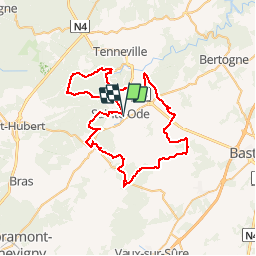
15,2 km | 18,6 km-effort
4h 13min
![](https://static1.geolcdn.com/siteimages/upload/files/16400158638029165_repeat_loop_refresh_sync_direction_icon.png)
Oui
![Randonnée Marche Sainte-Ode - Tonny - Promenade de Tonny (A6) - Photo](https://media.geolcdn.com/t/375/260/ext.jpg?maxdim=2&url=https%3A%2F%2Fservices.sitytrail.com%2FGeolivesWS%2FDownloadMedia.ashx%3FTrailID%3D470390%26Media%3D36d9826a-10d7-493f-bb50-7affdbc9817f.jpg)
![Marche Marche](https://static1.geolcdn.com/sitytour/trail-icons/101.png)
Tonny - Promenade de Tonny (A6)
Marche
Moyen
(3)
Sainte-Ode,
Wallonie,
Luxembourg,
Belgique
![](/images/other/stat-length.png)
9,5 km | 12,2 km-effort
2h 36min
![](https://static1.geolcdn.com/siteimages/upload/files/16400158638029165_repeat_loop_refresh_sync_direction_icon.png)
Oui
![Randonnée Marche Sainte-Ode - Beauplateau - Promenade du Pleurotte (T7) - Photo](https://media.geolcdn.com/t/375/260/ext.jpg?maxdim=2&url=https%3A%2F%2Fservices.sitytrail.com%2FGeolivesWS%2FDownloadMedia.ashx%3FTrailID%3D334523%26Media%3D18a8c2b6-d141-493c-b9d2-49dc585d80d8.JPG)
![Marche Marche](https://static1.geolcdn.com/sitytour/trail-icons/101.png)
Beauplateau - Promenade du Pleurotte (T7)
Marche
Moyen
(3)
Sainte-Ode,
Wallonie,
Luxembourg,
Belgique
![](/images/other/stat-length.png)
5,5 km | 6,9 km-effort
1h 29min
![](https://static1.geolcdn.com/siteimages/upload/files/16400158638029165_repeat_loop_refresh_sync_direction_icon.png)
Oui
![Randonnée Marche Sainte-Ode - Lavacherie - Promenade de la Bonne Dame (L1) - Photo](https://media.geolcdn.com/t/375/260/ext.jpg?maxdim=2&url=https%3A%2F%2Fservices.sitytrail.com%2FGeolivesWS%2FDownloadMedia.ashx%3FTrailID%3D334508%26Media%3Dbeafdf5d-7e56-47ba-baef-9d2f39d35ed9.png)
![Marche Marche](https://static1.geolcdn.com/sitytour/trail-icons/101.png)
Lavacherie - Promenade de la Bonne Dame (L1)
Marche
Moyen
(5)
Sainte-Ode,
Wallonie,
Luxembourg,
Belgique
![](/images/other/stat-length.png)
7,7 km | 10 km-effort
2h 10min
![](https://static1.geolcdn.com/siteimages/upload/files/16400158638029165_repeat_loop_refresh_sync_direction_icon.png)
Oui
![Randonnée Marche Sainte-Ode - Amberloup, Natura 2000 - Des sites qui valent le détour. Lx11 - Photo](https://media.geolcdn.com/t/375/260/ext.jpg?maxdim=2&url=https%3A%2F%2Fservices.sitytrail.com%2FGeolivesWS%2FDownloadMedia.ashx%3FTrailID%3D181909%26Media%3Dd96a433d-6654-4704-ae71-038ac1db039e.JPG)
![Marche Marche](https://static1.geolcdn.com/sitytour/trail-icons/101.png)
Amberloup, Natura 2000 - Des sites qui valent le détour. Lx11
Marche
Facile
(4)
Sainte-Ode,
Wallonie,
Luxembourg,
Belgique
![](/images/other/stat-length.png)
4,2 km | 5 km-effort
1h 6min
![](https://static1.geolcdn.com/siteimages/upload/files/16400158638029165_repeat_loop_refresh_sync_direction_icon.png)
Oui
![Randonnée Marche Sainte-Ode - RB-Lu-08_Amberloup - Photo](https://media.geolcdn.com/t/375/260/ext.jpg?maxdim=2&url=https%3A%2F%2Fservices.sitytrail.com%2FGeolivesWS%2FDownloadMedia.ashx%3FTrailID%3D179624%26Media%3D32148395-8c8d-48d3-9d07-5af495614365.jpg)
![Marche Marche](https://static1.geolcdn.com/sitytour/trail-icons/101.png)
RB-Lu-08_Amberloup
Marche
Moyen
(1)
Sainte-Ode,
Wallonie,
Luxembourg,
Belgique
![](/images/other/stat-length.png)
23 km | 29 km-effort
6h 14min
![](https://static1.geolcdn.com/siteimages/upload/files/16400158638029165_repeat_loop_refresh_sync_direction_icon.png)
Oui
![Randonnée Marche Sainte-Ode - rando lavacherie 5-02-2022 - Photo](https://media.geolcdn.com/t/375/260/51d83bb4-0870-46ee-b60b-b2146d049ac2.jpg&format=jpg&maxdim=2)
![Marche Marche](https://static1.geolcdn.com/sitytour/trail-icons/101.png)
rando lavacherie 5-02-2022
Marche
Moyen
(1)
Sainte-Ode,
Wallonie,
Luxembourg,
Belgique
![](/images/other/stat-length.png)
8,6 km | 12,1 km-effort
2h 17min
![](https://static1.geolcdn.com/siteimages/upload/files/16400158638029165_repeat_loop_refresh_sync_direction_icon.png)
Oui
![Randonnée Marche Sainte-Ode - rando lavacherie 29/08/2020 - Photo](https://media.geolcdn.com/t/375/260/748c1b0e-fc3a-4c4c-86ea-3c557994f8d1.jpg&format=jpg&maxdim=2)
![Marche Marche](https://static1.geolcdn.com/sitytour/trail-icons/101.png)
rando lavacherie 29/08/2020
Marche
Moyen
(1)
Sainte-Ode,
Wallonie,
Luxembourg,
Belgique
![](/images/other/stat-length.png)
15,3 km | 20 km-effort
3h 15min
![](https://static1.geolcdn.com/siteimages/upload/files/16400158638029165_repeat_loop_refresh_sync_direction_icon.png)
Oui
![Randonnée A pied Sainte-Ode - Sainte-ode - Photo](https://media.geolcdn.com/t/375/260/176a04b2-22ff-4a89-b268-e407ad0ae248.jpg&format=jpg&maxdim=2)
![A pied A pied](https://static1.geolcdn.com/sitytour/trail-icons/100.png)
Sainte-ode
A pied
Facile
(3)
Sainte-Ode,
Wallonie,
Luxembourg,
Belgique
![](/images/other/stat-length.png)
8,9 km | 11,9 km-effort
Inconnu
![](https://static1.geolcdn.com/siteimages/upload/files/16400158638029165_repeat_loop_refresh_sync_direction_icon.png)
Oui