![](/images/other/stat-length.png)
![Randonnée Marche Meerssen - Meerssen_805 - Photo](https://media.geolcdn.com/t/1900/400/ext.pjpeg?maxdim=2&url=https%3A%2F%2Fstatic1.geolcdn.com%2Fsiteimages%2Fupload%2Ffiles%2F1553511878bg_sport_marche.png)
Meerssen_805
mumu.larandonneuse
Utilisateur GUIDE
![Longueur](/images/other/stat-length.png)
![Altitude max](https://static1.geolcdn.com/siteimages/upload/files/1508320355ic_sort_altitude_max_24dp.png)
![Dénivelé positif](https://static1.geolcdn.com/siteimages/upload/files/1508320355ic_sort_den_pos_24dp.png)
![Km-Effort](/images/other/stat-length.png)
![Altitude min](https://static1.geolcdn.com/siteimages/upload/files/1508320355ic_sort_altitude_min_24dp.png)
![Dénivelé négatif](https://static1.geolcdn.com/siteimages/upload/files/1508320355ic_sort_den_neg_24dp.png)
![Boucle](https://static1.geolcdn.com/siteimages/upload/files/16400158638029165_repeat_loop_refresh_sync_direction_icon.png)
![Marche](https://static1.geolcdn.com/sitytour/trail-icons/101.png)
3h25
Difficulté : Moyen
![Scannez ce code QR pour ouvrir la randonnée dans l'application SityTrail](https://capi.geolives.com/qq0zvz2zws4bq2lad0pu/sitytour/trails/3629599/qr.png?size=200)
Application GPS de randonnée GRATUITE
À propos
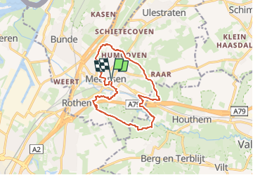
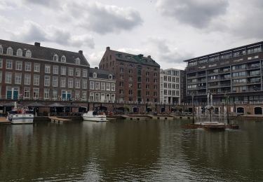
Randonnée Marche de 12,2 km à découvrir à Limbourg, Inconnu, Meerssen. Cette randonnée est proposée par mumu.larandonneuse.
Description
ℹ www.wandelgidszuidlimburg.com n° 805.
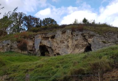
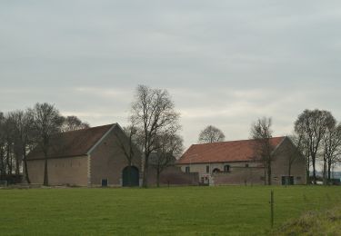
➡️ Au cours de cette balade vallonnée et variée, vous emprunterez de jolis sentiers à travers le Kalverbosch jusqu'au hameau de Humcoven. Par une route tranquille, vous marchez jusqu'au Geuldal, puis vous montez jusqu'à un magnifique point de vue avec vue sur le profond Curfsgroeve. Sur le chemin du retour, vous traversez les bois de la réserve naturelle de Dellen et un beau tronçon le long de la Gueule sinueuse. Enfin, vous traversez le magnifique parc Proosdij. Apportez vos propres provisions, après 8 km il y a un banc au-dessus de la carrière. Au bout se trouve une belle terrasse.
Localisation
Commentaires
Randonnées à proximité
![Randonnée Marche Valkenburg aan de Geul - Route-des-vins-berg-en-terblijt--houthem-st-gerlach-vi6 - Photo](https://media.geolcdn.com/t/375/260/852c106e-818c-4548-acc4-e956e65bf915.jpg&format=jpg&maxdim=2)
![Marche Marche](https://static1.geolcdn.com/sitytour/trail-icons/101.png)
Marche
![](/images/other/stat-length.png)
![](https://static1.geolcdn.com/siteimages/upload/files/16400158638029165_repeat_loop_refresh_sync_direction_icon.png)
![Randonnée Marche Maastricht - Maastricht_1693. - Photo](https://media.geolcdn.com/t/375/260/35d0d485-5909-42ec-b3f4-9d96e17c2c7d.jpg&format=jpg&maxdim=2)
![Marche Marche](https://static1.geolcdn.com/sitytour/trail-icons/101.png)
Marche
![](/images/other/stat-length.png)
![](https://static1.geolcdn.com/siteimages/upload/files/16400158638029165_repeat_loop_refresh_sync_direction_icon.png)
![Randonnée Marche Valkenburg aan de Geul - Sibbe - Valkenburg 🎄🎅 - Photo](https://media.geolcdn.com/t/375/260/635f6fea-be0e-416f-bbe0-3fc5facaae54.jpg&format=jpg&maxdim=2)
![Marche Marche](https://static1.geolcdn.com/sitytour/trail-icons/101.png)
Marche
![](/images/other/stat-length.png)
![](https://static1.geolcdn.com/siteimages/upload/files/16400158638029165_repeat_loop_refresh_sync_direction_icon.png)
![Randonnée Marche Maastricht - Maastricht - Hoge Fronten & 't Bassin - Photo](https://media.geolcdn.com/t/375/260/0d1db1de-c9bf-433a-9df4-c07031a55999.jpg&format=jpg&maxdim=2)
![Marche Marche](https://static1.geolcdn.com/sitytour/trail-icons/101.png)
Marche
![](/images/other/stat-length.png)
![](https://static1.geolcdn.com/siteimages/upload/files/16400158638029165_repeat_loop_refresh_sync_direction_icon.png)
![Randonnée Marche Maastricht - Maastricht _1087 - Photo](https://media.geolcdn.com/t/375/260/23f3cb69-ec7d-4156-85e2-e9b9420f412b.jpg&format=jpg&maxdim=2)
![Marche Marche](https://static1.geolcdn.com/sitytour/trail-icons/101.png)
Marche
![](/images/other/stat-length.png)
![](https://static1.geolcdn.com/siteimages/upload/files/16400158638029165_repeat_loop_refresh_sync_direction_icon.png)
![Randonnée Marche Eijsden-Margraten - Bemelen - Photo](https://media.geolcdn.com/t/375/260/80eebd30-fb74-4ca3-902d-6de0a7861089.jpg&format=jpg&maxdim=2)
![Marche Marche](https://static1.geolcdn.com/sitytour/trail-icons/101.png)
Marche
![](/images/other/stat-length.png)
![](https://static1.geolcdn.com/siteimages/upload/files/16400158638029165_repeat_loop_refresh_sync_direction_icon.png)
![Randonnée A pied Beekdaelen - Zevenmijlslaarzenroute - Photo](https://media.geolcdn.com/t/375/260/dev_1fdcc12b-c712-40a2-acfe-86dd1f2376f2.jpeg&format=jpg&maxdim=2)
![A pied A pied](https://static1.geolcdn.com/sitytour/trail-icons/100.png)
A pied
![](/images/other/stat-length.png)
![](https://static1.geolcdn.com/siteimages/upload/files/16400158638029165_repeat_loop_refresh_sync_direction_icon.png)
![Randonnée A pied Beek - Rondje Genhout - Photo](https://media.geolcdn.com/t/375/260/abb5d7e1-7a3a-42b7-bbd5-5c0d66587d99.jpeg&format=jpg&maxdim=2)
![A pied A pied](https://static1.geolcdn.com/sitytour/trail-icons/100.png)
![Randonnée A pied Beek - Genhoutroute - Photo](https://media.geolcdn.com/t/375/260/abb5d7e1-7a3a-42b7-bbd5-5c0d66587d99.jpeg&format=jpg&maxdim=2)
![A pied A pied](https://static1.geolcdn.com/sitytour/trail-icons/100.png)
Superbe rando.