![](/images/other/stat-length.png)
![Randonnée Marche Correns - gpx-trace CORRENS N4 - Photo](https://media.geolcdn.com/t/1900/400/ext.pjpeg?maxdim=2&url=https%3A%2F%2Fstatic1.geolcdn.com%2Fsiteimages%2Fupload%2Ffiles%2F1553511878bg_sport_marche.png)
gpx-trace CORRENS N4
azzogege
Utilisateur
![Longueur](/images/other/stat-length.png)
Longueur
15,7 km
![Altitude max](https://static1.geolcdn.com/siteimages/upload/files/1508320355ic_sort_altitude_max_24dp.png)
Altitude max
337 m
![Dénivelé positif](https://static1.geolcdn.com/siteimages/upload/files/1508320355ic_sort_den_pos_24dp.png)
Dénivelé positif
358 m
![Km-Effort](/images/other/stat-length.png)
Km-Effort
20 km
![Altitude min](https://static1.geolcdn.com/siteimages/upload/files/1508320355ic_sort_altitude_min_24dp.png)
Altitude min
160 m
![Dénivelé négatif](https://static1.geolcdn.com/siteimages/upload/files/1508320355ic_sort_den_neg_24dp.png)
Dénivelé négatif
358 m
![Boucle](https://static1.geolcdn.com/siteimages/upload/files/16400158638029165_repeat_loop_refresh_sync_direction_icon.png)
Boucle
Oui
Date de création :
2023-04-21 05:41:37.133
Dernière modification :
2024-03-10 14:09:57.796
![Marche](https://static1.geolcdn.com/sitytour/trail-icons/101.png)
4h39
Difficulté : Très difficile
![Scannez ce code QR pour ouvrir la randonnée dans l'application SityTrail](https://capi.geolives.com/qq0zvz2zws4bq2lad0pu/sitytour/trails/3629409/qr.png?size=200)
Application GPS de randonnée GRATUITE
À propos
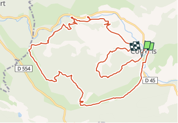
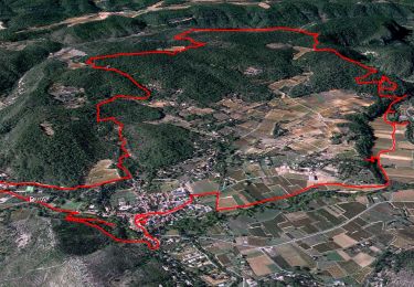
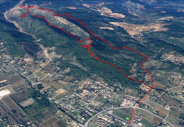
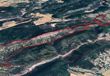
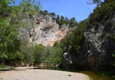
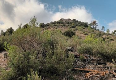
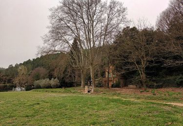
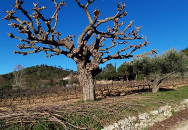
Randonnée Marche de 15,7 km à découvrir à Provence-Alpes-Côte d'Azur, Var, Correns. Cette randonnée est proposée par azzogege.
Description
trace corrige passant au depart par le chemin faisant decouvrir le village et le fort GIBRON et reprise de l'itineraire par le trace original et passage par la grotte de sous ville
Localisation
Pays :
France
Région :
Provence-Alpes-Côte d'Azur
Département/Province :
Var
Commune :
Correns
Localité :
Unknown
Départ:(Dec)
Départ:(UTM)
263913 ; 4818937 (32T) N.
Commentaires
Randonnées à proximité
![Randonnée Marche Correns - Le patrimoine - l'Argens - Le village - Photo](https://media.geolcdn.com/t/375/260/405a713c-9f67-402a-9b2f-998d4bced48b.jpg&format=jpg&maxdim=2)
![Marche Marche](https://static1.geolcdn.com/sitytour/trail-icons/101.png)
Le patrimoine - l'Argens - Le village
Marche
Facile
(2)
Correns,
Provence-Alpes-Côte d'Azur,
Var,
France
![](/images/other/stat-length.png)
14,2 km | 18,1 km-effort
6h 0min
![](https://static1.geolcdn.com/siteimages/upload/files/16400158638029165_repeat_loop_refresh_sync_direction_icon.png)
Oui
![Randonnée Marche Le Val - Les 4 chapelles - Le Cuit - Photo](https://media.geolcdn.com/t/375/260/ad8ed400-7110-4a48-9445-b211f10f638d.jpg&format=jpg&maxdim=2)
![Marche Marche](https://static1.geolcdn.com/sitytour/trail-icons/101.png)
Les 4 chapelles - Le Cuit
Marche
Moyen
(1)
Le Val,
Provence-Alpes-Côte d'Azur,
Var,
France
![](/images/other/stat-length.png)
14,6 km | 21 km-effort
6h 0min
![](https://static1.geolcdn.com/siteimages/upload/files/16400158638029165_repeat_loop_refresh_sync_direction_icon.png)
Oui
![Randonnée Marche Le Val - Le Mont Cuit par la Grande Muraille - Photo](https://media.geolcdn.com/t/375/260/9fec4f0b-b6f3-462f-8d34-0edd3ef3698e.jpg&format=jpg&maxdim=2)
![Marche Marche](https://static1.geolcdn.com/sitytour/trail-icons/101.png)
Le Mont Cuit par la Grande Muraille
Marche
Moyen
(1)
Le Val,
Provence-Alpes-Côte d'Azur,
Var,
France
![](/images/other/stat-length.png)
14 km | 21 km-effort
6h 0min
![](https://static1.geolcdn.com/siteimages/upload/files/16400158638029165_repeat_loop_refresh_sync_direction_icon.png)
Oui
![Marche Marche](https://static1.geolcdn.com/sitytour/trail-icons/101.png)
Correns - Val Obscur - Rive de l'Argens - Grotte aux Fées - Châteauvert - Val...
Marche
Moyen
Correns,
Provence-Alpes-Côte d'Azur,
Var,
France
![](/images/other/stat-length.png)
21 km | 27 km-effort
4h 57min
![](https://static1.geolcdn.com/siteimages/upload/files/16400158638029165_repeat_loop_refresh_sync_direction_icon.png)
Oui
![Randonnée Marche Le Val - circuit des chapelles-le Val-07-09-22 - Photo](https://media.geolcdn.com/t/375/260/44ac00a3-6144-4a54-9a47-ced322186cfc.jpg&format=jpg&maxdim=2)
![Marche Marche](https://static1.geolcdn.com/sitytour/trail-icons/101.png)
circuit des chapelles-le Val-07-09-22
Marche
Moyen
(1)
Le Val,
Provence-Alpes-Côte d'Azur,
Var,
France
![](/images/other/stat-length.png)
14,7 km | 22 km-effort
4h 12min
![](https://static1.geolcdn.com/siteimages/upload/files/16400158638029165_repeat_loop_refresh_sync_direction_icon.png)
Oui
![Randonnée Marche Correns - Correns-18-03-22 - Photo](https://media.geolcdn.com/t/375/260/09a33764-10f5-4925-96d0-198bf65221a1.jpg&format=jpg&maxdim=2)
![Marche Marche](https://static1.geolcdn.com/sitytour/trail-icons/101.png)
Correns-18-03-22
Marche
Moyen
Correns,
Provence-Alpes-Côte d'Azur,
Var,
France
![](/images/other/stat-length.png)
11,9 km | 14,9 km-effort
4h 10min
![](https://static1.geolcdn.com/siteimages/upload/files/16400158638029165_repeat_loop_refresh_sync_direction_icon.png)
Oui
![Randonnée Marche Le Val - Circuit des Chapelle-Le Val-15-01-21 - Photo](https://media.geolcdn.com/t/375/260/e4c20b6b-c67f-4f8a-9d83-5af46fcebc22.jpg&format=jpg&maxdim=2)
![Marche Marche](https://static1.geolcdn.com/sitytour/trail-icons/101.png)
Circuit des Chapelle-Le Val-15-01-21
Marche
Moyen
(1)
Le Val,
Provence-Alpes-Côte d'Azur,
Var,
France
![](/images/other/stat-length.png)
12,7 km | 18,1 km-effort
4h 29min
![](https://static1.geolcdn.com/siteimages/upload/files/16400158638029165_repeat_loop_refresh_sync_direction_icon.png)
Oui
![Randonnée Marche Le Val - Le Val : Le Cuit - Photo](https://media.geolcdn.com/t/375/260/ext.jpg?maxdim=2&url=https%3A%2F%2Fstatic1.geolcdn.com%2Fsiteimages%2Fupload%2Ffiles%2F1553511878bg_sport_marche.png)
![Marche Marche](https://static1.geolcdn.com/sitytour/trail-icons/101.png)
Le Val : Le Cuit
Marche
Difficile
(1)
Le Val,
Provence-Alpes-Côte d'Azur,
Var,
France
![](/images/other/stat-length.png)
12,9 km | 19,8 km-effort
4h 7min
![](https://static1.geolcdn.com/siteimages/upload/files/16400158638029165_repeat_loop_refresh_sync_direction_icon.png)
Oui
![Randonnée V.T.T. Correns - Correns à faire - Photo](https://media.geolcdn.com/t/375/260/6347d8bc-2d08-4062-9163-62c8d555de14.jpg&format=jpg&maxdim=2)
![V.T.T. V.T.T.](https://static1.geolcdn.com/sitytour/trail-icons/202.png)
Correns à faire
V.T.T.
Moyen
Correns,
Provence-Alpes-Côte d'Azur,
Var,
France
![](/images/other/stat-length.png)
25 km | 32 km-effort
2h 55min
![](https://static1.geolcdn.com/siteimages/upload/files/16400158638029165_repeat_loop_refresh_sync_direction_icon.png)
Oui