![](/images/other/stat-length.png)
![Randonnée Marche Bages - Bages d'Aude, les Pesquis - Photo](https://media.geolcdn.com/t/1900/400/ext.pjpeg?maxdim=2&url=https%3A%2F%2Fstatic1.geolcdn.com%2Fsiteimages%2Fupload%2Ffiles%2F1553511878bg_sport_marche.png)
Bages d'Aude, les Pesquis
Santblasi
Utilisateur
![Longueur](/images/other/stat-length.png)
![Altitude max](https://static1.geolcdn.com/siteimages/upload/files/1508320355ic_sort_altitude_max_24dp.png)
![Dénivelé positif](https://static1.geolcdn.com/siteimages/upload/files/1508320355ic_sort_den_pos_24dp.png)
![Km-Effort](/images/other/stat-length.png)
![Altitude min](https://static1.geolcdn.com/siteimages/upload/files/1508320355ic_sort_altitude_min_24dp.png)
![Dénivelé négatif](https://static1.geolcdn.com/siteimages/upload/files/1508320355ic_sort_den_neg_24dp.png)
![Boucle](https://static1.geolcdn.com/siteimages/upload/files/16400158638029165_repeat_loop_refresh_sync_direction_icon.png)
![Marche](https://static1.geolcdn.com/sitytour/trail-icons/101.png)
3h13
Difficulté : Facile
![Scannez ce code QR pour ouvrir la randonnée dans l'application SityTrail](https://capi.geolives.com/qq0zvz2zws4bq2lad0pu/sitytour/trails/3624960/qr.png?size=200)
Application GPS de randonnée GRATUITE
À propos
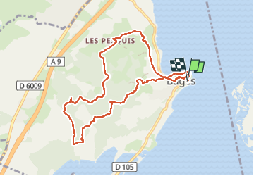
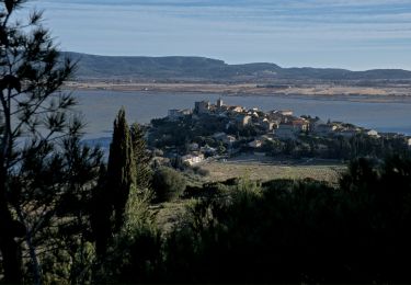
Randonnée Marche de 10,3 km à découvrir à Occitanie, Aude, Bages. Cette randonnée est proposée par Santblasi.
Description
parking le long de l'étang, en bas du village.
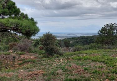
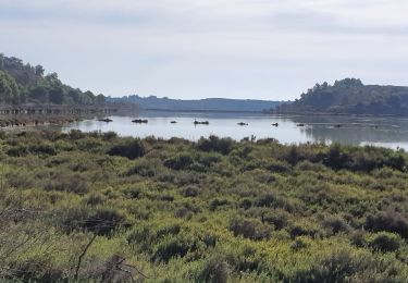
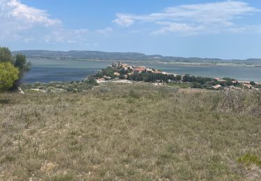
contourner Bages, grimper en haut du Pech Crouchet. Vues sur étangs et le village.
Descente vers la route qui passe à Estarac. S'engager dans la Combe Vieille
pour continuer sur une belle montée et arriver au sommet de la colline puis descendre au village des Pesquis.
passage à la fontaine de Bajole, tarie,
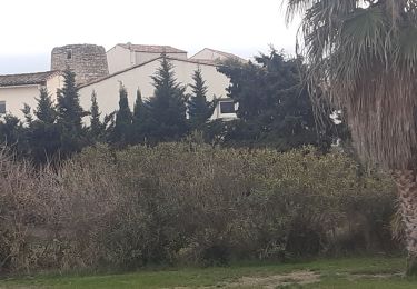
retour au village avec son église et retrouver le parking.
Localisation
Commentaires
Randonnées à proximité
![Randonnée Marche Narbonne - La Clape - Trou de la Crouzade - Photo](https://media.geolcdn.com/t/375/260/ea735574-5c3a-4f69-8ed7-e5ff48f9dc4c.jpg&format=jpg&maxdim=2)
![Marche Marche](https://static1.geolcdn.com/sitytour/trail-icons/101.png)
Marche
![](/images/other/stat-length.png)
![](https://static1.geolcdn.com/siteimages/upload/files/16400158638029165_repeat_loop_refresh_sync_direction_icon.png)
![Randonnée Marche Narbonne - Port la Nautique - Photo](https://media.geolcdn.com/t/375/260/f1dc1b5e-e4aa-42a2-b591-bf12619738fc.jpg&format=jpg&maxdim=2)
![Marche Marche](https://static1.geolcdn.com/sitytour/trail-icons/101.png)
![Randonnée Marche Bages - BAGES - SOURCE DE BAJOLE - POINT DE VUE A L OLIVET 9.8KMS 2h41 - Photo](https://media.geolcdn.com/t/375/260/ext.jpg?maxdim=2&url=https%3A%2F%2Fstatic1.geolcdn.com%2Fsiteimages%2Fupload%2Ffiles%2F1553511878bg_sport_marche.png)
![Marche Marche](https://static1.geolcdn.com/sitytour/trail-icons/101.png)
Marche
![](/images/other/stat-length.png)
![](https://static1.geolcdn.com/siteimages/upload/files/16400158638029165_repeat_loop_refresh_sync_direction_icon.png)
![Randonnée Marche Peyriac-de-Mer - peyriac bages peyriac - Photo](https://media.geolcdn.com/t/375/260/4e7857ab-3da4-4579-be68-eab06d888ebf.jpg&format=jpg&maxdim=2)
![Marche Marche](https://static1.geolcdn.com/sitytour/trail-icons/101.png)
Marche
![](/images/other/stat-length.png)
![](https://static1.geolcdn.com/siteimages/upload/files/16400158638029165_repeat_loop_refresh_sync_direction_icon.png)
![Randonnée Marche Narbonne - La combe d'enfer en Narbonnais - Photo](https://media.geolcdn.com/t/375/260/28cc313a-8a47-482c-81b5-28081d16a224.jpg&format=jpg&maxdim=2)
![Marche Marche](https://static1.geolcdn.com/sitytour/trail-icons/101.png)
Marche
![](/images/other/stat-length.png)
![](https://static1.geolcdn.com/siteimages/upload/files/16400158638029165_repeat_loop_refresh_sync_direction_icon.png)
![Randonnée Marche Peyriac-de-Mer - PEYRIAC DE MER en boucle - Photo](https://media.geolcdn.com/t/375/260/ebbf8f3d-cec9-4ce2-95b9-a7ad43ef2a83.jpg&format=jpg&maxdim=2)
![Marche Marche](https://static1.geolcdn.com/sitytour/trail-icons/101.png)
Marche
![](/images/other/stat-length.png)
![](https://static1.geolcdn.com/siteimages/upload/files/16400158638029165_repeat_loop_refresh_sync_direction_icon.png)
![Randonnée Marche Bages - Nages d’Aude - Photo](https://media.geolcdn.com/t/375/260/9a574c14-2c6d-48d7-8d17-a80e8738a083.jpg&format=jpg&maxdim=2)
![Marche Marche](https://static1.geolcdn.com/sitytour/trail-icons/101.png)
![Randonnée Marche Peyriac-de-Mer - peyriac de mer . étang de doul . roc de vidal . pêche rouge . croix St Paul. peyriac - Photo](https://media.geolcdn.com/t/375/260/3df76c5b-37e4-463d-aabf-a4155f686d68.jpg&format=jpg&maxdim=2)
![Marche Marche](https://static1.geolcdn.com/sitytour/trail-icons/101.png)
Marche
![](/images/other/stat-length.png)
![](https://static1.geolcdn.com/siteimages/upload/files/16400158638029165_repeat_loop_refresh_sync_direction_icon.png)
![Randonnée Marche Bages - Boucle de Bages à Peyrac-de-Mer - Photo](https://media.geolcdn.com/t/375/260/ab0d61f3-4a50-4876-a7cc-26d36bfb2d3e.jpg&format=jpg&maxdim=2)
![Marche Marche](https://static1.geolcdn.com/sitytour/trail-icons/101.png)
Marche
![](/images/other/stat-length.png)
![](https://static1.geolcdn.com/siteimages/upload/files/16400158638029165_repeat_loop_refresh_sync_direction_icon.png)