![](/images/other/stat-length.png)
![Randonnée Marche Niederbronn-les-Bains - SityTrail - RBR ign camp celtique - Photo](https://media.geolcdn.com/t/1900/400/ext.pjpeg?maxdim=2&url=https%3A%2F%2Fstatic1.geolcdn.com%2Fsiteimages%2Fupload%2Ffiles%2F1553511878bg_sport_marche.png)
SityTrail - RBR ign camp celtique
Dominique Baudelocque
Utilisateur
![Longueur](/images/other/stat-length.png)
Longueur
1,6 km
![Altitude max](https://static1.geolcdn.com/siteimages/upload/files/1508320355ic_sort_altitude_max_24dp.png)
Altitude max
494 m
![Dénivelé positif](https://static1.geolcdn.com/siteimages/upload/files/1508320355ic_sort_den_pos_24dp.png)
Dénivelé positif
14 m
![Km-Effort](/images/other/stat-length.png)
Km-Effort
1,9 km
![Altitude min](https://static1.geolcdn.com/siteimages/upload/files/1508320355ic_sort_altitude_min_24dp.png)
Altitude min
438 m
![Dénivelé négatif](https://static1.geolcdn.com/siteimages/upload/files/1508320355ic_sort_den_neg_24dp.png)
Dénivelé négatif
57 m
![Boucle](https://static1.geolcdn.com/siteimages/upload/files/16400158638029165_repeat_loop_refresh_sync_direction_icon.png)
Boucle
Non
Date de création :
2023-04-16 19:19:50.336
Dernière modification :
2023-04-16 19:31:33.693
![Marche](https://static1.geolcdn.com/sitytour/trail-icons/101.png)
26m
Difficulté : Facile
![Scannez ce code QR pour ouvrir la randonnée dans l'application SityTrail](https://capi.geolives.com/qq0zvz2zws4bq2lad0pu/sitytour/trails/3624328/qr.png?size=200)
Application GPS de randonnée GRATUITE
À propos
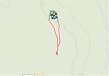
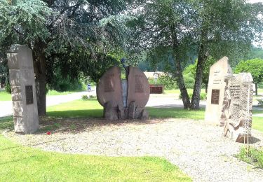
Randonnée Marche de 1,6 km à découvrir à Grand Est, Bas-Rhin, Niederbronn-les-Bains. Cette randonnée est proposée par Dominique Baudelocque .
Description
Trace gpx rectangle rouge-blanc-rouge sur crête (existe sur carte IGN) et sous crête (inexistant sur carte IGN).
Localisation
Pays :
France
Région :
Grand Est
Département/Province :
Bas-Rhin
Commune :
Niederbronn-les-Bains
Localité :
Unknown
Départ:(Dec)
Départ:(UTM)
398771 ; 5425674 (32U) N.
Commentaires
Randonnées à proximité
![Randonnée Marche Oberbronn - En forêt de Niederbronn de Oberbronn au château de Wasenbourg - Photo](https://media.geolcdn.com/t/375/260/ext.jpg?maxdim=2&url=https%3A%2F%2Fservices.sitytrail.com%2FGeolivesWS%2FDownloadMedia.ashx%3FTrailID%3D317705%26Media%3D17009_6.jpg)
![Marche Marche](https://static1.geolcdn.com/sitytour/trail-icons/101.png)
En forêt de Niederbronn de Oberbronn au château de Wasenbourg
Marche
Moyen
(1)
Oberbronn,
Grand Est,
Bas-Rhin,
France
![](/images/other/stat-length.png)
9,5 km | 14,4 km-effort
2h 30min
![](https://static1.geolcdn.com/siteimages/upload/files/16400158638029165_repeat_loop_refresh_sync_direction_icon.png)
Oui
![Randonnée A pied Niederbronn-les-Bains - Disque rouge - Photo](https://media.geolcdn.com/t/375/260/d554d1d5-941b-4379-be0a-3d5a4aad456e.jpeg&format=jpg&maxdim=2)
![A pied A pied](https://static1.geolcdn.com/sitytour/trail-icons/100.png)
Disque rouge
A pied
Facile
Niederbronn-les-Bains,
Grand Est,
Bas-Rhin,
France
![](/images/other/stat-length.png)
5 km | 6,4 km-effort
1h 27min
![](https://static1.geolcdn.com/siteimages/upload/files/16400158638029165_repeat_loop_refresh_sync_direction_icon.png)
Non
![Randonnée A pied Philippsbourg - Chevalet jaune - Photo](https://media.geolcdn.com/t/375/260/405334b8-fc9f-4697-8248-e0a1e7aa1239.jpeg&format=jpg&maxdim=2)
![A pied A pied](https://static1.geolcdn.com/sitytour/trail-icons/100.png)
Chevalet jaune
A pied
Facile
Philippsbourg,
Grand Est,
Moselle,
France
![](/images/other/stat-length.png)
7,5 km | 11 km-effort
2h 29min
![](https://static1.geolcdn.com/siteimages/upload/files/16400158638029165_repeat_loop_refresh_sync_direction_icon.png)
Non
![Randonnée A pied Philippsbourg - Disque rouge - Photo](https://media.geolcdn.com/t/375/260/41711dff-01c3-4002-aacf-819b06d7da02.jpeg&format=jpg&maxdim=2)
![A pied A pied](https://static1.geolcdn.com/sitytour/trail-icons/100.png)
Disque rouge
A pied
Facile
Philippsbourg,
Grand Est,
Moselle,
France
![](/images/other/stat-length.png)
6 km | 9,3 km-effort
2h 7min
![](https://static1.geolcdn.com/siteimages/upload/files/16400158638029165_repeat_loop_refresh_sync_direction_icon.png)
Non
![Randonnée A pied Philippsbourg - Triangle rouge - Photo](https://media.geolcdn.com/t/375/260/41711dff-01c3-4002-aacf-819b06d7da02.jpeg&format=jpg&maxdim=2)
![A pied A pied](https://static1.geolcdn.com/sitytour/trail-icons/100.png)
Triangle rouge
A pied
Facile
Philippsbourg,
Grand Est,
Moselle,
France
![](/images/other/stat-length.png)
5,1 km | 7,3 km-effort
1h 39min
![](https://static1.geolcdn.com/siteimages/upload/files/16400158638029165_repeat_loop_refresh_sync_direction_icon.png)
Non
![Randonnée A pied Philippsbourg - Sentier Goldenberg - Photo](https://media.geolcdn.com/t/375/260/6348f4f6-901a-4514-89c9-fdb6087d121c.jpeg&format=jpg&maxdim=2)
![A pied A pied](https://static1.geolcdn.com/sitytour/trail-icons/100.png)
Sentier Goldenberg
A pied
Facile
Philippsbourg,
Grand Est,
Moselle,
France
![](/images/other/stat-length.png)
5,3 km | 7,1 km-effort
1h 36min
![](https://static1.geolcdn.com/siteimages/upload/files/16400158638029165_repeat_loop_refresh_sync_direction_icon.png)
Non
![Randonnée A pied Philippsbourg - Croix jaune - Photo](https://media.geolcdn.com/t/375/260/fff2d3ea-92b0-447d-8719-9088e8932805.jpeg&format=jpg&maxdim=2)
![A pied A pied](https://static1.geolcdn.com/sitytour/trail-icons/100.png)
Croix jaune
A pied
Facile
Philippsbourg,
Grand Est,
Moselle,
France
![](/images/other/stat-length.png)
12,6 km | 19,4 km-effort
4h 24min
![](https://static1.geolcdn.com/siteimages/upload/files/16400158638029165_repeat_loop_refresh_sync_direction_icon.png)
Non
![Randonnée A pied Philippsbourg - Triangle jaune - Photo](https://media.geolcdn.com/t/375/260/06ca872b-8d67-47d3-9a5d-7e9e4cc69f4c.jpeg&format=jpg&maxdim=2)
![A pied A pied](https://static1.geolcdn.com/sitytour/trail-icons/100.png)
Triangle jaune
A pied
Facile
Philippsbourg,
Grand Est,
Moselle,
France
![](/images/other/stat-length.png)
11,8 km | 15,5 km-effort
3h 30min
![](https://static1.geolcdn.com/siteimages/upload/files/16400158638029165_repeat_loop_refresh_sync_direction_icon.png)
Non
![Randonnée A pied Baerenthal - Rectangle jaune-blanc-jaune - Photo](https://media.geolcdn.com/t/375/260/5ae83fc0-06cf-4be7-8fed-38c858299126.jpeg&format=jpg&maxdim=2)
![A pied A pied](https://static1.geolcdn.com/sitytour/trail-icons/100.png)
Rectangle jaune-blanc-jaune
A pied
Facile
Baerenthal,
Grand Est,
Moselle,
France
![](/images/other/stat-length.png)
3,7 km | 4,5 km-effort
1h 0min
![](https://static1.geolcdn.com/siteimages/upload/files/16400158638029165_repeat_loop_refresh_sync_direction_icon.png)
Non