![](/images/other/stat-length.png)
![Randonnée V.T.T. Marquise - Boucle VTT de Marquise - Photo](https://media.geolcdn.com/t/1900/400/ext.pjpeg?maxdim=2&url=https%3A%2F%2Fstatic1.geolcdn.com%2Fsiteimages%2Fupload%2Ffiles%2F1524743154velo.jpg)
Boucle VTT de Marquise
DidierDHane
Utilisateur
![Longueur](/images/other/stat-length.png)
Longueur
23 km
![Altitude max](https://static1.geolcdn.com/siteimages/upload/files/1508320355ic_sort_altitude_max_24dp.png)
Altitude max
118 m
![Dénivelé positif](https://static1.geolcdn.com/siteimages/upload/files/1508320355ic_sort_den_pos_24dp.png)
Dénivelé positif
349 m
![Km-Effort](/images/other/stat-length.png)
Km-Effort
28 km
![Altitude min](https://static1.geolcdn.com/siteimages/upload/files/1508320355ic_sort_altitude_min_24dp.png)
Altitude min
5 m
![Dénivelé négatif](https://static1.geolcdn.com/siteimages/upload/files/1508320355ic_sort_den_neg_24dp.png)
Dénivelé négatif
346 m
![Boucle](https://static1.geolcdn.com/siteimages/upload/files/16400158638029165_repeat_loop_refresh_sync_direction_icon.png)
Boucle
Oui
Date de création :
2023-04-09 12:26:04.832
Dernière modification :
2023-04-09 14:48:20.888
![V.T.T.](https://static1.geolcdn.com/sitytour/trail-icons/202.png)
1h55
Difficulté : Moyen
![Scannez ce code QR pour ouvrir la randonnée dans l'application SityTrail](https://capi.geolives.com/qq0zvz2zws4bq2lad0pu/sitytour/trails/3614984/qr.png?size=200)
Application GPS de randonnée GRATUITE
À propos
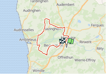
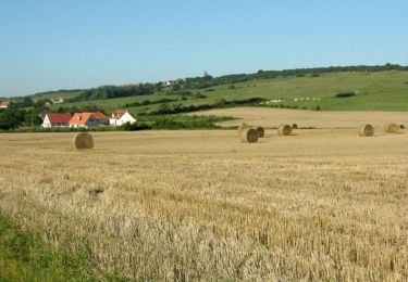
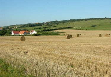
Randonnée V.T.T. de 23 km à découvrir à Hauts-de-France, Pas-de-Calais, Marquise. Cette randonnée est proposée par DidierDHane.
Description
VTT au départ du superbe gîte
"Les Yeules" au lieu dit Hardenthun à Marquise.
Très belle boucle 1/2 VTT, 1/2 petites routes de campagne peu fréquentées.
25 km
Localisation
Pays :
France
Région :
Hauts-de-France
Département/Province :
Pas-de-Calais
Commune :
Marquise
Localité :
Unknown
Départ:(Dec)
Départ:(UTM)
408103 ; 5628163 (31U) N.
Commentaires
Randonnées à proximité
![Randonnée Marche Wimille - Balade sur le sentier du Denacre - Photo](https://media.geolcdn.com/t/375/260/ext.jpg?maxdim=2&url=https%3A%2F%2Fservices.sitytrail.com%2FGeolivesWS%2FDownloadMedia.ashx%3FTrailID%3D638580%26Media%3Dbb03aebe-b688-479d-8773-5a86670387c9.jpg)
![Marche Marche](https://static1.geolcdn.com/sitytour/trail-icons/101.png)
Balade sur le sentier du Denacre
Marche
Très facile
(5)
Wimille,
Hauts-de-France,
Pas-de-Calais,
France
![](/images/other/stat-length.png)
9,8 km | 11,4 km-effort
2h 30min
![](https://static1.geolcdn.com/siteimages/upload/files/16400158638029165_repeat_loop_refresh_sync_direction_icon.png)
Oui
![Randonnée A pied Bazinghen - Sentier Les Voyettes - Photo](https://media.geolcdn.com/t/375/260/b6cdb1eb-ec5b-4936-8deb-094b1180094d.jpeg&format=jpg&maxdim=2)
![A pied A pied](https://static1.geolcdn.com/sitytour/trail-icons/100.png)
Sentier Les Voyettes
A pied
Facile
Bazinghen,
Hauts-de-France,
Pas-de-Calais,
France
![](/images/other/stat-length.png)
9 km | 11,8 km-effort
2h 41min
![](https://static1.geolcdn.com/siteimages/upload/files/16400158638029165_repeat_loop_refresh_sync_direction_icon.png)
Oui
![Randonnée Marche Wimille - Wimille - Photo](https://media.geolcdn.com/t/375/260/131a7da7-269e-42b3-bf90-a9abf57566c9.jpg&format=jpg&maxdim=2)
![Marche Marche](https://static1.geolcdn.com/sitytour/trail-icons/101.png)
Wimille
Marche
Facile
(2)
Wimille,
Hauts-de-France,
Pas-de-Calais,
France
![](/images/other/stat-length.png)
11,4 km | 13,2 km-effort
2h 48min
![](https://static1.geolcdn.com/siteimages/upload/files/16400158638029165_repeat_loop_refresh_sync_direction_icon.png)
Oui
![Randonnée A pied Maninghen-Henne - Sentier Le Rendal - Photo](https://media.geolcdn.com/t/375/260/1d61022c-2aaf-46a0-b994-eaf40efecb66.jpeg&format=jpg&maxdim=2)
![A pied A pied](https://static1.geolcdn.com/sitytour/trail-icons/100.png)
Sentier Le Rendal
A pied
Facile
Maninghen-Henne,
Hauts-de-France,
Pas-de-Calais,
France
![](/images/other/stat-length.png)
4,5 km | 5,4 km-effort
1h 13min
![](https://static1.geolcdn.com/siteimages/upload/files/16400158638029165_repeat_loop_refresh_sync_direction_icon.png)
Oui
![Randonnée Marche Bazinghen - Sentier Les Voyettes - Bazinghen - Photo](https://media.geolcdn.com/t/375/260/ext.jpg?maxdim=2&url=https%3A%2F%2Fservices.sitytrail.com%2FGeolivesWS%2FDownloadMedia.ashx%3FTrailID%3D465746%26Media%3D412415d7-216c-4957-bb52-e450972b5e98.jpg)
![Marche Marche](https://static1.geolcdn.com/sitytour/trail-icons/101.png)
Sentier Les Voyettes - Bazinghen
Marche
Moyen
Bazinghen,
Hauts-de-France,
Pas-de-Calais,
France
![](/images/other/stat-length.png)
9,4 km | 12,3 km-effort
2h 19min
![](https://static1.geolcdn.com/siteimages/upload/files/16400158638029165_repeat_loop_refresh_sync_direction_icon.png)
Oui
![Randonnée Marche Bazinghen - Sentier Les Voyettes - Bazinghen - Photo](https://media.geolcdn.com/t/375/260/ext.jpg?maxdim=2&url=https%3A%2F%2Fservices.sitytrail.com%2FGeolivesWS%2FDownloadMedia.ashx%3FTrailID%3D103203%26Media%3D5070_2.jpg)
![Marche Marche](https://static1.geolcdn.com/sitytour/trail-icons/101.png)
Sentier Les Voyettes - Bazinghen
Marche
Moyen
Bazinghen,
Hauts-de-France,
Pas-de-Calais,
France
![](/images/other/stat-length.png)
9,4 km | 12,3 km-effort
2h 19min
![](https://static1.geolcdn.com/siteimages/upload/files/16400158638029165_repeat_loop_refresh_sync_direction_icon.png)
Oui
![Randonnée Marche Bazinghen - Blériot jour 4 - Photo](https://media.geolcdn.com/t/375/260/ext.jpg?maxdim=2&url=https%3A%2F%2Fstatic1.geolcdn.com%2Fsiteimages%2Fupload%2Ffiles%2F1553511878bg_sport_marche.png)
![Marche Marche](https://static1.geolcdn.com/sitytour/trail-icons/101.png)
Blériot jour 4
Marche
Difficile
Bazinghen,
Hauts-de-France,
Pas-de-Calais,
France
![](/images/other/stat-length.png)
9,7 km | 12,5 km-effort
2h 9min
![](https://static1.geolcdn.com/siteimages/upload/files/16400158638029165_repeat_loop_refresh_sync_direction_icon.png)
Oui
![Randonnée Marche Bazinghen - Bazinghen départ Saint Eloi - Photo](https://media.geolcdn.com/t/375/260/5bcef41c-1518-4bc5-aa7f-1e2c00e0a974.jpg&format=jpg&maxdim=2)
![Marche Marche](https://static1.geolcdn.com/sitytour/trail-icons/101.png)
Bazinghen départ Saint Eloi
Marche
Très facile
Bazinghen,
Hauts-de-France,
Pas-de-Calais,
France
![](/images/other/stat-length.png)
3,3 km | 4,3 km-effort
1h 17min
![](https://static1.geolcdn.com/siteimages/upload/files/16400158638029165_repeat_loop_refresh_sync_direction_icon.png)
Oui
![Randonnée Marche Wimille - Wimille-Boulogne-Wimereux-Wimille - Photo](https://media.geolcdn.com/t/375/260/ext.jpg?maxdim=2&url=https%3A%2F%2Fstatic1.geolcdn.com%2Fsiteimages%2Fupload%2Ffiles%2F1553511878bg_sport_marche.png)
![Marche Marche](https://static1.geolcdn.com/sitytour/trail-icons/101.png)
Wimille-Boulogne-Wimereux-Wimille
Marche
Très facile
Wimille,
Hauts-de-France,
Pas-de-Calais,
France
![](/images/other/stat-length.png)
15,3 km | 18,2 km-effort
5h 30min
![](https://static1.geolcdn.com/siteimages/upload/files/16400158638029165_repeat_loop_refresh_sync_direction_icon.png)
Oui