![](/images/other/stat-length.png)
![Randonnée Marche Teguise - suuntoapp-Walking-2023-01-22 - Photo](https://media.geolcdn.com/t/1900/400/3f1152b7-4980-4320-bf05-357b9ac58827.jpg&format=pjpeg&maxdim=2)
suuntoapp-Walking-2023-01-22
MarcBoscher
Utilisateur
![Longueur](/images/other/stat-length.png)
Longueur
14,2 km
![Altitude max](https://static1.geolcdn.com/siteimages/upload/files/1508320355ic_sort_altitude_max_24dp.png)
Altitude max
627 m
![Dénivelé positif](https://static1.geolcdn.com/siteimages/upload/files/1508320355ic_sort_den_pos_24dp.png)
Dénivelé positif
669 m
![Km-Effort](/images/other/stat-length.png)
Km-Effort
23 km
![Altitude min](https://static1.geolcdn.com/siteimages/upload/files/1508320355ic_sort_altitude_min_24dp.png)
Altitude min
53 m
![Dénivelé négatif](https://static1.geolcdn.com/siteimages/upload/files/1508320355ic_sort_den_neg_24dp.png)
Dénivelé négatif
675 m
![Boucle](https://static1.geolcdn.com/siteimages/upload/files/16400158638029165_repeat_loop_refresh_sync_direction_icon.png)
Boucle
Oui
Date de création :
2023-04-06 15:17:47.502
Dernière modification :
2023-04-06 15:36:04.22
![Marche](https://static1.geolcdn.com/sitytour/trail-icons/101.png)
5h16
Difficulté : Très difficile
![Scannez ce code QR pour ouvrir la randonnée dans l'application SityTrail](https://capi.geolives.com/qq0zvz2zws4bq2lad0pu/sitytour/trails/3611439/qr.png?size=200)
Application GPS de randonnée GRATUITE
À propos
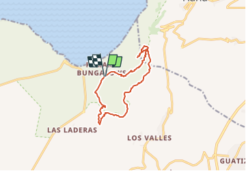
Randonnée Marche de 14,2 km à découvrir à Îles Canaries, Las Palmas, Teguise. Cette randonnée est proposée par MarcBoscher.
Description
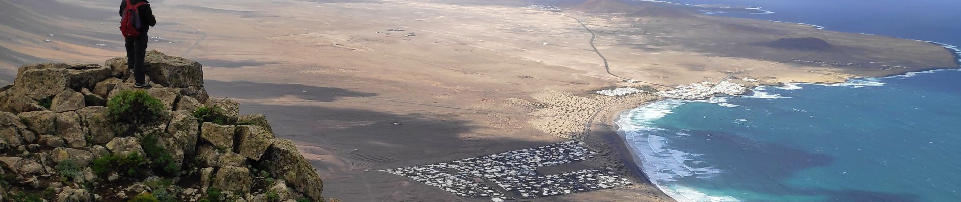
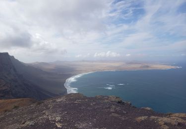
Départ de Famara Bungalow. On passe par une petite gorge et on voit en haut l'observatoire. arrivée en haut aller à la pointe sommet el Castillero 615 m super vue. On revient et on suit un chemin en bordure de falaise et on redescend sur Famara.
Localisation
Pays :
Espagne
Région :
Îles Canaries
Département/Province :
Las Palmas
Commune :
Teguise
Localité :
Unknown
Départ:(Dec)
Départ:(UTM)
641556 ; 3221138 (28R) N.
Commentaires
Randonnées à proximité
![Randonnée Marche Haría - Montaña Ganada 17.10.24 - Photo](https://media.geolcdn.com/t/375/260/a55bca47-3633-4eba-8b5c-f022a16d629e.jpg&format=jpg&maxdim=2)
![Marche Marche](https://static1.geolcdn.com/sitytour/trail-icons/101.png)
Montaña Ganada 17.10.24
Marche
Facile
Haría,
Îles Canaries,
Las Palmas,
Espagne
![](/images/other/stat-length.png)
1,2 km | 2,1 km-effort
30min
![](https://static1.geolcdn.com/siteimages/upload/files/16400158638029165_repeat_loop_refresh_sync_direction_icon.png)
Oui
![Randonnée Marche Haría - Lanzarote 02 du 18.10.2022 - Photo](https://media.geolcdn.com/t/375/260/ext.jpg?maxdim=2&url=https%3A%2F%2Fstatic1.geolcdn.com%2Fsiteimages%2Fupload%2Ffiles%2F1553511878bg_sport_marche.png)
![Marche Marche](https://static1.geolcdn.com/sitytour/trail-icons/101.png)
Lanzarote 02 du 18.10.2022
Marche
Moyen
Haría,
Îles Canaries,
Las Palmas,
Espagne
![](/images/other/stat-length.png)
12,3 km | 18,9 km-effort
6h 59min
![](https://static1.geolcdn.com/siteimages/upload/files/16400158638029165_repeat_loop_refresh_sync_direction_icon.png)
Non
![Randonnée Marche Teguise - w-spanje-lanzarote-wandeling - Photo](https://media.geolcdn.com/t/375/260/ext.jpg?maxdim=2&url=https%3A%2F%2Fstatic1.geolcdn.com%2Fsiteimages%2Fupload%2Ffiles%2F1553511878bg_sport_marche.png)
![Marche Marche](https://static1.geolcdn.com/sitytour/trail-icons/101.png)
w-spanje-lanzarote-wandeling
Marche
Très facile
Teguise,
Îles Canaries,
Las Palmas,
Espagne
![](/images/other/stat-length.png)
12,3 km | 16,7 km-effort
Inconnu
![](https://static1.geolcdn.com/siteimages/upload/files/16400158638029165_repeat_loop_refresh_sync_direction_icon.png)
Non
![Randonnée Marche nordique Teguise - 11-9-2013 Playa de Famara Lanzarote - Photo](https://media.geolcdn.com/t/375/260/ext.jpg?maxdim=2&url=https%3A%2F%2Fstatic1.geolcdn.com%2Fsiteimages%2Fupload%2Ffiles%2F1545311037marcheuse_200dpi.jpg)
![Marche nordique Marche nordique](https://static1.geolcdn.com/sitytour/trail-icons/102.png)
11-9-2013 Playa de Famara Lanzarote
Marche nordique
Facile
Teguise,
Îles Canaries,
Las Palmas,
Espagne
![](/images/other/stat-length.png)
4,2 km | 4,5 km-effort
1h 20min
![](https://static1.geolcdn.com/siteimages/upload/files/16400158638029165_repeat_loop_refresh_sync_direction_icon.png)
Oui
![Randonnée Marche Haría - Lanzarote 3 - Photo](https://media.geolcdn.com/t/375/260/ext.jpg?maxdim=2&url=https%3A%2F%2Fstatic1.geolcdn.com%2Fsiteimages%2Fupload%2Ffiles%2F1553511878bg_sport_marche.png)
![Marche Marche](https://static1.geolcdn.com/sitytour/trail-icons/101.png)
Lanzarote 3
Marche
Très difficile
Haría,
Îles Canaries,
Las Palmas,
Espagne
![](/images/other/stat-length.png)
13,4 km | 21 km-effort
6h 33min
![](https://static1.geolcdn.com/siteimages/upload/files/16400158638029165_repeat_loop_refresh_sync_direction_icon.png)
Non