![](/images/other/stat-length.png)
![Randonnée Marche Lanas - _lanas-servieres - Photo](https://media.geolcdn.com/t/1900/400/ext.pjpeg?maxdim=2&url=https%3A%2F%2Fstatic1.geolcdn.com%2Fsiteimages%2Fupload%2Ffiles%2F1553511878bg_sport_marche.png)
_lanas-servieres
Linerou
Utilisateur
![Longueur](/images/other/stat-length.png)
Longueur
6,6 km
![Altitude max](https://static1.geolcdn.com/siteimages/upload/files/1508320355ic_sort_altitude_max_24dp.png)
Altitude max
238 m
![Dénivelé positif](https://static1.geolcdn.com/siteimages/upload/files/1508320355ic_sort_den_pos_24dp.png)
Dénivelé positif
163 m
![Km-Effort](/images/other/stat-length.png)
Km-Effort
8,8 km
![Altitude min](https://static1.geolcdn.com/siteimages/upload/files/1508320355ic_sort_altitude_min_24dp.png)
Altitude min
137 m
![Dénivelé négatif](https://static1.geolcdn.com/siteimages/upload/files/1508320355ic_sort_den_neg_24dp.png)
Dénivelé négatif
163 m
![Boucle](https://static1.geolcdn.com/siteimages/upload/files/16400158638029165_repeat_loop_refresh_sync_direction_icon.png)
Boucle
Oui
Date de création :
2023-04-02 17:56:08.524
Dernière modification :
2023-12-31 10:36:39.426
![Marche](https://static1.geolcdn.com/sitytour/trail-icons/101.png)
1h59
Difficulté : Facile
![Scannez ce code QR pour ouvrir la randonnée dans l'application SityTrail](https://capi.geolives.com/qq0zvz2zws4bq2lad0pu/sitytour/trails/3606965/qr.png?size=200)
Application GPS de randonnée GRATUITE
À propos
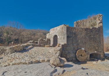
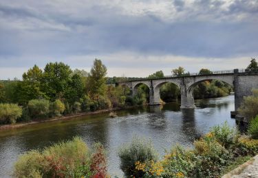
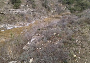
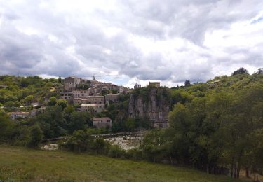
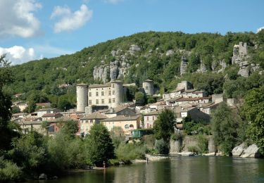
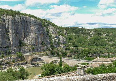
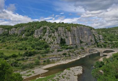
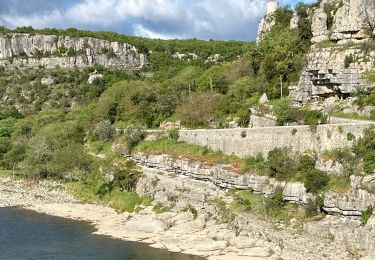
Randonnée Marche de 6,6 km à découvrir à Auvergne-Rhône-Alpes, Ardèche, Lanas. Cette randonnée est proposée par Linerou.
Description
Ballade de 2 h en pârtie au bord de l\'Ardèche. Passage sous les falaises de l\'Ardèche et découverte de la grotte de l\'Espinette.
Localisation
Pays :
France
Région :
Auvergne-Rhône-Alpes
Département/Province :
Ardèche
Commune :
Lanas
Localité :
Unknown
Départ:(Dec)
Départ:(UTM)
611221 ; 4931668 (31T) N.
Commentaires
Randonnées à proximité
![Randonnée Marche Lavilledieu - Lavilledieu Vogüé 15,5km - Photo](https://media.geolcdn.com/t/375/260/1bdbb61c-3b5b-4058-bb64-9584eec194ea.jpg&format=jpg&maxdim=2)
![Marche Marche](https://static1.geolcdn.com/sitytour/trail-icons/101.png)
Lavilledieu Vogüé 15,5km
Marche
Difficile
(2)
Lavilledieu,
Auvergne-Rhône-Alpes,
Ardèche,
France
![](/images/other/stat-length.png)
14,9 km | 18,7 km-effort
4h 15min
![](https://static1.geolcdn.com/siteimages/upload/files/16400158638029165_repeat_loop_refresh_sync_direction_icon.png)
Oui
![Randonnée Marche Vogüé - Vogue Gare Lanas 7km5 - Photo](https://media.geolcdn.com/t/375/260/9aa975b1-7a6b-4ed1-96ac-4f4c9e1e47b3.jpg&format=jpg&maxdim=2)
![Marche Marche](https://static1.geolcdn.com/sitytour/trail-icons/101.png)
Vogue Gare Lanas 7km5
Marche
Facile
(1)
Vogüé,
Auvergne-Rhône-Alpes,
Ardèche,
France
![](/images/other/stat-length.png)
7,4 km | 8,8 km-effort
2h 3min
![](https://static1.geolcdn.com/siteimages/upload/files/16400158638029165_repeat_loop_refresh_sync_direction_icon.png)
Oui
![Randonnée Marche Rochecolombe - 07 rochecompmbe gour sompe - Photo](https://media.geolcdn.com/t/375/260/7497dab0-2442-416d-a2d3-895bfda1b0d4.jpg&format=jpg&maxdim=2)
![Marche Marche](https://static1.geolcdn.com/sitytour/trail-icons/101.png)
07 rochecompmbe gour sompe
Marche
Moyen
Rochecolombe,
Auvergne-Rhône-Alpes,
Ardèche,
France
![](/images/other/stat-length.png)
17 km | 23 km-effort
6h 22min
![](https://static1.geolcdn.com/siteimages/upload/files/16400158638029165_repeat_loop_refresh_sync_direction_icon.png)
Oui
![Randonnée Marche Chauzon - camping le coin charmant Chauzon à Balazuc - Photo](https://media.geolcdn.com/t/375/260/9e3472da-95e6-4ca9-9834-4874ef8e1852.jpg&format=jpg&maxdim=2)
![Marche Marche](https://static1.geolcdn.com/sitytour/trail-icons/101.png)
camping le coin charmant Chauzon à Balazuc
Marche
Moyen
Chauzon,
Auvergne-Rhône-Alpes,
Ardèche,
France
![](/images/other/stat-length.png)
13,4 km | 19,2 km-effort
3h 8min
![](https://static1.geolcdn.com/siteimages/upload/files/16400158638029165_repeat_loop_refresh_sync_direction_icon.png)
Oui
![Randonnée Marche Saint-Germain - St-Germain Vogüé 10km. - Photo](https://media.geolcdn.com/t/375/260/7e1801e3-44f6-42d9-a0bd-32018c808368.jpg&format=jpg&maxdim=2)
![Marche Marche](https://static1.geolcdn.com/sitytour/trail-icons/101.png)
St-Germain Vogüé 10km.
Marche
Moyen
Saint-Germain,
Auvergne-Rhône-Alpes,
Ardèche,
France
![](/images/other/stat-length.png)
9,6 km | 11,9 km-effort
2h 40min
![](https://static1.geolcdn.com/siteimages/upload/files/16400158638029165_repeat_loop_refresh_sync_direction_icon.png)
Oui
![Randonnée Marche Balazuc - Balazuc Cirque de Gens 19km. - Photo](https://media.geolcdn.com/t/375/260/6d01c6fd-5949-41a2-b340-daa374c534bc.jpg&format=jpg&maxdim=2)
![Marche Marche](https://static1.geolcdn.com/sitytour/trail-icons/101.png)
Balazuc Cirque de Gens 19km.
Marche
Très difficile
Balazuc,
Auvergne-Rhône-Alpes,
Ardèche,
France
![](/images/other/stat-length.png)
19,2 km | 26 km-effort
5h 53min
![](https://static1.geolcdn.com/siteimages/upload/files/16400158638029165_repeat_loop_refresh_sync_direction_icon.png)
Oui
![Randonnée Marche Balazuc - Balazuc Servieres Viel-Audon 9km. - Photo](https://media.geolcdn.com/t/375/260/c62c36d0-f3c1-47de-a635-486a1871b8d7.jpg&format=jpg&maxdim=2)
![Marche Marche](https://static1.geolcdn.com/sitytour/trail-icons/101.png)
Balazuc Servieres Viel-Audon 9km.
Marche
Difficile
Balazuc,
Auvergne-Rhône-Alpes,
Ardèche,
France
![](/images/other/stat-length.png)
9 km | 12,7 km-effort
2h 53min
![](https://static1.geolcdn.com/siteimages/upload/files/16400158638029165_repeat_loop_refresh_sync_direction_icon.png)
Oui
![Randonnée sport Saint-Sernin - 2024-05-10_14h11m42_serre de vinobre - v3 (2) - Photo](https://media.geolcdn.com/t/375/260/ext.jpg?maxdim=2&url=https%3A%2F%2Fsecurestorage.geolives.com%2Fsitytour%2Ftrail-bg%2Fdefault.jpg)
2024-05-10_14h11m42_serre de vinobre - v3 (2)
sport
Très facile
(1)
Saint-Sernin,
Auvergne-Rhône-Alpes,
Ardèche,
France
![](/images/other/stat-length.png)
6,5 km | 9,1 km-effort
Inconnu
![](https://static1.geolcdn.com/siteimages/upload/files/16400158638029165_repeat_loop_refresh_sync_direction_icon.png)
Oui
![Randonnée sport Balazuc - Balazuc la tour de Jeanne le Viel Audon - Photo](https://media.geolcdn.com/t/375/260/d8c1c8fe-95e6-4adc-b1ae-0d66c200e42e.jpg&format=jpg&maxdim=2)
Balazuc la tour de Jeanne le Viel Audon
sport
Très facile
Balazuc,
Auvergne-Rhône-Alpes,
Ardèche,
France
![](/images/other/stat-length.png)
8,5 km | 12,3 km-effort
Inconnu
![](https://static1.geolcdn.com/siteimages/upload/files/16400158638029165_repeat_loop_refresh_sync_direction_icon.png)
Oui