![](/images/other/stat-length.png)
![Randonnée Marche La Guérinière - En passant par les moulins - Photo](https://media.geolcdn.com/t/1900/400/ext.pjpeg?maxdim=2&url=https%3A%2F%2Fstatic1.geolcdn.com%2Fsiteimages%2Fupload%2Ffiles%2F1553511878bg_sport_marche.png)
En passant par les moulins
BureauChris
Utilisateur
![Longueur](/images/other/stat-length.png)
Longueur
15,1 km
![Altitude max](https://static1.geolcdn.com/siteimages/upload/files/1508320355ic_sort_altitude_max_24dp.png)
Altitude max
22 m
![Dénivelé positif](https://static1.geolcdn.com/siteimages/upload/files/1508320355ic_sort_den_pos_24dp.png)
Dénivelé positif
71 m
![Km-Effort](/images/other/stat-length.png)
Km-Effort
16 km
![Altitude min](https://static1.geolcdn.com/siteimages/upload/files/1508320355ic_sort_altitude_min_24dp.png)
Altitude min
-3 m
![Dénivelé négatif](https://static1.geolcdn.com/siteimages/upload/files/1508320355ic_sort_den_neg_24dp.png)
Dénivelé négatif
68 m
![Boucle](https://static1.geolcdn.com/siteimages/upload/files/16400158638029165_repeat_loop_refresh_sync_direction_icon.png)
Boucle
Oui
Date de création :
2023-04-01 17:04:39.0
Dernière modification :
2023-04-01 17:05:09.496
![Marche](https://static1.geolcdn.com/sitytour/trail-icons/101.png)
3h38
Difficulté : Difficile
![Scannez ce code QR pour ouvrir la randonnée dans l'application SityTrail](https://capi.geolives.com/qq0zvz2zws4bq2lad0pu/sitytour/trails/3605580/qr.png?size=200)
Application GPS de randonnée GRATUITE
À propos
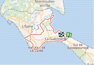
Randonnée Marche de 15,1 km à découvrir à Pays de la Loire, Vendée, La Guérinière. Cette randonnée est proposée par BureauChris.
Description
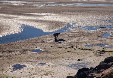
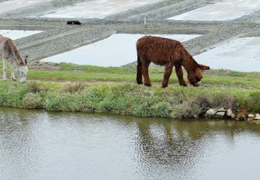
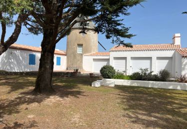
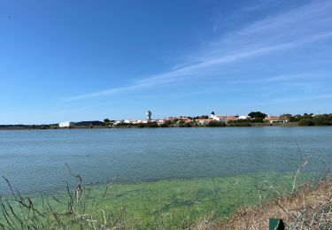
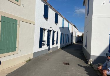
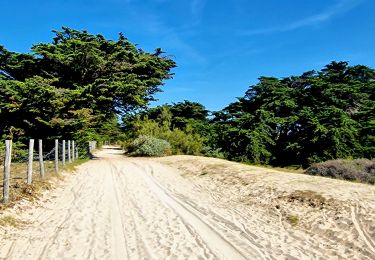
Ce circuit pédestre, de 15,1 km, offre une promenade au cœur de l'île de Noirmoutier à travers des paysages très variés : dunes, marais, forêts. Suivez le balisage jaune pour découvrir toutes les richesses naturelles qu'il vous réserve.
Localisation
Pays :
France
Région :
Pays de la Loire
Département/Province :
Vendée
Commune :
La Guérinière
Localité :
Unknown
Départ:(Dec)
Départ:(UTM)
559540 ; 5201750 (30T) N.
Commentaires
Randonnées à proximité
![Randonnée A pied Noirmoutier-en-l'Île - Sur les traces des Jacobsen - Photo](https://media.geolcdn.com/t/375/260/ext.jpg?maxdim=2&url=https%3A%2F%2Fmedia.geolcdn.com%2Ff%2F6222f97e-2beb-47c2-ac73-1db88481adbd.jpeg)
![A pied A pied](https://static1.geolcdn.com/sitytour/trail-icons/100.png)
Sur les traces des Jacobsen
A pied
Facile
Noirmoutier-en-l'Île,
Pays de la Loire,
Vendée,
France
![](/images/other/stat-length.png)
8,4 km | 9,2 km-effort
2h 5min
![](https://static1.geolcdn.com/siteimages/upload/files/16400158638029165_repeat_loop_refresh_sync_direction_icon.png)
Oui
![Randonnée A pied Noirmoutier-en-l'Île - Roses trémières - Photo](https://media.geolcdn.com/t/375/260/ext.jpg?maxdim=2&url=https%3A%2F%2Fmedia.geolcdn.com%2Ff%2F504a4f09-026b-4f3b-a144-9641852cfb05.jpeg)
![A pied A pied](https://static1.geolcdn.com/sitytour/trail-icons/100.png)
Roses trémières
A pied
Facile
Noirmoutier-en-l'Île,
Pays de la Loire,
Vendée,
France
![](/images/other/stat-length.png)
5,5 km | 5,7 km-effort
1h 18min
![](https://static1.geolcdn.com/siteimages/upload/files/16400158638029165_repeat_loop_refresh_sync_direction_icon.png)
Oui
![Randonnée A pied La Guérinière - En Passant par les Moulins - Photo](https://media.geolcdn.com/t/375/260/ext.jpg?maxdim=2&url=https%3A%2F%2Fmedia.geolcdn.com%2Ff%2Fccc103f2-0cff-4e2a-b30b-b4e364a262b4.jpeg)
![A pied A pied](https://static1.geolcdn.com/sitytour/trail-icons/100.png)
En Passant par les Moulins
A pied
Facile
La Guérinière,
Pays de la Loire,
Vendée,
France
![](/images/other/stat-length.png)
12,1 km | 13 km-effort
2h 56min
![](https://static1.geolcdn.com/siteimages/upload/files/16400158638029165_repeat_loop_refresh_sync_direction_icon.png)
Non
![Randonnée Marche L'Épine - Noirmoutier 3 - Photo](https://media.geolcdn.com/t/375/260/ext.jpg?maxdim=2&url=https%3A%2F%2Fmedia.geolcdn.com%2Ff%2F640ca307-094e-454b-910c-add2497a7004.jpg)
![Marche Marche](https://static1.geolcdn.com/sitytour/trail-icons/101.png)
Noirmoutier 3
Marche
L'Épine,
Pays de la Loire,
Vendée,
France
![](/images/other/stat-length.png)
15,1 km | 16,2 km-effort
2h 24min
![](https://static1.geolcdn.com/siteimages/upload/files/16400158638029165_repeat_loop_refresh_sync_direction_icon.png)
Non
![Randonnée Marche Noirmoutier-en-l'Île - Randonnée nord Noirmoutier - Photo](https://media.geolcdn.com/t/375/260/ext.jpg?maxdim=2&url=https%3A%2F%2Fmedia.geolcdn.com%2Ff%2F546cf5a8-bd2d-412f-a2bb-12023648116c.jpg)
![Marche Marche](https://static1.geolcdn.com/sitytour/trail-icons/101.png)
Randonnée nord Noirmoutier
Marche
Très facile
Noirmoutier-en-l'Île,
Pays de la Loire,
Vendée,
France
![](/images/other/stat-length.png)
17,9 km | 19 km-effort
4h 22min
![](https://static1.geolcdn.com/siteimages/upload/files/16400158638029165_repeat_loop_refresh_sync_direction_icon.png)
Non
![Randonnée Marche Noirmoutier-en-l'Île - Noirmoutier, premier jour, mise en jambe - Photo](https://media.geolcdn.com/t/375/260/ext.jpg?maxdim=2&url=https%3A%2F%2Fmedia.geolcdn.com%2Ff%2F44557226-b7a7-4ccf-bccc-db2a3325466d.jpg)
![Marche Marche](https://static1.geolcdn.com/sitytour/trail-icons/101.png)
Noirmoutier, premier jour, mise en jambe
Marche
Noirmoutier-en-l'Île,
Pays de la Loire,
Vendée,
France
![](/images/other/stat-length.png)
9,2 km | 10,1 km-effort
2h 29min
![](https://static1.geolcdn.com/siteimages/upload/files/16400158638029165_repeat_loop_refresh_sync_direction_icon.png)
Oui
![Randonnée Marche Barbâtre - Jeun et Rando J5 - Passage du gois et réserve naturelle - Photo](https://media.geolcdn.com/t/375/260/ext.jpg?maxdim=2&url=https%3A%2F%2Fmedia.geolcdn.com%2Ff%2F63982714-02ad-4988-81a1-3136e11c938c.jpg)
![Marche Marche](https://static1.geolcdn.com/sitytour/trail-icons/101.png)
Jeun et Rando J5 - Passage du gois et réserve naturelle
Marche
Très facile
Barbâtre,
Pays de la Loire,
Vendée,
France
![](/images/other/stat-length.png)
10,1 km | 10,5 km-effort
2h 4min
![](https://static1.geolcdn.com/siteimages/upload/files/16400158638029165_repeat_loop_refresh_sync_direction_icon.png)
Oui
![Randonnée Marche Noirmoutier-en-l'Île - Noirmoutier_LeGrandVieil_2022_R2 - Photo](https://media.geolcdn.com/t/375/260/ext.jpg?maxdim=2&url=https%3A%2F%2Fstatic1.geolcdn.com%2Fsiteimages%2Fupload%2Ffiles%2F1553511878bg_sport_marche.png)
![Marche Marche](https://static1.geolcdn.com/sitytour/trail-icons/101.png)
Noirmoutier_LeGrandVieil_2022_R2
Marche
Difficile
(2)
Noirmoutier-en-l'Île,
Pays de la Loire,
Vendée,
France
![](/images/other/stat-length.png)
16 km | 17,4 km-effort
3h 56min
![](https://static1.geolcdn.com/siteimages/upload/files/16400158638029165_repeat_loop_refresh_sync_direction_icon.png)
Oui
![Randonnée Marche Noirmoutier-en-l'Île - Noirmoutier_LeGrandVieil_2022_R - Photo](https://media.geolcdn.com/t/375/260/ext.jpg?maxdim=2&url=https%3A%2F%2Fstatic1.geolcdn.com%2Fsiteimages%2Fupload%2Ffiles%2F1553511878bg_sport_marche.png)
![Marche Marche](https://static1.geolcdn.com/sitytour/trail-icons/101.png)
Noirmoutier_LeGrandVieil_2022_R
Marche
Difficile
(2)
Noirmoutier-en-l'Île,
Pays de la Loire,
Vendée,
France
![](/images/other/stat-length.png)
16,7 km | 18,2 km-effort
4h 8min
![](https://static1.geolcdn.com/siteimages/upload/files/16400158638029165_repeat_loop_refresh_sync_direction_icon.png)
Oui