![](/images/other/stat-length.png)
![Randonnée Marche Stoumont - Marche ADEPS du 23/07/2023 Parcours des 5km - Photo](https://media.geolcdn.com/t/1900/400/ext.pjpeg?maxdim=2&url=https%3A%2F%2Fstatic1.geolcdn.com%2Fsiteimages%2Fupload%2Ffiles%2F1553511878bg_sport_marche.png)
Marche ADEPS du 23/07/2023 Parcours des 5km
danyhermans1607@gmail.com
Utilisateur
![Longueur](/images/other/stat-length.png)
Longueur
4,7 km
![Altitude max](https://static1.geolcdn.com/siteimages/upload/files/1508320355ic_sort_altitude_max_24dp.png)
Altitude max
357 m
![Dénivelé positif](https://static1.geolcdn.com/siteimages/upload/files/1508320355ic_sort_den_pos_24dp.png)
Dénivelé positif
166 m
![Km-Effort](/images/other/stat-length.png)
Km-Effort
7 km
![Altitude min](https://static1.geolcdn.com/siteimages/upload/files/1508320355ic_sort_altitude_min_24dp.png)
Altitude min
207 m
![Dénivelé négatif](https://static1.geolcdn.com/siteimages/upload/files/1508320355ic_sort_den_neg_24dp.png)
Dénivelé négatif
164 m
![Boucle](https://static1.geolcdn.com/siteimages/upload/files/16400158638029165_repeat_loop_refresh_sync_direction_icon.png)
Boucle
Oui
Date de création :
2023-03-30 08:17:03.553
Dernière modification :
2023-03-30 08:30:22.207
![Marche](https://static1.geolcdn.com/sitytour/trail-icons/101.png)
1h34
Difficulté : Moyen
![Scannez ce code QR pour ouvrir la randonnée dans l'application SityTrail](https://capi.geolives.com/qq0zvz2zws4bq2lad0pu/sitytour/trails/3602598/qr.png?size=200)
Application GPS de randonnée GRATUITE
À propos
Randonnée Marche de 4,7 km à découvrir à Wallonie, Liège, Stoumont. Cette randonnée est proposée par danyhermans1607@gmail.com .
Description
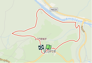
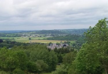
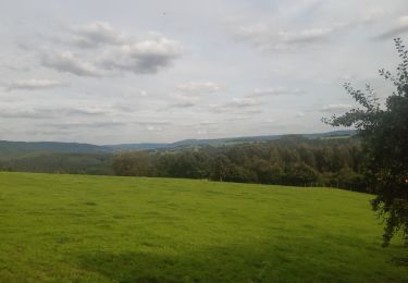
C'est un parcours qui passe par le village de Lorcé puis longe la rive gauche de l'Amblève en corniche, passe par le barrage de Lorcé et remonte sur le village.
Localisation
Pays :
Belgique
Région :
Wallonie
Département/Province :
Liège
Commune :
Stoumont
Localité :
Unknown
Départ:(Dec)
Départ:(UTM)
694240 ; 5588423 (31U) N.
Commentaires
Randonnées à proximité
![Randonnée Marche Stoumont - Lorcé, Natura 2000 - Des sites qui valent le détour, Lg13 - Photo](https://media.geolcdn.com/t/375/260/ext.jpg?maxdim=2&url=https%3A%2F%2Fservices.sitytrail.com%2FGeolivesWS%2FDownloadMedia.ashx%3FTrailID%3D182859%26Media%3D43b80b1e-327b-4d3e-accc-f8b9c8a445c2.JPG)
![Marche Marche](https://static1.geolcdn.com/sitytour/trail-icons/101.png)
Lorcé, Natura 2000 - Des sites qui valent le détour, Lg13
Marche
Facile
(7)
Stoumont,
Wallonie,
Liège,
Belgique
![](/images/other/stat-length.png)
6,1 km | 8,9 km-effort
1h 57min
![](https://static1.geolcdn.com/siteimages/upload/files/16400158638029165_repeat_loop_refresh_sync_direction_icon.png)
Oui
![Randonnée Marche Stoumont - RB-Lg-14_Chevron_via-racc - Photo](https://media.geolcdn.com/t/375/260/ext.jpg?maxdim=2&url=https%3A%2F%2Fservices.sitytrail.com%2FGeolivesWS%2FDownloadMedia.ashx%3FTrailID%3D179572%26Media%3Ddd649bf1-a115-4c1e-9e23-c1a80ab51103.jpg)
![Marche Marche](https://static1.geolcdn.com/sitytour/trail-icons/101.png)
RB-Lg-14_Chevron_via-racc
Marche
Très difficile
(5)
Stoumont,
Wallonie,
Liège,
Belgique
![](/images/other/stat-length.png)
17 km | 24 km-effort
5h 28min
![](https://static1.geolcdn.com/siteimages/upload/files/16400158638029165_repeat_loop_refresh_sync_direction_icon.png)
Oui
![Randonnée Marche Aywaille - RB-Lg-15_Harzé - Photo](https://media.geolcdn.com/t/375/260/ext.jpg?maxdim=2&url=https%3A%2F%2Fservices.sitytrail.com%2FGeolivesWS%2FDownloadMedia.ashx%3FTrailID%3D179573%26Media%3D790acd11-a9eb-4644-bdd3-c1540608bba1.jpg)
![Marche Marche](https://static1.geolcdn.com/sitytour/trail-icons/101.png)
RB-Lg-15_Harzé
Marche
Difficile
(7)
Aywaille,
Wallonie,
Liège,
Belgique
![](/images/other/stat-length.png)
22 km | 30 km-effort
6h 10min
![](https://static1.geolcdn.com/siteimages/upload/files/16400158638029165_repeat_loop_refresh_sync_direction_icon.png)
Oui
![Randonnée Marche Stoumont - Stoumont - P14 Promenade des sommets de la Lienne - Photo](https://media.geolcdn.com/t/375/260/a2987c7f-4dfa-4904-87e7-be0c835ea8dd.jpg&format=jpg&maxdim=2)
![Marche Marche](https://static1.geolcdn.com/sitytour/trail-icons/101.png)
Stoumont - P14 Promenade des sommets de la Lienne
Marche
Moyen
(2)
Stoumont,
Wallonie,
Liège,
Belgique
![](/images/other/stat-length.png)
16,1 km | 23 km-effort
5h 11min
![](https://static1.geolcdn.com/siteimages/upload/files/16400158638029165_repeat_loop_refresh_sync_direction_icon.png)
Oui
![Randonnée Marche Stoumont - lorcé . suf la lienne . Chevron . lorcé - Photo](https://media.geolcdn.com/t/375/260/9599f201-d2ad-4521-ad0a-b4661e5a5ff4.jpg&format=jpg&maxdim=2)
![Marche Marche](https://static1.geolcdn.com/sitytour/trail-icons/101.png)
lorcé . suf la lienne . Chevron . lorcé
Marche
Très facile
(1)
Stoumont,
Wallonie,
Liège,
Belgique
![](/images/other/stat-length.png)
15,9 km | 22 km-effort
5h 41min
![](https://static1.geolcdn.com/siteimages/upload/files/16400158638029165_repeat_loop_refresh_sync_direction_icon.png)
Oui
![Randonnée Marche Aywaille - houssonloge . bois du pouhon . trou de bosson . paradis . houssonloge - Photo](https://media.geolcdn.com/t/375/260/8bc033a3-d4f5-4c9f-9bb4-a2d3fb614b59.jpg&format=jpg&maxdim=2)
![Marche Marche](https://static1.geolcdn.com/sitytour/trail-icons/101.png)
houssonloge . bois du pouhon . trou de bosson . paradis . houssonloge
Marche
Très facile
(4)
Aywaille,
Wallonie,
Liège,
Belgique
![](/images/other/stat-length.png)
9,1 km | 12,4 km-effort
2h 49min
![](https://static1.geolcdn.com/siteimages/upload/files/16400158638029165_repeat_loop_refresh_sync_direction_icon.png)
Oui
![Randonnée Marche Stoumont - RB-Lg-14_Chevron - Photo](https://media.geolcdn.com/t/375/260/ext.jpg?maxdim=2&url=https%3A%2F%2Fservices.sitytrail.com%2FGeolivesWS%2FDownloadMedia.ashx%3FTrailID%3D179572%26Media%3Ddd649bf1-a115-4c1e-9e23-c1a80ab51103.jpg)
![Marche Marche](https://static1.geolcdn.com/sitytour/trail-icons/101.png)
RB-Lg-14_Chevron
Marche
Très difficile
(4)
Stoumont,
Wallonie,
Liège,
Belgique
![](/images/other/stat-length.png)
22 km | 30 km-effort
6h 53min
![](https://static1.geolcdn.com/siteimages/upload/files/16400158638029165_repeat_loop_refresh_sync_direction_icon.png)
Oui
![Randonnée Marche Stoumont - 10km sous la pluie autour de Lorcé - Photo](https://media.geolcdn.com/t/375/260/cbc0016a-dfca-4c73-9974-c42c5bf54007.jpg&format=jpg&maxdim=2)
![Marche Marche](https://static1.geolcdn.com/sitytour/trail-icons/101.png)
10km sous la pluie autour de Lorcé
Marche
Facile
(1)
Stoumont,
Wallonie,
Liège,
Belgique
![](/images/other/stat-length.png)
10,6 km | 14,1 km-effort
2h 47min
![](https://static1.geolcdn.com/siteimages/upload/files/16400158638029165_repeat_loop_refresh_sync_direction_icon.png)
Oui
![Randonnée Marche Stoumont - ST12 Lorcé . Chession . Lorcé - Photo](https://media.geolcdn.com/t/375/260/4fb5fd46-a2f8-4332-bf19-91c606197682.jpg&format=jpg&maxdim=2)
![Marche Marche](https://static1.geolcdn.com/sitytour/trail-icons/101.png)
ST12 Lorcé . Chession . Lorcé
Marche
Facile
(2)
Stoumont,
Wallonie,
Liège,
Belgique
![](/images/other/stat-length.png)
12,7 km | 17,7 km-effort
4h 28min
![](https://static1.geolcdn.com/siteimages/upload/files/16400158638029165_repeat_loop_refresh_sync_direction_icon.png)
Non