![](/images/other/stat-length.png)
![Randonnée Marche Arcenant - Sentiers patrimoine et Marianne : Arcennant - Photo](https://media.geolcdn.com/t/1900/400/6752da8e-ad96-4dd4-9b3a-2267488f42f7.jpg&format=pjpeg&maxdim=2)
Sentiers patrimoine et Marianne : Arcennant
dudu42
Utilisateur GUIDE
![Longueur](/images/other/stat-length.png)
Longueur
9,8 km
![Altitude max](https://static1.geolcdn.com/siteimages/upload/files/1508320355ic_sort_altitude_max_24dp.png)
Altitude max
564 m
![Dénivelé positif](https://static1.geolcdn.com/siteimages/upload/files/1508320355ic_sort_den_pos_24dp.png)
Dénivelé positif
277 m
![Km-Effort](/images/other/stat-length.png)
Km-Effort
13,5 km
![Altitude min](https://static1.geolcdn.com/siteimages/upload/files/1508320355ic_sort_altitude_min_24dp.png)
Altitude min
330 m
![Dénivelé négatif](https://static1.geolcdn.com/siteimages/upload/files/1508320355ic_sort_den_neg_24dp.png)
Dénivelé négatif
277 m
![Boucle](https://static1.geolcdn.com/siteimages/upload/files/16400158638029165_repeat_loop_refresh_sync_direction_icon.png)
Boucle
Oui
Date de création :
2023-03-29 07:47:31.979
Dernière modification :
2023-03-29 10:50:26.339
![Marche](https://static1.geolcdn.com/sitytour/trail-icons/101.png)
2h40
Difficulté : Moyen
![Scannez ce code QR pour ouvrir la randonnée dans l'application SityTrail](https://capi.geolives.com/qq0zvz2zws4bq2lad0pu/sitytour/trails/3601672/qr.png?size=200)
Application GPS de randonnée GRATUITE
À propos
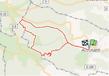
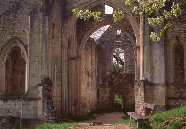
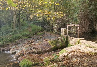
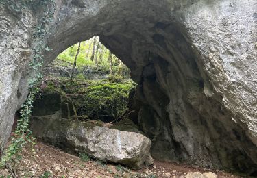
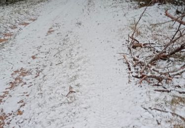
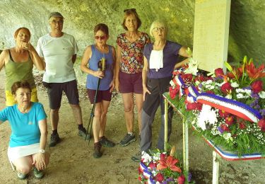
Randonnée Marche de 9,8 km à découvrir à Bourgogne-Franche-Comté, Côte-d'Or, Arcenant. Cette randonnée est proposée par dudu42.
Description
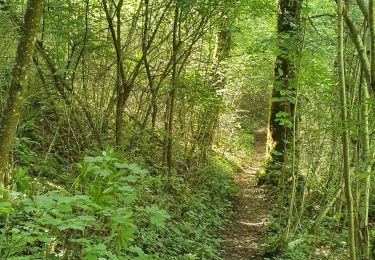
très belle randonnée avec peu de monde. Attention après fin mars , 50 m de chemin a disparu sous les ronces et arbustes. Donc privilégiez le sentier balisé !
Localisation
Pays :
France
Région :
Bourgogne-Franche-Comté
Département/Province :
Côte-d'Or
Commune :
Arcenant
Localité :
Unknown
Départ:(Dec)
Départ:(UTM)
639807 ; 5222269 (31T) N.
Commentaires
Randonnées à proximité
![Randonnée Marche Curtil-Vergy - Abbaye saint Vivant - Photo](https://media.geolcdn.com/t/375/260/040e75f6-3ed9-4472-88f3-28e2fffd2eca.jpg&format=jpg&maxdim=2)
![Marche Marche](https://static1.geolcdn.com/sitytour/trail-icons/101.png)
Abbaye saint Vivant
Marche
Curtil-Vergy,
Bourgogne-Franche-Comté,
Côte-d'Or,
France
![](/images/other/stat-length.png)
10 km | 14,3 km-effort
2h 43min
![](https://static1.geolcdn.com/siteimages/upload/files/16400158638029165_repeat_loop_refresh_sync_direction_icon.png)
Non
![Randonnée Marche Arcenant - A - Photo](https://media.geolcdn.com/t/375/260/e4ccacaa-0c16-4438-a54e-6dd5633e948a.jpg&format=jpg&maxdim=2)
![Marche Marche](https://static1.geolcdn.com/sitytour/trail-icons/101.png)
A
Marche
Très difficile
Arcenant,
Bourgogne-Franche-Comté,
Côte-d'Or,
France
![](/images/other/stat-length.png)
15 km | 20 km-effort
4h 11min
![](https://static1.geolcdn.com/siteimages/upload/files/16400158638029165_repeat_loop_refresh_sync_direction_icon.png)
Oui
![Randonnée A pied Bouilland - Tour de la Vallée du Rhoin - Photo](https://media.geolcdn.com/t/375/260/d493832b-3cd4-4631-ad38-006cf8bf3108.jpeg&format=jpg&maxdim=2)
![A pied A pied](https://static1.geolcdn.com/sitytour/trail-icons/100.png)
Tour de la Vallée du Rhoin
A pied
Facile
Bouilland,
Bourgogne-Franche-Comté,
Côte-d'Or,
France
![](/images/other/stat-length.png)
9,9 km | 15,1 km-effort
3h 25min
![](https://static1.geolcdn.com/siteimages/upload/files/16400158638029165_repeat_loop_refresh_sync_direction_icon.png)
Oui
![Randonnée Marche Arcenant - Arcenant - Sentier Marianne - Roches du Châtelet - Photo](https://media.geolcdn.com/t/375/260/01be1986-1ff9-45a8-8bb4-e4144fe03047.jpg&format=jpg&maxdim=2)
![Marche Marche](https://static1.geolcdn.com/sitytour/trail-icons/101.png)
Arcenant - Sentier Marianne - Roches du Châtelet
Marche
Difficile
Arcenant,
Bourgogne-Franche-Comté,
Côte-d'Or,
France
![](/images/other/stat-length.png)
24 km | 34 km-effort
5h 51min
![](https://static1.geolcdn.com/siteimages/upload/files/16400158638029165_repeat_loop_refresh_sync_direction_icon.png)
Oui
![Randonnée Marche Meuilley - meuilley - Photo](https://media.geolcdn.com/t/375/260/ext.jpg?maxdim=2&url=https%3A%2F%2Fstatic1.geolcdn.com%2Fsiteimages%2Fupload%2Ffiles%2F1553511878bg_sport_marche.png)
![Marche Marche](https://static1.geolcdn.com/sitytour/trail-icons/101.png)
meuilley
Marche
Très facile
(2)
Meuilley,
Bourgogne-Franche-Comté,
Côte-d'Or,
France
![](/images/other/stat-length.png)
13,3 km | 16,8 km-effort
3h 17min
![](https://static1.geolcdn.com/siteimages/upload/files/16400158638029165_repeat_loop_refresh_sync_direction_icon.png)
Oui
![Randonnée sport Bouilland - Bouilland site escalade - Photo](https://media.geolcdn.com/t/375/260/4c934685-1996-42fd-8ed0-a06b8add0cfb.jpg&format=jpg&maxdim=2)
Bouilland site escalade
sport
Très facile
Bouilland,
Bourgogne-Franche-Comté,
Côte-d'Or,
France
![](/images/other/stat-length.png)
10,5 km | 16,6 km-effort
Inconnu
![](https://static1.geolcdn.com/siteimages/upload/files/16400158638029165_repeat_loop_refresh_sync_direction_icon.png)
Oui
![Randonnée Marche Marey-lès-Fussey - Marey - Photo](https://media.geolcdn.com/t/375/260/f5c3d4eb-85a1-4cfa-8def-8457350b3366.jpg&format=jpg&maxdim=2)
![Marche Marche](https://static1.geolcdn.com/sitytour/trail-icons/101.png)
Marey
Marche
Moyen
Marey-lès-Fussey,
Bourgogne-Franche-Comté,
Côte-d'Or,
France
![](/images/other/stat-length.png)
9,3 km | 11,7 km-effort
2h 36min
![](https://static1.geolcdn.com/siteimages/upload/files/16400158638029165_repeat_loop_refresh_sync_direction_icon.png)
Oui
![Randonnée Marche Arcenant - Arcenant 19/06 - Photo](https://media.geolcdn.com/t/375/260/d9ed6864-d418-4320-bd9f-bd951789b73f.jpg&format=jpg&maxdim=2)
![Marche Marche](https://static1.geolcdn.com/sitytour/trail-icons/101.png)
Arcenant 19/06
Marche
Facile
Arcenant,
Bourgogne-Franche-Comté,
Côte-d'Or,
France
![](/images/other/stat-length.png)
10,2 km | 13,9 km-effort
3h 15min
![](https://static1.geolcdn.com/siteimages/upload/files/16400158638029165_repeat_loop_refresh_sync_direction_icon.png)
Oui
![Randonnée Marche Bouilland - RA Bouilland - Photo](https://media.geolcdn.com/t/375/260/e9740f16-e2ce-4123-9121-8ce916c4ce6e.jpg&format=jpg&maxdim=2)
![Marche Marche](https://static1.geolcdn.com/sitytour/trail-icons/101.png)
RA Bouilland
Marche
Difficile
Bouilland,
Bourgogne-Franche-Comté,
Côte-d'Or,
France
![](/images/other/stat-length.png)
8,3 km | 12,2 km-effort
3h 17min
![](https://static1.geolcdn.com/siteimages/upload/files/16400158638029165_repeat_loop_refresh_sync_direction_icon.png)
Oui