Randonnée A pied Vallorbe - The Gorge of Orbe - Photo
 famiski
famiski

Utilisateur

© OpenStreetMap contributors
Longueur
Longueur
16 km
Altitude max
Altitude max
783 m
Dénivelé positif
Dénivelé positif
251 m
Km-Effort
Km-Effort  
20 km
Altitude min
Altitude min
449 m
Dénivelé négatif
Dénivelé négatif
552 m
Boucle
Boucle
Non
Date de création :
2023-03-25 06:28:57.175
Dernière modification :
2023-03-25 06:29:19.446

(0 Avis)

A pied
A pied
4h36
Difficulté : Moyen

Scannez ce code QR pour ouvrir la randonnée dans l'application SityTrail

Application GPS de randonnée GRATUITE

Logo SityTrail SityTrail

IGN / Instituts géographiques

Télécharger SityTrail sur l'App Store Télécharger SityTrail sur Google Play

Logo SityTrail SityTrail World

Le monde est à vous

Télécharger SityTrail sur l'App Store Télécharger SityTrail sur Google Play Télécharger SityTrail sur Huawei AppGallery

À propos

Randonnée A pied de 16 km à découvrir à Vaud, District du Jura-Nord vaudois, Vallorbe. Cette randonnée est proposée par famiski.

Description

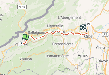
This route of 17 km between Vallorbe and Orbe invites the hiker to walk into the heart of nature. The trail intersects with the Vallorbe Viaduct and leads down to the source of the River Day, it skirts the dams of the hydroelectric plants, passes through the village of Les Clées, and finally arrives in the town of Orbe after a walk of around 4 hours and 20 minutes.

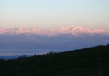
Thanks to the natural reserve that has protected the site and its flora since 1970 and has guaranteed calm for the wildlife, this excursion allows the hiker to walk through a preserved natural environment.

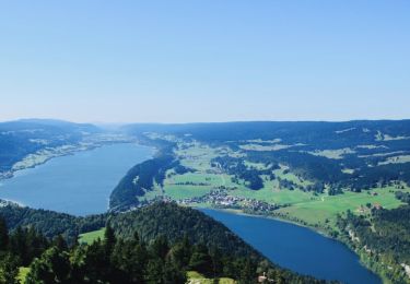
Natural pine forests, oregano, wild thyme, juniper and certain orchids can be admired along the path, as well as glacial mills in the upper part of the village of Les Clées. The River Orbe is the habitat for trout, kingfishers, grey herons, chamois and even beavers on the lower part of the trail.

Parking possibilities in Vallorbe or Orbe, busses or trains between the two localities. Restricted schedules at weekends, but the possibility of using PubliCar service. Hikers are requested to follow the path and to respect the diversions. Great care is required on all paths.

Profil altimétrique

Points d'intérêt

Point d'intérêt Vallorbe - The Gorge of Orbe - Photo
famiski

Localisation

Pays :
Suisse
Région :
Vaud
Département/Province :
District du Jura-Nord vaudois
Commune :
Vallorbe
Localité :
Unknown
Départ:(Dec)
Départ:(UTM)
299776 ; 5176510 (32T) N.

Randonnées à proximité

Randonnée V.T.T. Vallorbe - Le Suchet - Photo
V.T.T.
GUIDE+

V.T.T.

Très facile
(1)
Vallorbe, Vaud, District du Jura-Nord vaudois, Suisse
35 km | 53 km-effort
14h 41min
Oui
Randonnée A pied Vallorbe - Mont d'Orzeires - Le Pont Gare - Photo
A pied
PRO

A pied

Facile
Vallorbe, Vaud, District du Jura-Nord vaudois, Suisse
3,2 km | 4,4 km-effort
59min
Non
Randonnée A pied Ballaigues - Ballaigues-Vallorbe - Photo
A pied
PRO

A pied

Facile
Ballaigues, Vaud, District du Jura-Nord vaudois, Suisse
5,1 km | 6,3 km-effort
1h 25min
Non
Randonnée A pied Vallorbe - Saigne Geret-Les Revines - Photo
A pied
PRO

A pied

Facile
Vallorbe, Vaud, District du Jura-Nord vaudois, Suisse
3,5 km | 4,1 km-effort
56min
Non
Randonnée A pied Juriens - TP Mollendruz - Romainmôtie - Photo
A pied
PRO

A pied

Facile
Juriens, Vaud, District du Jura-Nord vaudois, Suisse
7,8 km | 11,6 km-effort
2h 38min
Non
Randonnée Marche L'Abbaye - La Dent de Vaulion - Photo
Marche
drarep

Marche

Très difficile
(1)
L'Abbaye, Vaud, District du Jura-Nord vaudois, Suisse
14,6 km | 22 km-effort
4h 31min
Oui
Randonnée Marche Rochejean - Mont d'or  - Photo
Marche
eltonnermou

Marche

Facile
Rochejean, Bourgogne-Franche-Comté, Doubs, France
11,9 km | 17,5 km-effort
4h 53min
Oui
Randonnée Marche Jougne - La Jougnena - Photo
Marche
daniellebou

Marche

Très difficile
(1)
Jougne, Bourgogne-Franche-Comté, Doubs, France
17,7 km | 24 km-effort
5h 32min
Oui
Randonnée Raquettes à neige Longevilles-Mont-d'Or - Les Longevilles Mont D'Or CAF - Photo
Raquettes à neige
TRIMAILLE

Raquettes à neige

Moyen
(1)
Longevilles-Mont-d'Or, Bourgogne-Franche-Comté, Doubs, France
8,4 km | 13 km-effort
8h 27min
Oui


Fermer
Mes abonnements