![](/images/other/stat-length.png)
![Randonnée Marche Saint-May - 26 Du Prieuré de Bodon au Rocher du Caire - Photo](https://media.geolcdn.com/t/1900/400/ext.pjpeg?maxdim=2&url=https%3A%2F%2Fstatic1.geolcdn.com%2Fsiteimages%2Fupload%2Ffiles%2F1553511878bg_sport_marche.png)
26 Du Prieuré de Bodon au Rocher du Caire
jeanneruols
Utilisateur
![Longueur](/images/other/stat-length.png)
Longueur
10,6 km
![Altitude max](https://static1.geolcdn.com/siteimages/upload/files/1508320355ic_sort_altitude_max_24dp.png)
Altitude max
1041 m
![Dénivelé positif](https://static1.geolcdn.com/siteimages/upload/files/1508320355ic_sort_den_pos_24dp.png)
Dénivelé positif
613 m
![Km-Effort](/images/other/stat-length.png)
Km-Effort
18,8 km
![Altitude min](https://static1.geolcdn.com/siteimages/upload/files/1508320355ic_sort_altitude_min_24dp.png)
Altitude min
645 m
![Dénivelé négatif](https://static1.geolcdn.com/siteimages/upload/files/1508320355ic_sort_den_neg_24dp.png)
Dénivelé négatif
615 m
![Boucle](https://static1.geolcdn.com/siteimages/upload/files/16400158638029165_repeat_loop_refresh_sync_direction_icon.png)
Boucle
Oui
Date de création :
2023-03-24 19:33:34.999
Dernière modification :
2023-03-24 19:40:24.513
![Marche](https://static1.geolcdn.com/sitytour/trail-icons/101.png)
4h16
Difficulté : Difficile
![Scannez ce code QR pour ouvrir la randonnée dans l'application SityTrail](https://capi.geolives.com/qq0zvz2zws4bq2lad0pu/sitytour/trails/3596550/qr.png?size=200)
Application GPS de randonnée GRATUITE
À propos
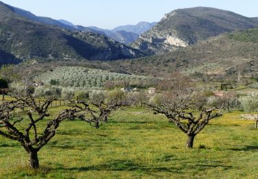
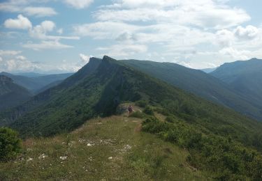
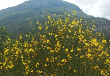
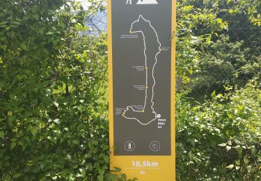
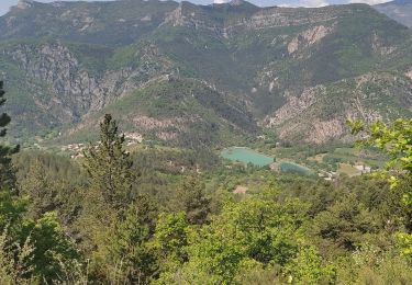
Randonnée Marche de 10,6 km à découvrir à Auvergne-Rhône-Alpes, Drôme, Saint-May. Cette randonnée est proposée par jeanneruols.
Description
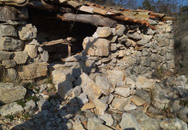
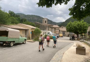
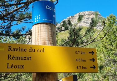
Partir de Remuzat vers le village de St May et monter jusqu'au ruine de l'abaye de Bodon t se garer au parking plus loin .
Localisation
Pays :
France
Région :
Auvergne-Rhône-Alpes
Département/Province :
Drôme
Commune :
Saint-May
Localité :
Unknown
Départ:(Dec)
Départ:(UTM)
686176 ; 4921717 (31T) N.
Commentaires
Randonnées à proximité
![Randonnée Marche Sahune - 26 sahune - Photo](https://media.geolcdn.com/t/375/260/a180cf7c-fb96-48c2-9d7c-76f8ea234985.jpg&format=jpg&maxdim=2)
![Marche Marche](https://static1.geolcdn.com/sitytour/trail-icons/101.png)
26 sahune
Marche
Moyen
Sahune,
Auvergne-Rhône-Alpes,
Drôme,
France
![](/images/other/stat-length.png)
19,5 km | 33 km-effort
7h 20min
![](https://static1.geolcdn.com/siteimages/upload/files/16400158638029165_repeat_loop_refresh_sync_direction_icon.png)
Non
![Randonnée Marche Rémuzat - les Aiguilles en partant de Remuzat - Photo](https://media.geolcdn.com/t/375/260/8caa209c-8d1c-426d-8ea8-486025dba5cb.jpg&format=jpg&maxdim=2)
![Marche Marche](https://static1.geolcdn.com/sitytour/trail-icons/101.png)
les Aiguilles en partant de Remuzat
Marche
Moyen
Rémuzat,
Auvergne-Rhône-Alpes,
Drôme,
France
![](/images/other/stat-length.png)
16 km | 29 km-effort
4h 45min
![](https://static1.geolcdn.com/siteimages/upload/files/16400158638029165_repeat_loop_refresh_sync_direction_icon.png)
Oui
![Randonnée Marche Villeperdrix - Villeperdrix-L'Angèle 13km - Photo](https://media.geolcdn.com/t/375/260/d0108719-7d5a-469c-a1d1-c0d5df953c3b.jpg&format=jpg&maxdim=2)
![Marche Marche](https://static1.geolcdn.com/sitytour/trail-icons/101.png)
Villeperdrix-L'Angèle 13km
Marche
Difficile
Villeperdrix,
Auvergne-Rhône-Alpes,
Drôme,
France
![](/images/other/stat-length.png)
13,5 km | 25 km-effort
5h 44min
![](https://static1.geolcdn.com/siteimages/upload/files/16400158638029165_repeat_loop_refresh_sync_direction_icon.png)
Oui
![Randonnée Marche nordique Rémuzat - Tour du Montrond - Photo](https://media.geolcdn.com/t/375/260/52f37003-9d49-438e-b061-694c5d6432f0.jpg&format=jpg&maxdim=2)
![Marche nordique Marche nordique](https://static1.geolcdn.com/sitytour/trail-icons/102.png)
Tour du Montrond
Marche nordique
Moyen
Rémuzat,
Auvergne-Rhône-Alpes,
Drôme,
France
![](/images/other/stat-length.png)
10,5 km | 18 km-effort
4h 19min
![](https://static1.geolcdn.com/siteimages/upload/files/16400158638029165_repeat_loop_refresh_sync_direction_icon.png)
Non
![Randonnée Marche Rémuzat - rocher du caire - Photo](https://media.geolcdn.com/t/375/260/60db15ec-1b2a-4873-b1d2-ea69db9a6899.jpg&format=jpg&maxdim=2)
![Marche Marche](https://static1.geolcdn.com/sitytour/trail-icons/101.png)
rocher du caire
Marche
Difficile
Rémuzat,
Auvergne-Rhône-Alpes,
Drôme,
France
![](/images/other/stat-length.png)
10,9 km | 20 km-effort
3h 48min
![](https://static1.geolcdn.com/siteimages/upload/files/16400158638029165_repeat_loop_refresh_sync_direction_icon.png)
Oui
![Randonnée Marche Rémuzat - Remuzat,les Aiguilles - Photo](https://media.geolcdn.com/t/375/260/65eeead4-8d80-4199-a271-fe368ccb3640.jpg&format=jpg&maxdim=2)
![Marche Marche](https://static1.geolcdn.com/sitytour/trail-icons/101.png)
Remuzat,les Aiguilles
Marche
Difficile
Rémuzat,
Auvergne-Rhône-Alpes,
Drôme,
France
![](/images/other/stat-length.png)
15,7 km | 29 km-effort
4h 36min
![](https://static1.geolcdn.com/siteimages/upload/files/16400158638029165_repeat_loop_refresh_sync_direction_icon.png)
Non
![Randonnée Marche Rémuzat - Remuzat,Montrond - Photo](https://media.geolcdn.com/t/375/260/d5105eda-5d82-4db9-863f-684adca80e89.jpg&format=jpg&maxdim=2)
![Marche Marche](https://static1.geolcdn.com/sitytour/trail-icons/101.png)
Remuzat,Montrond
Marche
Facile
Rémuzat,
Auvergne-Rhône-Alpes,
Drôme,
France
![](/images/other/stat-length.png)
10,3 km | 17,9 km-effort
2h 55min
![](https://static1.geolcdn.com/siteimages/upload/files/16400158638029165_repeat_loop_refresh_sync_direction_icon.png)
Oui
![Randonnée Marche Rémuzat - Remuzat rocher du Caire - Photo](https://media.geolcdn.com/t/375/260/ecb34409-e1c3-43df-949b-06dc24224bee.jpg&format=jpg&maxdim=2)
![Marche Marche](https://static1.geolcdn.com/sitytour/trail-icons/101.png)
Remuzat rocher du Caire
Marche
Difficile
Rémuzat,
Auvergne-Rhône-Alpes,
Drôme,
France
![](/images/other/stat-length.png)
11,3 km | 20 km-effort
3h 34min
![](https://static1.geolcdn.com/siteimages/upload/files/16400158638029165_repeat_loop_refresh_sync_direction_icon.png)
Oui
![Randonnée Marche La Motte-Chalancon - Boucle à Cornillon - Photo](https://media.geolcdn.com/t/375/260/68e11cbc-3244-4d5b-8d24-31101eb609ab.jpg&format=jpg&maxdim=2)
![Marche Marche](https://static1.geolcdn.com/sitytour/trail-icons/101.png)
Boucle à Cornillon
Marche
Moyen
(1)
La Motte-Chalancon,
Auvergne-Rhône-Alpes,
Drôme,
France
![](/images/other/stat-length.png)
10,7 km | 16,9 km-effort
3h 34min
![](https://static1.geolcdn.com/siteimages/upload/files/16400158638029165_repeat_loop_refresh_sync_direction_icon.png)
Oui