![](/images/other/stat-length.png)
![Randonnée V.T.T. Briis-sous-Forges - Briis, dim 02-11-14 - Photo](https://media.geolcdn.com/t/1900/400/ext.pjpeg?maxdim=2&url=https%3A%2F%2Fstatic1.geolcdn.com%2Fsiteimages%2Fupload%2Ffiles%2F1524743154velo.jpg)
Briis, dim 02-11-14
bde91
Utilisateur
![Longueur](/images/other/stat-length.png)
Longueur
37 km
![Altitude max](https://static1.geolcdn.com/siteimages/upload/files/1508320355ic_sort_altitude_max_24dp.png)
Altitude max
173 m
![Dénivelé positif](https://static1.geolcdn.com/siteimages/upload/files/1508320355ic_sort_den_pos_24dp.png)
Dénivelé positif
437 m
![Km-Effort](/images/other/stat-length.png)
Km-Effort
43 km
![Altitude min](https://static1.geolcdn.com/siteimages/upload/files/1508320355ic_sort_altitude_min_24dp.png)
Altitude min
68 m
![Dénivelé négatif](https://static1.geolcdn.com/siteimages/upload/files/1508320355ic_sort_den_neg_24dp.png)
Dénivelé négatif
434 m
![Boucle](https://static1.geolcdn.com/siteimages/upload/files/16400158638029165_repeat_loop_refresh_sync_direction_icon.png)
Boucle
Oui
Date de création :
2014-12-10 00:00:00.0
Dernière modification :
2014-12-10 00:00:00.0
![V.T.T.](https://static1.geolcdn.com/sitytour/trail-icons/202.png)
2h43
Difficulté : Facile
![Scannez ce code QR pour ouvrir la randonnée dans l'application SityTrail](https://capi.geolives.com/qq0zvz2zws4bq2lad0pu/sitytour/trails/359393/qr.png?size=200)
Application GPS de randonnée GRATUITE
À propos
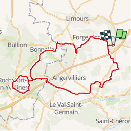
Randonnée V.T.T. de 37 km à découvrir à Île-de-France, Essonne, Briis-sous-Forges. Cette randonnée est proposée par bde91.
Description
Briis - Vaugrigneuse - La fontaine aux Cossons - La licorne - Bois d'Angervilliers - La Bâte - Rochefort - La Bâte - Bonnelles - Forges - Briis Avec compagnons de route du Marais
Localisation
Pays :
France
Région :
Île-de-France
Département/Province :
Essonne
Commune :
Briis-sous-Forges
Localité :
Unknown
Départ:(Dec)
Départ:(UTM)
435554 ; 5385699 (31U) N.
Commentaires
Randonnées à proximité
![Randonnée Marche Limours - Essonne_Tour_des_Fermes_de_la_Prédecelle - Photo](https://media.geolcdn.com/t/375/260/2a39169f-a228-484c-b261-d2ccff03535e.jpg&format=jpg&maxdim=2)
![Marche Marche](https://static1.geolcdn.com/sitytour/trail-icons/101.png)
Essonne_Tour_des_Fermes_de_la_Prédecelle
Marche
Très facile
(1)
Limours,
Île-de-France,
Essonne,
France
![](/images/other/stat-length.png)
12,9 km | 14,3 km-effort
3h 43min
![](https://static1.geolcdn.com/siteimages/upload/files/16400158638029165_repeat_loop_refresh_sync_direction_icon.png)
Oui
![Randonnée Marche Limours - Essonne_RD_Limours=>Viaduc=>Prédecelle=>Chaumusson - Photo](https://media.geolcdn.com/t/375/260/c60124a9-cca7-4dae-90e5-561e58250ffa.jpg&format=jpg&maxdim=2)
![Marche Marche](https://static1.geolcdn.com/sitytour/trail-icons/101.png)
Essonne_RD_Limours=>Viaduc=>Prédecelle=>Chaumusson
Marche
Facile
(1)
Limours,
Île-de-France,
Essonne,
France
![](/images/other/stat-length.png)
7,4 km | 8,4 km-effort
2h 30min
![](https://static1.geolcdn.com/siteimages/upload/files/16400158638029165_repeat_loop_refresh_sync_direction_icon.png)
Oui
![Randonnée Marche Limours - 20210319_Limours_Viaduc_Prédecelle_Amont - Photo](https://media.geolcdn.com/t/375/260/c60124a9-cca7-4dae-90e5-561e58250ffa.jpg&format=jpg&maxdim=2)
![Marche Marche](https://static1.geolcdn.com/sitytour/trail-icons/101.png)
20210319_Limours_Viaduc_Prédecelle_Amont
Marche
Facile
(1)
Limours,
Île-de-France,
Essonne,
France
![](/images/other/stat-length.png)
8,7 km | 9,9 km-effort
2h 30min
![](https://static1.geolcdn.com/siteimages/upload/files/16400158638029165_repeat_loop_refresh_sync_direction_icon.png)
Oui
![Randonnée Marche Courson-Monteloup - Boucle au départ du château de Courson - Photo](https://media.geolcdn.com/t/375/260/ed11977b-20c0-4900-b0e3-aa6abed829d7.jpg&format=jpg&maxdim=2)
![Marche Marche](https://static1.geolcdn.com/sitytour/trail-icons/101.png)
Boucle au départ du château de Courson
Marche
Facile
Courson-Monteloup,
Île-de-France,
Essonne,
France
![](/images/other/stat-length.png)
23 km | 27 km-effort
5h 7min
![](https://static1.geolcdn.com/siteimages/upload/files/16400158638029165_repeat_loop_refresh_sync_direction_icon.png)
Oui
![Randonnée Marche Bruyères-le-Châtel - Boucle Fontenay les Briis - Photo](https://media.geolcdn.com/t/375/260/1dc49ccb-e1a4-4ed8-a4eb-f6cdbc4809ff.jpg&format=jpg&maxdim=2)
![Marche Marche](https://static1.geolcdn.com/sitytour/trail-icons/101.png)
Boucle Fontenay les Briis
Marche
Très facile
Bruyères-le-Châtel,
Île-de-France,
Essonne,
France
![](/images/other/stat-length.png)
22 km | 26 km-effort
5h 4min
![](https://static1.geolcdn.com/siteimages/upload/files/16400158638029165_repeat_loop_refresh_sync_direction_icon.png)
Oui
![Randonnée Marche Saint-Maurice-Montcouronne - Boucle St Maurice Montcouronne - Brigitte - Photo](https://media.geolcdn.com/t/375/260/0e3ebb94-9c16-4bc9-9efb-ddbb902c3347.jpg&format=jpg&maxdim=2)
![Marche Marche](https://static1.geolcdn.com/sitytour/trail-icons/101.png)
Boucle St Maurice Montcouronne - Brigitte
Marche
Très facile
Saint-Maurice-Montcouronne,
Île-de-France,
Essonne,
France
![](/images/other/stat-length.png)
21 km | 24 km-effort
4h 19min
![](https://static1.geolcdn.com/siteimages/upload/files/16400158638029165_repeat_loop_refresh_sync_direction_icon.png)
Oui
![Randonnée V.T.T. Limours - St Arnoult 33km-2h30 - Photo](https://media.geolcdn.com/t/375/260/ext.jpg?maxdim=2&url=https%3A%2F%2Fstatic1.geolcdn.com%2Fsiteimages%2Fupload%2Ffiles%2F1524743154velo.jpg)
![V.T.T. V.T.T.](https://static1.geolcdn.com/sitytour/trail-icons/202.png)
St Arnoult 33km-2h30
V.T.T.
Difficile
(1)
Limours,
Île-de-France,
Essonne,
France
![](/images/other/stat-length.png)
34 km | 39 km-effort
2h 33min
![](https://static1.geolcdn.com/siteimages/upload/files/16400158638029165_repeat_loop_refresh_sync_direction_icon.png)
Oui
![Randonnée V.T.T. Fontenay-lès-Briis - Soucy / Le Marais - Photo](https://media.geolcdn.com/t/375/260/ext.jpg?maxdim=2&url=https%3A%2F%2Fstatic1.geolcdn.com%2Fsiteimages%2Fupload%2Ffiles%2F1524743154velo.jpg)
![V.T.T. V.T.T.](https://static1.geolcdn.com/sitytour/trail-icons/202.png)
Soucy / Le Marais
V.T.T.
Moyen
(2)
Fontenay-lès-Briis,
Île-de-France,
Essonne,
France
![](/images/other/stat-length.png)
25 km | 30 km-effort
1h 52min
![](https://static1.geolcdn.com/siteimages/upload/files/16400158638029165_repeat_loop_refresh_sync_direction_icon.png)
Oui
![Randonnée Marche Limours - Essonne_Limours=>Forges=>Briis - Photo](https://media.geolcdn.com/t/375/260/4141830d-45ac-4116-84db-97665bc0d173.jpg&format=jpg&maxdim=2)
![Marche Marche](https://static1.geolcdn.com/sitytour/trail-icons/101.png)
Essonne_Limours=>Forges=>Briis
Marche
Facile
Limours,
Île-de-France,
Essonne,
France
![](/images/other/stat-length.png)
10 km | 11,9 km-effort
3h 41min
![](https://static1.geolcdn.com/siteimages/upload/files/16400158638029165_repeat_loop_refresh_sync_direction_icon.png)
Oui