![](/images/other/stat-length.png)
![Randonnée Marche Rivolet - Rivolet (17 km - D. 675 m) - Photo](https://media.geolcdn.com/t/1900/400/ext.pjpeg?maxdim=2&url=https%3A%2F%2Fstatic1.geolcdn.com%2Fsiteimages%2Fupload%2Ffiles%2F1553511878bg_sport_marche.png)
Rivolet (17 km - D. 675 m)
Thomasdanielle
Utilisateur
![Longueur](/images/other/stat-length.png)
Longueur
17,2 km
![Altitude max](https://static1.geolcdn.com/siteimages/upload/files/1508320355ic_sort_altitude_max_24dp.png)
Altitude max
866 m
![Dénivelé positif](https://static1.geolcdn.com/siteimages/upload/files/1508320355ic_sort_den_pos_24dp.png)
Dénivelé positif
675 m
![Km-Effort](/images/other/stat-length.png)
Km-Effort
26 km
![Altitude min](https://static1.geolcdn.com/siteimages/upload/files/1508320355ic_sort_altitude_min_24dp.png)
Altitude min
338 m
![Dénivelé négatif](https://static1.geolcdn.com/siteimages/upload/files/1508320355ic_sort_den_neg_24dp.png)
Dénivelé négatif
675 m
![Boucle](https://static1.geolcdn.com/siteimages/upload/files/16400158638029165_repeat_loop_refresh_sync_direction_icon.png)
Boucle
Oui
Date de création :
2023-03-20 08:00:59.0
Dernière modification :
2023-03-22 09:30:21.522
![Marche](https://static1.geolcdn.com/sitytour/trail-icons/101.png)
4h46
Difficulté : Très difficile
![Scannez ce code QR pour ouvrir la randonnée dans l'application SityTrail](https://capi.geolives.com/qq0zvz2zws4bq2lad0pu/sitytour/trails/3591456/qr.png?size=200)
Application GPS de randonnée GRATUITE
À propos
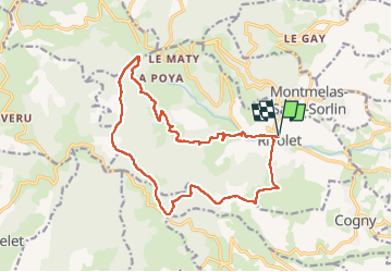
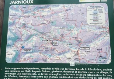
Randonnée Marche de 17,2 km à découvrir à Auvergne-Rhône-Alpes, Rhône, Rivolet. Cette randonnée est proposée par Thomasdanielle.
Description
D/A : Parking Cimetière
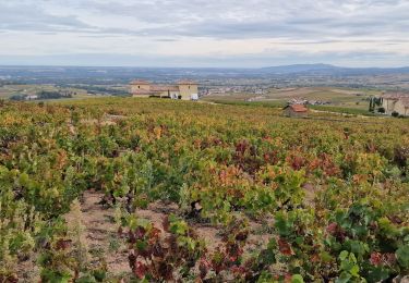
La première partie de la randonnée se passe sur une route (un peu longue à mon goût), il faut rester prudent et bien rester sur la droite.
Randonnée difficile il y a beaucoup de cailloux.
Localisation
Pays :
France
Région :
Auvergne-Rhône-Alpes
Département/Province :
Rhône
Commune :
Rivolet
Localité :
Unknown
Départ:(Dec)
Départ:(UTM)
623936 ; 5095999 (31T) N.
Commentaires
Randonnées à proximité
![Randonnée A pied Vaux-en-Beaujolais - Itinérant Beaujolais rouge étape 2 Le Flagolet - Odenas - Photo](https://media.geolcdn.com/t/375/260/e854eec2-8ed0-4512-9e04-68895c0881ec.jpg&format=jpg&maxdim=2)
![A pied A pied](https://static1.geolcdn.com/sitytour/trail-icons/100.png)
Itinérant Beaujolais rouge étape 2 Le Flagolet - Odenas
A pied
Très difficile
Vaux-en-Beaujolais,
Auvergne-Rhône-Alpes,
Rhône,
France
![](/images/other/stat-length.png)
22 km | 35 km-effort
7h 58min
![](https://static1.geolcdn.com/siteimages/upload/files/16400158638029165_repeat_loop_refresh_sync_direction_icon.png)
Non
![Randonnée Marche Montmelas-Saint-Sorlin - Col de Saint Bonnet (13-09-18) - Photo](https://media.geolcdn.com/t/375/260/ext.jpg?maxdim=2&url=https%3A%2F%2Fstatic1.geolcdn.com%2Fsiteimages%2Fupload%2Ffiles%2F1553511878bg_sport_marche.png)
![Marche Marche](https://static1.geolcdn.com/sitytour/trail-icons/101.png)
Col de Saint Bonnet (13-09-18)
Marche
Facile
(1)
Montmelas-Saint-Sorlin,
Auvergne-Rhône-Alpes,
Rhône,
France
![](/images/other/stat-length.png)
8,1 km | 11,9 km-effort
2h 29min
![](https://static1.geolcdn.com/siteimages/upload/files/16400158638029165_repeat_loop_refresh_sync_direction_icon.png)
Oui
![Randonnée Marche Saint-Cyr-le-Chatoux - Saint-cyr-le-Chatoux](https://media.geolcdn.com/t/375/260/ext.jpg?maxdim=2&url=https%3A%2F%2Fstatic1.geolcdn.com%2Fsiteimages%2Fupload%2Ffiles%2F1553511878bg_sport_marche.png)
![Marche Marche](https://static1.geolcdn.com/sitytour/trail-icons/101.png)
Saint-cyr-le-Chatoux "Les Agneaux"
Marche
Moyen
(2)
Saint-Cyr-le-Chatoux,
Auvergne-Rhône-Alpes,
Rhône,
France
![](/images/other/stat-length.png)
11,7 km | 16,7 km-effort
3h 45min
![](https://static1.geolcdn.com/siteimages/upload/files/16400158638029165_repeat_loop_refresh_sync_direction_icon.png)
Oui
![Randonnée Marche Rivolet - Rivolet - Photo](https://media.geolcdn.com/t/375/260/ext.jpg?maxdim=2&url=https%3A%2F%2Fstatic1.geolcdn.com%2Fsiteimages%2Fupload%2Ffiles%2F1553511878bg_sport_marche.png)
![Marche Marche](https://static1.geolcdn.com/sitytour/trail-icons/101.png)
Rivolet
Marche
Moyen
(2)
Rivolet,
Auvergne-Rhône-Alpes,
Rhône,
France
![](/images/other/stat-length.png)
11,1 km | 17,2 km-effort
3h 42min
![](https://static1.geolcdn.com/siteimages/upload/files/16400158638029165_repeat_loop_refresh_sync_direction_icon.png)
Non
![Randonnée Marche Lacenas - Lacenas (11 km - D 310 m) RG - Photo](https://media.geolcdn.com/t/375/260/620906a3-0ea4-4ca7-8578-340a8a98e518.jpg&format=jpg&maxdim=2)
![Marche Marche](https://static1.geolcdn.com/sitytour/trail-icons/101.png)
Lacenas (11 km - D 310 m) RG
Marche
Facile
Lacenas,
Auvergne-Rhône-Alpes,
Rhône,
France
![](/images/other/stat-length.png)
10,6 km | 14,7 km-effort
2h 38min
![](https://static1.geolcdn.com/siteimages/upload/files/16400158638029165_repeat_loop_refresh_sync_direction_icon.png)
Oui
![Randonnée Marche Porte des Pierres Dorées - Jarnioux (8,5 km - D. 249 m) - Photo](https://media.geolcdn.com/t/375/260/5f7dfffa-a5f2-424b-811f-de7ae78c4bcd.jpg&format=jpg&maxdim=2)
![Marche Marche](https://static1.geolcdn.com/sitytour/trail-icons/101.png)
Jarnioux (8,5 km - D. 249 m)
Marche
Porte des Pierres Dorées,
Auvergne-Rhône-Alpes,
Rhône,
France
![](/images/other/stat-length.png)
8,5 km | 11,8 km-effort
2h 42min
![](https://static1.geolcdn.com/siteimages/upload/files/16400158638029165_repeat_loop_refresh_sync_direction_icon.png)
Oui
![Randonnée Marche Porte des Pierres Dorées - Jarnioux 10.4 km - Photo](https://media.geolcdn.com/t/375/260/ext.jpg?maxdim=2&url=https%3A%2F%2Fservices.sitytrail.com%2FGeolivesWS%2FDownloadMedia.ashx%3FTrailID%3D885753%26Media%3D20180111164507.jpg)
![Marche Marche](https://static1.geolcdn.com/sitytour/trail-icons/101.png)
Jarnioux 10.4 km
Marche
Facile
Porte des Pierres Dorées,
Auvergne-Rhône-Alpes,
Rhône,
France
![](/images/other/stat-length.png)
10,4 km | 13,5 km-effort
2h 58min
![](https://static1.geolcdn.com/siteimages/upload/files/16400158638029165_repeat_loop_refresh_sync_direction_icon.png)
Oui
![Randonnée Marche Salles-Arbuissonnas-en-Beaujolais - Salles-Arbuissonnas-en-Beaujolais - Photo](https://media.geolcdn.com/t/375/260/ext.jpg?maxdim=2&url=https%3A%2F%2Fservices.sitytrail.com%2FGeolivesWS%2FDownloadMedia.ashx%3FTrailID%3D846815%26Media%3D20171016155238.jpg)
![Marche Marche](https://static1.geolcdn.com/sitytour/trail-icons/101.png)
Salles-Arbuissonnas-en-Beaujolais
Marche
Facile
Salles-Arbuissonnas-en-Beaujolais,
Auvergne-Rhône-Alpes,
Rhône,
France
![](/images/other/stat-length.png)
16,4 km | 23 km-effort
4h 55min
![](https://static1.geolcdn.com/siteimages/upload/files/16400158638029165_repeat_loop_refresh_sync_direction_icon.png)
Oui
![Randonnée Marche Denicé - Denicé (69) 11 km - D. 443 m - Photo](https://media.geolcdn.com/t/375/260/ext.jpg?maxdim=2&url=https%3A%2F%2Fservices.sitytrail.com%2FGeolivesWS%2FDownloadMedia.ashx%3FTrailID%3D717631%26Media%3D20161201161615.jpg)
![Marche Marche](https://static1.geolcdn.com/sitytour/trail-icons/101.png)
Denicé (69) 11 km - D. 443 m
Marche
Très facile
Denicé,
Auvergne-Rhône-Alpes,
Rhône,
France
![](/images/other/stat-length.png)
11,5 km | 17,4 km-effort
3h 17min
![](https://static1.geolcdn.com/siteimages/upload/files/16400158638029165_repeat_loop_refresh_sync_direction_icon.png)
Oui