![](/images/other/stat-length.png)
![Randonnée Marche nordique Cayeux-sur-Mer - Le Marais de Cayeux - Photo](https://media.geolcdn.com/t/1900/400/ext.pjpeg?maxdim=2&url=https%3A%2F%2Fstatic1.geolcdn.com%2Fsiteimages%2Fupload%2Ffiles%2F1545311037marcheuse_200dpi.jpg)
Le Marais de Cayeux
roselinemazeyrat
Utilisateur
![Longueur](/images/other/stat-length.png)
Longueur
9 km
![Altitude max](https://static1.geolcdn.com/siteimages/upload/files/1508320355ic_sort_altitude_max_24dp.png)
Altitude max
7 m
![Dénivelé positif](https://static1.geolcdn.com/siteimages/upload/files/1508320355ic_sort_den_pos_24dp.png)
Dénivelé positif
25 m
![Km-Effort](/images/other/stat-length.png)
Km-Effort
9,4 km
![Altitude min](https://static1.geolcdn.com/siteimages/upload/files/1508320355ic_sort_altitude_min_24dp.png)
Altitude min
1 m
![Dénivelé négatif](https://static1.geolcdn.com/siteimages/upload/files/1508320355ic_sort_den_neg_24dp.png)
Dénivelé négatif
26 m
![Boucle](https://static1.geolcdn.com/siteimages/upload/files/16400158638029165_repeat_loop_refresh_sync_direction_icon.png)
Boucle
Oui
Date de création :
2023-03-19 08:55:25.0
Dernière modification :
2023-03-19 14:06:55.832
![Marche nordique](https://static1.geolcdn.com/sitytour/trail-icons/102.png)
1h44
Difficulté : Très facile
![Scannez ce code QR pour ouvrir la randonnée dans l'application SityTrail](https://capi.geolives.com/qq0zvz2zws4bq2lad0pu/sitytour/trails/3589936/qr.png?size=200)
Application GPS de randonnée GRATUITE
À propos
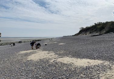
Randonnée Marche nordique de 9 km à découvrir à Hauts-de-France, Somme, Cayeux-sur-Mer. Cette randonnée est proposée par roselinemazeyrat.
Description
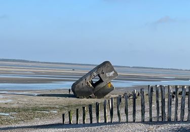
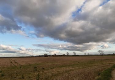
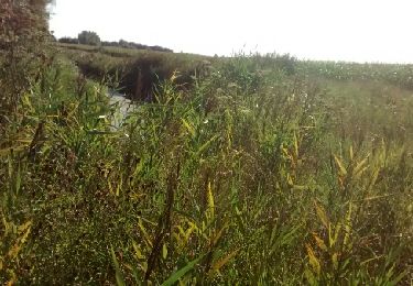
Le hameau du Marais comprend des habitations et des fermes. Les champs ont été gagnés sur la mer. L'usine de galets constitue la richesse industrielle de ce paysage de terres humides.
Localisation
Pays :
France
Région :
Hauts-de-France
Département/Province :
Somme
Commune :
Cayeux-sur-Mer
Localité :
Unknown
Départ:(Dec)
Départ:(UTM)
392720 ; 5558787 (31U) N.
Commentaires
Randonnées à proximité
![Randonnée Marche Cayeux-sur-Mer - Le Hourdel V2 - Photo](https://media.geolcdn.com/t/375/260/ext.jpg?maxdim=2&url=https%3A%2F%2Fservices.sitytrail.com%2FGeolivesWS%2FDownloadMedia.ashx%3FTrailID%3D108609%26Media%3D1517_1.jpg)
![Marche Marche](https://static1.geolcdn.com/sitytour/trail-icons/101.png)
Le Hourdel V2
Marche
Difficile
(1)
Cayeux-sur-Mer,
Hauts-de-France,
Somme,
France
![](/images/other/stat-length.png)
8 km | 8,4 km-effort
2h 30min
![](https://static1.geolcdn.com/siteimages/upload/files/16400158638029165_repeat_loop_refresh_sync_direction_icon.png)
Oui
![Randonnée V.T.T. Cayeux-sur-Mer - Baie de Somme - Cayeux-sur-Mer, Hourdel - Photo](https://media.geolcdn.com/t/375/260/dfc5e36a-a876-4158-8d07-2ca8055ddf3f.jpeg&format=jpg&maxdim=2)
![V.T.T. V.T.T.](https://static1.geolcdn.com/sitytour/trail-icons/202.png)
Baie de Somme - Cayeux-sur-Mer, Hourdel
V.T.T.
Facile
Cayeux-sur-Mer,
Hauts-de-France,
Somme,
France
![](/images/other/stat-length.png)
17 km | 17,7 km-effort
1h 13min
![](https://static1.geolcdn.com/siteimages/upload/files/16400158638029165_repeat_loop_refresh_sync_direction_icon.png)
Oui
![Randonnée Marche Cayeux-sur-Mer - entre le Hourdel et Cailleux - Photo](https://media.geolcdn.com/t/375/260/b237faa7-5642-4003-8111-9e6140f1adf8.jpg&format=jpg&maxdim=2)
![Marche Marche](https://static1.geolcdn.com/sitytour/trail-icons/101.png)
entre le Hourdel et Cailleux
Marche
Moyen
Cayeux-sur-Mer,
Hauts-de-France,
Somme,
France
![](/images/other/stat-length.png)
9,7 km | 10,3 km-effort
2h 28min
![](https://static1.geolcdn.com/siteimages/upload/files/16400158638029165_repeat_loop_refresh_sync_direction_icon.png)
Non
![Randonnée Marche Cayeux-sur-Mer - Crayeux sur mer - Photo](https://media.geolcdn.com/t/375/260/e74086ef-56e3-4ae1-8a72-f13407de6209.jpg&format=jpg&maxdim=2)
![Marche Marche](https://static1.geolcdn.com/sitytour/trail-icons/101.png)
Crayeux sur mer
Marche
Facile
Cayeux-sur-Mer,
Hauts-de-France,
Somme,
France
![](/images/other/stat-length.png)
4,6 km | 4,8 km-effort
50min
![](https://static1.geolcdn.com/siteimages/upload/files/16400158638029165_repeat_loop_refresh_sync_direction_icon.png)
Oui
![Randonnée A pied Cayeux-sur-Mer - Le Hourdel - Photo](https://media.geolcdn.com/t/375/260/e02b6736-5598-4803-9f59-ea4f4aaa2d0c.jpeg&format=jpg&maxdim=2)
![A pied A pied](https://static1.geolcdn.com/sitytour/trail-icons/100.png)
Le Hourdel
A pied
Facile
Cayeux-sur-Mer,
Hauts-de-France,
Somme,
France
![](/images/other/stat-length.png)
3,3 km | 3,4 km-effort
46min
![](https://static1.geolcdn.com/siteimages/upload/files/16400158638029165_repeat_loop_refresh_sync_direction_icon.png)
Non
![Randonnée Marche Cayeux-sur-Mer - lac de caouaisse . brighton . pointe de hourdel . lac de caouzisse - Photo](https://media.geolcdn.com/t/375/260/a2e73a68-b7d3-4fba-9ddd-e4c4d3c209b6.jpg&format=jpg&maxdim=2)
![Marche Marche](https://static1.geolcdn.com/sitytour/trail-icons/101.png)
lac de caouaisse . brighton . pointe de hourdel . lac de caouzisse
Marche
Facile
Cayeux-sur-Mer,
Hauts-de-France,
Somme,
France
![](/images/other/stat-length.png)
12,4 km | 13,1 km-effort
4h 28min
![](https://static1.geolcdn.com/siteimages/upload/files/16400158638029165_repeat_loop_refresh_sync_direction_icon.png)
Oui
![Randonnée Marche Lanchères - maison de l'oiseau - Photo](https://media.geolcdn.com/t/375/260/ext.jpg?maxdim=2&url=https%3A%2F%2Fservices.sitytrail.com%2FGeolivesWS%2FDownloadMedia.ashx%3FTrailID%3D462656%26Media%3Dfix__20150822180137.jpg)
![Marche Marche](https://static1.geolcdn.com/sitytour/trail-icons/101.png)
maison de l'oiseau
Marche
Très facile
Lanchères,
Hauts-de-France,
Somme,
France
![](/images/other/stat-length.png)
9,8 km | 10,2 km-effort
2h 33min
![](https://static1.geolcdn.com/siteimages/upload/files/16400158638029165_repeat_loop_refresh_sync_direction_icon.png)
Oui
![Randonnée Marche Cayeux-sur-Mer - le bourdel - Photo](https://media.geolcdn.com/t/375/260/ext.jpg?maxdim=2&url=https%3A%2F%2Fservices.sitytrail.com%2FGeolivesWS%2FDownloadMedia.ashx%3FTrailID%3D211221%26Media%3D20130808161402.jpg)
![Marche Marche](https://static1.geolcdn.com/sitytour/trail-icons/101.png)
le bourdel
Marche
Très facile
Cayeux-sur-Mer,
Hauts-de-France,
Somme,
France
![](/images/other/stat-length.png)
7,7 km | 8,1 km-effort
1h 56min
![](https://static1.geolcdn.com/siteimages/upload/files/16400158638029165_repeat_loop_refresh_sync_direction_icon.png)
Non
![Randonnée Marche Cayeux-sur-Mer - Le Hourdel - Photo](https://media.geolcdn.com/t/375/260/ext.jpg?maxdim=2&url=https%3A%2F%2Fstatic1.geolcdn.com%2Fsiteimages%2Fupload%2Ffiles%2F1553511878bg_sport_marche.png)
![Marche Marche](https://static1.geolcdn.com/sitytour/trail-icons/101.png)
Le Hourdel
Marche
Moyen
(2)
Cayeux-sur-Mer,
Hauts-de-France,
Somme,
France
![](/images/other/stat-length.png)
12,6 km | 13,2 km-effort
Inconnu
![](https://static1.geolcdn.com/siteimages/upload/files/16400158638029165_repeat_loop_refresh_sync_direction_icon.png)
Oui