![](/images/other/stat-length.png)
![Randonnée Marche Monthyon - Forêt de Montgé en Goêle 77 - Photo](https://media.geolcdn.com/t/1900/400/ext.pjpeg?maxdim=2&url=https%3A%2F%2Fstatic1.geolcdn.com%2Fsiteimages%2Fupload%2Ffiles%2F1553511878bg_sport_marche.png)
Forêt de Montgé en Goêle 77
GOELERANDO2
Utilisateur
![Longueur](/images/other/stat-length.png)
Longueur
9 km
![Altitude max](https://static1.geolcdn.com/siteimages/upload/files/1508320355ic_sort_altitude_max_24dp.png)
Altitude max
203 m
![Dénivelé positif](https://static1.geolcdn.com/siteimages/upload/files/1508320355ic_sort_den_pos_24dp.png)
Dénivelé positif
139 m
![Km-Effort](/images/other/stat-length.png)
Km-Effort
10,9 km
![Altitude min](https://static1.geolcdn.com/siteimages/upload/files/1508320355ic_sort_altitude_min_24dp.png)
Altitude min
103 m
![Dénivelé négatif](https://static1.geolcdn.com/siteimages/upload/files/1508320355ic_sort_den_neg_24dp.png)
Dénivelé négatif
151 m
![Boucle](https://static1.geolcdn.com/siteimages/upload/files/16400158638029165_repeat_loop_refresh_sync_direction_icon.png)
Boucle
Non
Date de création :
2023-03-17 16:58:08.577
Dernière modification :
2023-03-17 17:06:15.065
![Marche](https://static1.geolcdn.com/sitytour/trail-icons/101.png)
2h28
Difficulté : Moyen
![Scannez ce code QR pour ouvrir la randonnée dans l'application SityTrail](https://capi.geolives.com/qq0zvz2zws4bq2lad0pu/sitytour/trails/3588422/qr.png?size=200)
Application GPS de randonnée GRATUITE
À propos
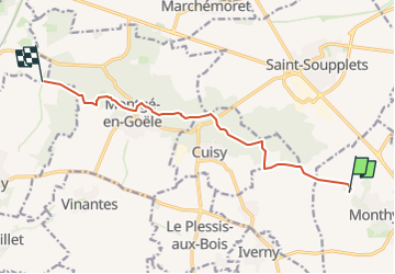
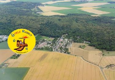
Randonnée Marche de 9 km à découvrir à Île-de-France, Seine-et-Marne, Monthyon. Cette randonnée est proposée par GOELERANDO2.
Description
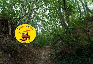
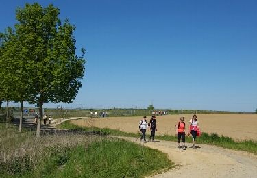
Traversée du bois de Montgé en Goêle depuis le plan d'eau de Monthyon au nord est du village.
Le chemin suit le GR 1
Localisation
Pays :
France
Région :
Île-de-France
Département/Province :
Seine-et-Marne
Commune :
Monthyon
Localité :
Unknown
Départ:(Dec)
Départ:(UTM)
486556 ; 5428816 (31U) N.
Commentaires
Randonnées à proximité
![Randonnée Marche Crégy-lès-Meaux - SM_CREGY-LES-MEAUX_8Km - Photo](https://media.geolcdn.com/t/375/260/4a1646b8-cb34-4e33-b775-fb442311006b.jpg&format=jpg&maxdim=2)
![Marche Marche](https://static1.geolcdn.com/sitytour/trail-icons/101.png)
SM_CREGY-LES-MEAUX_8Km
Marche
Moyen
(8)
Crégy-lès-Meaux,
Île-de-France,
Seine-et-Marne,
France
![](/images/other/stat-length.png)
7,8 km | 9,2 km-effort
2h 5min
![](https://static1.geolcdn.com/siteimages/upload/files/16400158638029165_repeat_loop_refresh_sync_direction_icon.png)
Oui
![Randonnée Marche Montgé-en-Goële - MR_MONTGE-en-GOELE_5.3Km - Photo](https://media.geolcdn.com/t/375/260/35addc96-117d-441b-96c3-8a9f60ce0ef4.jpg&format=jpg&maxdim=2)
![Marche Marche](https://static1.geolcdn.com/sitytour/trail-icons/101.png)
MR_MONTGE-en-GOELE_5.3Km
Marche
Moyen
(5)
Montgé-en-Goële,
Île-de-France,
Seine-et-Marne,
France
![](/images/other/stat-length.png)
5,3 km | 6,8 km-effort
1h 32min
![](https://static1.geolcdn.com/siteimages/upload/files/16400158638029165_repeat_loop_refresh_sync_direction_icon.png)
Oui
![Randonnée Marche Cuisy - SM_CUISY_7Km - Photo](https://media.geolcdn.com/t/375/260/6ba8652c-8bb0-4a43-980a-678cd2edacc0.jpg&format=jpg&maxdim=2)
![Marche Marche](https://static1.geolcdn.com/sitytour/trail-icons/101.png)
SM_CUISY_7Km
Marche
Moyen
(4)
Cuisy,
Île-de-France,
Seine-et-Marne,
France
![](/images/other/stat-length.png)
7 km | 8,7 km-effort
2h 21min
![](https://static1.geolcdn.com/siteimages/upload/files/16400158638029165_repeat_loop_refresh_sync_direction_icon.png)
Oui
![Randonnée Marche Montgé-en-Goële - SM_Montgé en Goële_8Km - Photo](https://media.geolcdn.com/t/375/260/512ace96-07d5-42e9-972d-de3ead1e1b12.jpg&format=jpg&maxdim=2)
![Marche Marche](https://static1.geolcdn.com/sitytour/trail-icons/101.png)
SM_Montgé en Goële_8Km
Marche
Moyen
(3)
Montgé-en-Goële,
Île-de-France,
Seine-et-Marne,
France
![](/images/other/stat-length.png)
8 km | 9,7 km-effort
2h 12min
![](https://static1.geolcdn.com/siteimages/upload/files/16400158638029165_repeat_loop_refresh_sync_direction_icon.png)
Oui
![Randonnée Marche Le Plessis-l'Évêque - MR_PLESSIS-L'EVEQUE_4.9Km - Photo](https://media.geolcdn.com/t/375/260/47f97308-fc93-4ea9-9c1c-fa82b0f1a452.jpg&format=jpg&maxdim=2)
![Marche Marche](https://static1.geolcdn.com/sitytour/trail-icons/101.png)
MR_PLESSIS-L'EVEQUE_4.9Km
Marche
Facile
(3)
Le Plessis-l'Évêque,
Île-de-France,
Seine-et-Marne,
France
![](/images/other/stat-length.png)
4,9 km | 5,5 km-effort
1h 12min
![](https://static1.geolcdn.com/siteimages/upload/files/16400158638029165_repeat_loop_refresh_sync_direction_icon.png)
Oui
![Randonnée Marche Monthyon - MR_MONTHYON_5.4Km - Photo](https://media.geolcdn.com/t/375/260/c92ecfa9-9d4d-4956-bac2-5b8e6acac2e2.jpg&format=jpg&maxdim=2)
![Marche Marche](https://static1.geolcdn.com/sitytour/trail-icons/101.png)
MR_MONTHYON_5.4Km
Marche
Moyen
(1)
Monthyon,
Île-de-France,
Seine-et-Marne,
France
![](/images/other/stat-length.png)
5,4 km | 6,4 km-effort
1h 24min
![](https://static1.geolcdn.com/siteimages/upload/files/16400158638029165_repeat_loop_refresh_sync_direction_icon.png)
Oui
![Randonnée Marche Montgé-en-Goële - Montgé en Goële SuperMiniRando - Photo](https://media.geolcdn.com/t/375/260/ext.jpg?maxdim=2&url=https%3A%2F%2Fstatic1.geolcdn.com%2Fsiteimages%2Fupload%2Ffiles%2F1553511878bg_sport_marche.png)
![Marche Marche](https://static1.geolcdn.com/sitytour/trail-icons/101.png)
Montgé en Goële SuperMiniRando
Marche
Facile
(1)
Montgé-en-Goële,
Île-de-France,
Seine-et-Marne,
France
![](/images/other/stat-length.png)
8 km | 9,6 km-effort
1h 59min
![](https://static1.geolcdn.com/siteimages/upload/files/16400158638029165_repeat_loop_refresh_sync_direction_icon.png)
Oui
![Randonnée Course à pied - Trail court - Chauconin 77124 - Photo](https://media.geolcdn.com/t/375/260/ext.jpg?maxdim=2&url=https%3A%2F%2Fstatic1.geolcdn.com%2Fsiteimages%2Fupload%2Ffiles%2F1524743154running.jpg)
![Course à pied Course à pied](https://static1.geolcdn.com/sitytour/trail-icons/103.png)
Trail court - Chauconin 77124
Course à pied
Difficile
(1)
,
Île-de-France,
Seine-et-Marne,
France
![](/images/other/stat-length.png)
21 km | 26 km-effort
2h 1min
![](https://static1.geolcdn.com/siteimages/upload/files/16400158638029165_repeat_loop_refresh_sync_direction_icon.png)
Oui
![Randonnée Marche Villeroy - Villeroy - Photo](https://media.geolcdn.com/t/375/260/ext.jpg?maxdim=2&url=https%3A%2F%2Fservices.sitytrail.com%2FGeolivesWS%2FDownloadMedia.ashx%3FTrailID%3D564103%26Media%3Dfix__20160505164010.jpg)
![Marche Marche](https://static1.geolcdn.com/sitytour/trail-icons/101.png)
Villeroy
Marche
Facile
(1)
Villeroy,
Île-de-France,
Seine-et-Marne,
France
![](/images/other/stat-length.png)
13,2 km | 14,8 km-effort
3h 15min
![](https://static1.geolcdn.com/siteimages/upload/files/16400158638029165_repeat_loop_refresh_sync_direction_icon.png)
Oui