Randonnée  Sainte-Marie - 2023-03-08_10h38m53_jersey-walk-3 - Photo

2023-03-08_10h38m53_jersey-walk-3

 danielletara
danielletara

Utilisateur

© OpenStreetMap contributors
Longueur
Longueur
19,8 km
Altitude max
Altitude max
120 m
Dénivelé positif
Dénivelé positif
373 m
Km-Effort
Km-Effort  
25 km
Altitude min
Altitude min
0 m
Dénivelé négatif
Dénivelé négatif
440 m
Boucle
Boucle
Non
Date de création :
2023-03-08 09:38:53.423
Dernière modification :
2023-03-08 09:38:56.598

(0 Avis)


Scannez ce code QR pour ouvrir la randonnée dans l'application SityTrail

Application GPS de randonnée GRATUITE

Logo SityTrail SityTrail

IGN / Instituts géographiques

Télécharger SityTrail sur l'App Store Télécharger SityTrail sur Google Play

Logo SityTrail SityTrail World

Le monde est à vous

Télécharger SityTrail sur l'App Store Télécharger SityTrail sur Google Play Télécharger SityTrail sur Huawei AppGallery

À propos

Randonnée de 19,8 km à découvrir à Inconnu, Inconnu, Sainte-Marie. Cette randonnée est proposée par danielletara.

Description

Devil's Hole > Bonne Nuit > St Helier > Free Tower

Profil altimétrique

Localisation

Pays :
Jersey
Région :
Inconnu
Département/Province :
Inconnu
Commune :
Sainte-Marie
Localité :
Vigntaine du Nord
Départ:(UTM)
560554 ; 5455579 (30U) N.

Randonnées à proximité

Randonnée Marche Saint-Jean - Rando St John's- Zoo 12km - Photo
Marche
GUIDE
jeanmarcMasson

Marche

Difficile
Saint-Jean, Inconnu, Inconnu, Jersey
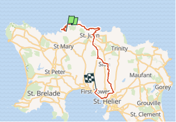
11,5 km | 16,7 km-effort
3h 17min
Non
Randonnée Marche Saint-Jean - rando Jersey St John's- l'Etacq- 17 km - Photo
Marche
GUIDE
jeanmarcMasson

Marche

Très difficile
Saint-Jean, Inconnu, Inconnu, Jersey
18 km | 22 km-effort
4h 48min
Non
Randonnée sport Sainte-Marie - 2023-03-21_09h38m21_jersey-walk-3 - Photo
sport
danielletara

sport

Très facile
Sainte-Marie, Inconnu, Inconnu, Jersey
19,8 km | 25 km-effort
Inconnu
Non


Fermer
Mes abonnements