![](/images/other/stat-length.png)
![Randonnée Marche Réthy - Une journée en boucle à patir de Retie - Photo](https://media.geolcdn.com/t/1900/400/794c2ddf-1fbc-4956-9c17-fa859e2fec79.jpg&format=pjpeg&maxdim=2)
Une journée en boucle à patir de Retie
Charles Lemaire
Utilisateur GUIDE
![Longueur](/images/other/stat-length.png)
Longueur
25 km
![Altitude max](https://static1.geolcdn.com/siteimages/upload/files/1508320355ic_sort_altitude_max_24dp.png)
Altitude max
35 m
![Dénivelé positif](https://static1.geolcdn.com/siteimages/upload/files/1508320355ic_sort_den_pos_24dp.png)
Dénivelé positif
136 m
![Km-Effort](/images/other/stat-length.png)
Km-Effort
27 km
![Altitude min](https://static1.geolcdn.com/siteimages/upload/files/1508320355ic_sort_altitude_min_24dp.png)
Altitude min
17 m
![Dénivelé négatif](https://static1.geolcdn.com/siteimages/upload/files/1508320355ic_sort_den_neg_24dp.png)
Dénivelé négatif
135 m
![Boucle](https://static1.geolcdn.com/siteimages/upload/files/16400158638029165_repeat_loop_refresh_sync_direction_icon.png)
Boucle
Oui
Date de création :
2023-03-07 09:37:26.248
Dernière modification :
2023-03-09 18:36:41.233
![Marche](https://static1.geolcdn.com/sitytour/trail-icons/101.png)
6h12
Difficulté : Très difficile
![Scannez ce code QR pour ouvrir la randonnée dans l'application SityTrail](https://capi.geolives.com/qq0zvz2zws4bq2lad0pu/sitytour/trails/3576962/qr.png?size=200)
Application GPS de randonnée GRATUITE
À propos
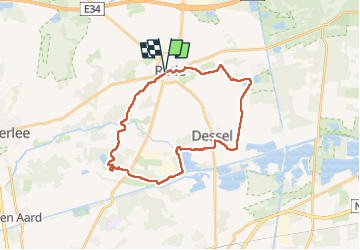
Randonnée Marche de 25 km à découvrir à Flandre, Anvers, Réthy. Cette randonnée est proposée par Charles Lemaire.
Description
Une belle promenade, variée
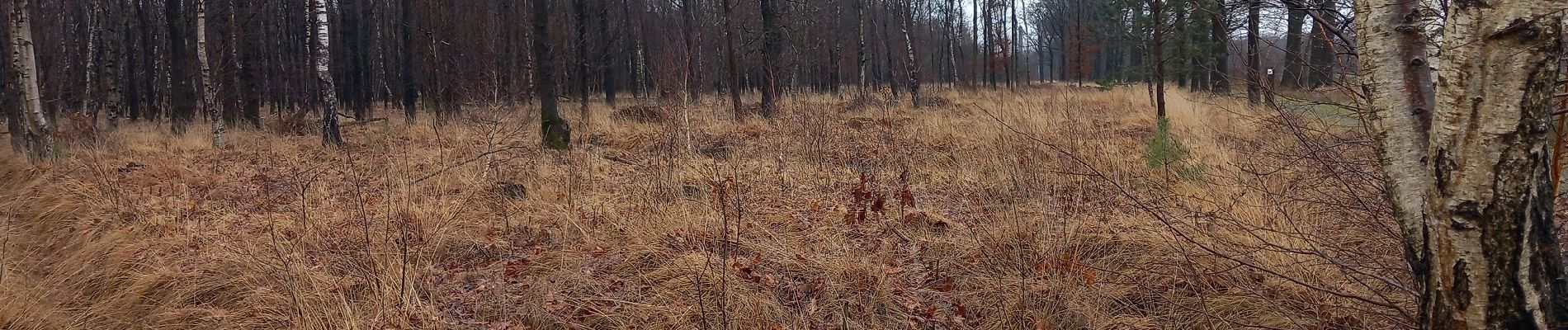
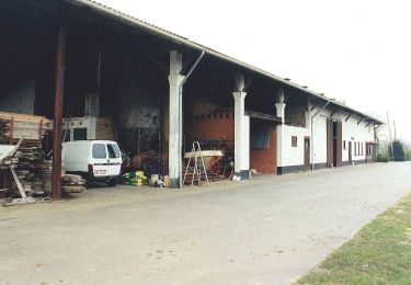
Des rivières qui retrouvent leur cours ; des activités industrielles, et même nucléaires ; et de sympathiques passages en forêt.
Attention... quand il fait humide... le sol est vraiment très humide...
Localisation
Pays :
Belgique
Région :
Flandre
Département/Province :
Anvers
Commune :
Réthy
Localité :
Unknown
Départ:(Dec)
Départ:(UTM)
645219 ; 5681572 (31U) N.
Commentaires
Randonnées à proximité
![Randonnée A pied Réthy - Blauwe Wandeling - Photo](https://media.geolcdn.com/t/375/260/1a70ad8d-5156-4876-879f-c12f0fedd150.jpeg&format=jpg&maxdim=2)
![A pied A pied](https://static1.geolcdn.com/sitytour/trail-icons/100.png)
![Randonnée Vélo Réthy - f-belgie-prinsenroute - Photo](https://media.geolcdn.com/t/375/260/ext.jpg?maxdim=2&url=https%3A%2F%2Fstatic1.geolcdn.com%2Fsiteimages%2Fupload%2Ffiles%2F1524743154velo.jpg)
![Vélo Vélo](https://static1.geolcdn.com/sitytour/trail-icons/200.png)
f-belgie-prinsenroute
Vélo
Très facile
Réthy,
Flandre,
Anvers,
Belgique
![](/images/other/stat-length.png)
46 km | 49 km-effort
Inconnu
![](https://static1.geolcdn.com/siteimages/upload/files/16400158638029165_repeat_loop_refresh_sync_direction_icon.png)
Oui
![Randonnée V.T.T. Dessel - m-belgie-vaste-mtbroute-dessel-groen-rood - Photo](https://media.geolcdn.com/t/375/260/ext.jpg?maxdim=2&url=https%3A%2F%2Fstatic1.geolcdn.com%2Fsiteimages%2Fupload%2Ffiles%2F1524743154velo.jpg)
![V.T.T. V.T.T.](https://static1.geolcdn.com/sitytour/trail-icons/202.png)
m-belgie-vaste-mtbroute-dessel-groen-rood
V.T.T.
Très facile
Dessel,
Flandre,
Anvers,
Belgique
![](/images/other/stat-length.png)
41 km | 44 km-effort
Inconnu
![](https://static1.geolcdn.com/siteimages/upload/files/16400158638029165_repeat_loop_refresh_sync_direction_icon.png)
Non
![Randonnée Marche Dessel - Belgie - GR Kempen 7 - Photo](https://media.geolcdn.com/t/375/260/ext.jpg?maxdim=2&url=https%3A%2F%2Fstatic1.geolcdn.com%2Fsiteimages%2Fupload%2Ffiles%2F1553511878bg_sport_marche.png)
![Marche Marche](https://static1.geolcdn.com/sitytour/trail-icons/101.png)
Belgie - GR Kempen 7
Marche
Très facile
Dessel,
Flandre,
Anvers,
Belgique
![](/images/other/stat-length.png)
26 km | 28 km-effort
Inconnu
![](https://static1.geolcdn.com/siteimages/upload/files/16400158638029165_repeat_loop_refresh_sync_direction_icon.png)
Non
![Randonnée Marche Réthy - Retie naar watermolen - 9 km RT - Photo](https://media.geolcdn.com/t/375/260/ext.jpg?maxdim=2&url=https%3A%2F%2Fstatic1.geolcdn.com%2Fsiteimages%2Fupload%2Ffiles%2F1553511878bg_sport_marche.png)
![Marche Marche](https://static1.geolcdn.com/sitytour/trail-icons/101.png)
Retie naar watermolen - 9 km RT
Marche
Très facile
Réthy,
Flandre,
Anvers,
Belgique
![](/images/other/stat-length.png)
9,1 km | 9,9 km-effort
Inconnu
![](https://static1.geolcdn.com/siteimages/upload/files/16400158638029165_repeat_loop_refresh_sync_direction_icon.png)
Oui
![Randonnée Marche Réthy - Retie Het warme Netepad - 5 km RT - Photo](https://media.geolcdn.com/t/375/260/ext.jpg?maxdim=2&url=https%3A%2F%2Fstatic1.geolcdn.com%2Fsiteimages%2Fupload%2Ffiles%2F1553511878bg_sport_marche.png)
![Marche Marche](https://static1.geolcdn.com/sitytour/trail-icons/101.png)
Retie Het warme Netepad - 5 km RT
Marche
Très facile
Réthy,
Flandre,
Anvers,
Belgique
![](/images/other/stat-length.png)
4,8 km | 5,1 km-effort
Inconnu
![](https://static1.geolcdn.com/siteimages/upload/files/16400158638029165_repeat_loop_refresh_sync_direction_icon.png)
Oui
![Randonnée Marche Réthy - Retie door Prinsenpark - 10 km RT - Photo](https://media.geolcdn.com/t/375/260/ext.jpg?maxdim=2&url=https%3A%2F%2Fstatic1.geolcdn.com%2Fsiteimages%2Fupload%2Ffiles%2F1553511878bg_sport_marche.png)
![Marche Marche](https://static1.geolcdn.com/sitytour/trail-icons/101.png)
Retie door Prinsenpark - 10 km RT
Marche
Très facile
Réthy,
Flandre,
Anvers,
Belgique
![](/images/other/stat-length.png)
9,9 km | 10,8 km-effort
Inconnu
![](https://static1.geolcdn.com/siteimages/upload/files/16400158638029165_repeat_loop_refresh_sync_direction_icon.png)
Oui
![Randonnée Marche Réthy - Kasterlee Rondom Hooibeek - 6 km RT - Photo](https://media.geolcdn.com/t/375/260/ext.jpg?maxdim=2&url=https%3A%2F%2Fstatic1.geolcdn.com%2Fsiteimages%2Fupload%2Ffiles%2F1553511878bg_sport_marche.png)
![Marche Marche](https://static1.geolcdn.com/sitytour/trail-icons/101.png)
Kasterlee Rondom Hooibeek - 6 km RT
Marche
Très facile
Réthy,
Flandre,
Anvers,
Belgique
![](/images/other/stat-length.png)
5,9 km | 6,6 km-effort
Inconnu
![](https://static1.geolcdn.com/siteimages/upload/files/16400158638029165_repeat_loop_refresh_sync_direction_icon.png)
Oui
![Randonnée Marche Réthy - Kasterlee - Photo](https://media.geolcdn.com/t/375/260/ext.jpg?maxdim=2&url=https%3A%2F%2Fstatic1.geolcdn.com%2Fsiteimages%2Fupload%2Ffiles%2F1553511878bg_sport_marche.png)
![Marche Marche](https://static1.geolcdn.com/sitytour/trail-icons/101.png)