![](/images/other/stat-length.png)
![Randonnée Vélo de route La Ciotat - la Ciotat la cadière st cyr - Photo](https://media.geolcdn.com/t/1900/400/ext.pjpeg?maxdim=2&url=https%3A%2F%2Fstatic1.geolcdn.com%2Fsiteimages%2Fupload%2Ffiles%2F1524743154velo.jpg)
la Ciotat la cadière st cyr
jlnessy
Utilisateur
![Longueur](/images/other/stat-length.png)
Longueur
32 km
![Altitude max](https://static1.geolcdn.com/siteimages/upload/files/1508320355ic_sort_altitude_max_24dp.png)
Altitude max
176 m
![Dénivelé positif](https://static1.geolcdn.com/siteimages/upload/files/1508320355ic_sort_den_pos_24dp.png)
Dénivelé positif
457 m
![Km-Effort](/images/other/stat-length.png)
Km-Effort
39 km
![Altitude min](https://static1.geolcdn.com/siteimages/upload/files/1508320355ic_sort_altitude_min_24dp.png)
Altitude min
0 m
![Dénivelé négatif](https://static1.geolcdn.com/siteimages/upload/files/1508320355ic_sort_den_neg_24dp.png)
Dénivelé négatif
457 m
![Boucle](https://static1.geolcdn.com/siteimages/upload/files/16400158638029165_repeat_loop_refresh_sync_direction_icon.png)
Boucle
Oui
Date de création :
2023-03-05 08:40:54.636
Dernière modification :
2023-03-05 14:23:51.449
![Vélo de route](https://static1.geolcdn.com/sitytour/trail-icons/201.png)
5h40
Difficulté : Moyen
![Scannez ce code QR pour ouvrir la randonnée dans l'application SityTrail](https://capi.geolives.com/qq0zvz2zws4bq2lad0pu/sitytour/trails/3574234/qr.png?size=200)
Application GPS de randonnée GRATUITE
À propos
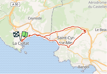
Randonnée Vélo de route de 32 km à découvrir à Provence-Alpes-Côte d'Azur, Bouches-du-Rhône, La Ciotat. Cette randonnée est proposée par jlnessy.
Description
tour vélo par les petites routes. des belles petites montées et descentes avec pique nique à la Cadière 32 km
Localisation
Pays :
France
Région :
Provence-Alpes-Côte d'Azur
Département/Province :
Bouches-du-Rhône
Commune :
La Ciotat
Localité :
Unknown
Départ:(Dec)
Départ:(UTM)
711869 ; 4784068 (31T) N.
Commentaires
Randonnées à proximité
![Randonnée Marche Ceyreste - Autour du Montounier 2eme version - Photo](https://media.geolcdn.com/t/375/260/aea50e59-26c4-4704-b6d5-ac40178213cc.jpg&format=jpg&maxdim=2)
![Marche Marche](https://static1.geolcdn.com/sitytour/trail-icons/101.png)
Autour du Montounier 2eme version
Marche
Moyen
(1)
Ceyreste,
Provence-Alpes-Côte d'Azur,
Bouches-du-Rhône,
France
![](/images/other/stat-length.png)
15,7 km | 24 km-effort
6h 0min
![](https://static1.geolcdn.com/siteimages/upload/files/16400158638029165_repeat_loop_refresh_sync_direction_icon.png)
Oui
![Randonnée Marche Cassis - Cassis - La couronne de Charlemagne - Cap canaille - Photo](https://media.geolcdn.com/t/375/260/3dbefdc1-c4a5-41cb-82fb-882826196b25.jpg&format=jpg&maxdim=2)
![Marche Marche](https://static1.geolcdn.com/sitytour/trail-icons/101.png)
Cassis - La couronne de Charlemagne - Cap canaille
Marche
Moyen
(3)
Cassis,
Provence-Alpes-Côte d'Azur,
Bouches-du-Rhône,
France
![](/images/other/stat-length.png)
16,1 km | 24 km-effort
6h 0min
![](https://static1.geolcdn.com/siteimages/upload/files/16400158638029165_repeat_loop_refresh_sync_direction_icon.png)
Oui
![Randonnée Marche La Ciotat - La Ciotat - Chapelle Ste Anne - Ruines villas - Semaphore - Bau Rous - Pont naturel - Dent du chat - Photo](https://media.geolcdn.com/t/375/260/c2e971e1-4dc5-4d98-ad78-ef6aa6ab5b4d.jpg&format=jpg&maxdim=2)
![Marche Marche](https://static1.geolcdn.com/sitytour/trail-icons/101.png)
La Ciotat - Chapelle Ste Anne - Ruines villas - Semaphore - Bau Rous - Pont n...
Marche
Difficile
(1)
La Ciotat,
Provence-Alpes-Côte d'Azur,
Bouches-du-Rhône,
France
![](/images/other/stat-length.png)
12,1 km | 19,9 km-effort
7h 30min
![](https://static1.geolcdn.com/siteimages/upload/files/16400158638029165_repeat_loop_refresh_sync_direction_icon.png)
Oui
![Randonnée Marche La Ciotat - la ciotat - Photo](https://media.geolcdn.com/t/375/260/254a0458-8edc-4154-b242-76a735e7c994.jpg&format=jpg&maxdim=2)
![Marche Marche](https://static1.geolcdn.com/sitytour/trail-icons/101.png)
la ciotat
Marche
Très facile
(1)
La Ciotat,
Provence-Alpes-Côte d'Azur,
Bouches-du-Rhône,
France
![](/images/other/stat-length.png)
6,2 km | 9,3 km-effort
3h 21min
![](https://static1.geolcdn.com/siteimages/upload/files/16400158638029165_repeat_loop_refresh_sync_direction_icon.png)
Oui
![Randonnée Marche La Ciotat - Balade La Ciotat - Photo](https://media.geolcdn.com/t/375/260/ext.jpg?maxdim=2&url=https%3A%2F%2Fstatic1.geolcdn.com%2Fsiteimages%2Fupload%2Ffiles%2F1553511878bg_sport_marche.png)
![Marche Marche](https://static1.geolcdn.com/sitytour/trail-icons/101.png)
Balade La Ciotat
Marche
Difficile
(1)
La Ciotat,
Provence-Alpes-Côte d'Azur,
Bouches-du-Rhône,
France
![](/images/other/stat-length.png)
8,8 km | 14 km-effort
3h 7min
![](https://static1.geolcdn.com/siteimages/upload/files/16400158638029165_repeat_loop_refresh_sync_direction_icon.png)
Oui
![Randonnée Marche La Ciotat - Cap Canaille - Photo](https://media.geolcdn.com/t/375/260/ext.jpg?maxdim=2&url=https%3A%2F%2Fstatic1.geolcdn.com%2Fsiteimages%2Fupload%2Ffiles%2F1553511878bg_sport_marche.png)
![Marche Marche](https://static1.geolcdn.com/sitytour/trail-icons/101.png)
Cap Canaille
Marche
Moyen
(1)
La Ciotat,
Provence-Alpes-Côte d'Azur,
Bouches-du-Rhône,
France
![](/images/other/stat-length.png)
10,2 km | 16,2 km-effort
4h 0min
![](https://static1.geolcdn.com/siteimages/upload/files/16400158638029165_repeat_loop_refresh_sync_direction_icon.png)
Oui
![Randonnée Marche Ceyreste - Ceyreste/Montounier - Photo](https://media.geolcdn.com/t/375/260/ext.jpg?maxdim=2&url=https%3A%2F%2Fstatic1.geolcdn.com%2Fsiteimages%2Fupload%2Ffiles%2F1553511878bg_sport_marche.png)
![Marche Marche](https://static1.geolcdn.com/sitytour/trail-icons/101.png)
Ceyreste/Montounier
Marche
Moyen
(1)
Ceyreste,
Provence-Alpes-Côte d'Azur,
Bouches-du-Rhône,
France
![](/images/other/stat-length.png)
8,9 km | 14 km-effort
2h 54min
![](https://static1.geolcdn.com/siteimages/upload/files/16400158638029165_repeat_loop_refresh_sync_direction_icon.png)
Oui
![Randonnée V.T.T. Ceyreste - ceyreste - Photo](https://media.geolcdn.com/t/375/260/ext.jpg?maxdim=2&url=https%3A%2F%2Fstatic1.geolcdn.com%2Fsiteimages%2Fupload%2Ffiles%2F1524743154velo.jpg)
![V.T.T. V.T.T.](https://static1.geolcdn.com/sitytour/trail-icons/202.png)
ceyreste
V.T.T.
Moyen
(1)
Ceyreste,
Provence-Alpes-Côte d'Azur,
Bouches-du-Rhône,
France
![](/images/other/stat-length.png)
19,2 km | 28 km-effort
2h 0min
![](https://static1.geolcdn.com/siteimages/upload/files/16400158638029165_repeat_loop_refresh_sync_direction_icon.png)
Oui
![Randonnée Marche La Ciotat - Traversée Philémon au Cap Canaille - Photo](https://media.geolcdn.com/t/375/260/328b3375-8fff-494b-99b1-71e7183a95a0.jpg&format=jpg&maxdim=2)
![Marche Marche](https://static1.geolcdn.com/sitytour/trail-icons/101.png)
Traversée Philémon au Cap Canaille
Marche
Très difficile
La Ciotat,
Provence-Alpes-Côte d'Azur,
Bouches-du-Rhône,
France
![](/images/other/stat-length.png)
3,6 km | 7,6 km-effort
4h 30min
![](https://static1.geolcdn.com/siteimages/upload/files/16400158638029165_repeat_loop_refresh_sync_direction_icon.png)
Non