Randonnée Marche Nailhac - Boucle de Nailhac  - Photo
 swp648
swp648

Utilisateur

© OpenStreetMap contributors
Longueur
Longueur
11,7 km
Altitude max
Altitude max
321 m
Dénivelé positif
Dénivelé positif
244 m
Km-Effort
Km-Effort  
14,9 km
Altitude min
Altitude min
196 m
Dénivelé négatif
Dénivelé négatif
243 m
Boucle
Boucle
Oui
Date de création :
2023-03-05 07:59:12.947
Dernière modification :
2023-03-05 11:42:29.099

(0 Avis)

Marche
Marche
2h54
Difficulté : Facile

Scannez ce code QR pour ouvrir la randonnée dans l'application SityTrail

Application GPS de randonnée GRATUITE

Logo SityTrail SityTrail

IGN / Instituts géographiques

Télécharger SityTrail sur l'App Store Télécharger SityTrail sur Google Play

Logo SityTrail SityTrail World

Le monde est à vous

Télécharger SityTrail sur l'App Store Télécharger SityTrail sur Google Play Télécharger SityTrail sur Huawei AppGallery

À propos

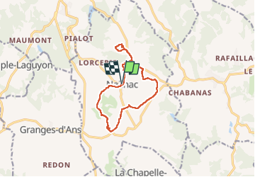
Randonnée Marche de 11,7 km à découvrir à Nouvelle-Aquitaine, Dordogne, Nailhac. Cette randonnée est proposée par swp648.

Description

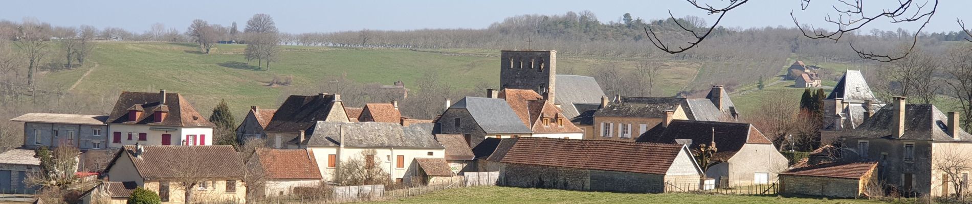
Une très belle randonnée avec des panoramas à 380°, belles bâtisses, de magnifiques plantations de noyer, vues sur le château d'Hautefort.

Profil altimétrique

Photos

Localisation

Pays :
France
Région :
Nouvelle-Aquitaine
Département/Province :
Dordogne
Commune :
Nailhac
Localité :
Unknown
Départ:(Dec)
Départ:(UTM)
355037 ; 5009803 (31T) N.

Randonnées à proximité

Randonnée Marche Granges-d'Ans - Granges d'Ans- Paysage et nature  - Photo
Marche
houbart

Marche

Difficile
Granges-d'Ans, Nouvelle-Aquitaine, Dordogne, France
11,8 km | 15 km-effort
3h 24min
Oui
Randonnée V.T.T. La Chapelle-Saint-Jean - La Chapelle Saint Jean - Photo
V.T.T.
heyoka

V.T.T.

Facile
La Chapelle-Saint-Jean, Nouvelle-Aquitaine, Dordogne, France
11,7 km | 14,7 km-effort
3h 20min
Non
Randonnée V.T.T. La Chapelle-Saint-Jean - 2 - Photo
V.T.T.
christophe binet

V.T.T.

Très difficile
La Chapelle-Saint-Jean, Nouvelle-Aquitaine, Dordogne, France
41 km | 52 km-effort
1h 47min
Non
Randonnée Marche Châtres - boucle chatres - Photo
Marche
fab0202

Marche

Facile
(1)
Châtres, Nouvelle-Aquitaine, Dordogne, France
10,9 km | 14,7 km-effort
2h 42min
Oui
Randonnée A pied Nailhac - Nailhac Noix allongée 11km - Photo
A pied
YV24

A pied

Facile
(2)
Nailhac, Nouvelle-Aquitaine, Dordogne, France
11,1 km | 14,2 km-effort
Inconnu
Oui
Randonnée Marche Saint-Rabier - chateau coderc - Photo
Marche
personono

Marche

Facile
Saint-Rabier, Nouvelle-Aquitaine, Dordogne, France
7,1 km | 9 km-effort
1h 52min
Oui
Randonnée Marche Nailhac - Chassaignas La Chapelle St Jean 12km - Photo
Marche
YV24

Marche

Facile
Nailhac, Nouvelle-Aquitaine, Dordogne, France
11,9 km | 15,2 km-effort
3h 16min
Oui
Randonnée Marche Saint-Rabier - Gd Coderc Grange d'Ans 12 km - Photo
Marche
YV24

Marche

Facile
Saint-Rabier, Nouvelle-Aquitaine, Dordogne, France
11,7 km | 15,5 km-effort
3h 18min
Oui
Randonnée Marche Hautefort - HAUTEFORT Milpas court - Photo
Marche
pascalmilpas

Marche

Difficile
Hautefort, Nouvelle-Aquitaine, Dordogne, France
10 km | 12,9 km-effort
2h 29min
Oui


Fermer
Mes abonnements