Randonnée Marche Châtelus - F38 ST Chatelus Voute Allier - Photo

F38 ST Chatelus Voute Allier

 ageo
ageo

Utilisateur

© OpenStreetMap contributors
Longueur
Longueur
13,6 km
Altitude max
Altitude max
1259 m
Dénivelé positif
Dénivelé positif
1045 m
Km-Effort
Km-Effort  
28 km
Altitude min
Altitude min
531 m
Dénivelé négatif
Dénivelé négatif
1044 m
Boucle
Boucle
Oui
Date de création :
2017-06-05 00:00:00.0
Dernière modification :
2017-06-05 00:00:00.0

(0 Avis)

Marche
Marche
4h41
Difficulté : Moyen

Scannez ce code QR pour ouvrir la randonnée dans l'application SityTrail

Application GPS de randonnée GRATUITE

Logo SityTrail SityTrail

IGN / Instituts géographiques

Télécharger SityTrail sur l'App Store Télécharger SityTrail sur Google Play

Logo SityTrail SityTrail World

Le monde est à vous

Télécharger SityTrail sur l'App Store Télécharger SityTrail sur Google Play Télécharger SityTrail sur Huawei AppGallery

À propos

Randonnée Marche de 13,6 km à découvrir à Auvergne-Rhône-Alpes, Isère, Châtelus. Cette randonnée est proposée par ageo.

Profil altimétrique

Photos

Points d'intérêt

Point d'intérêt Saint-Julien-en-Vercors - Point 1 - Photo
ageo
SAINT-JULIEN-EN-VERCORS 

Localisation

Pays :
France
Région :
Auvergne-Rhône-Alpes
Département/Province :
Isère
Commune :
Châtelus
Localité :
Unknown
Départ:(Dec)
Départ:(UTM)
686442 ; 4991572 (31T) N.

Randonnées à proximité

Randonnée Marche Châtelus - 38 bournillon porte du diable charmatte - Photo
Marche
GUIDE
randodyssée

Marche

Difficile
(1)
Châtelus, Auvergne-Rhône-Alpes, Isère, France
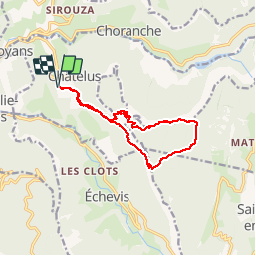
16,5 km | 34 km-effort
8h 7min
Oui
Randonnée Marche Châtelus - Boucle Pas de l'Allier - Pas des Voutes - Photo
Marche
tracegps

Marche

Moyen
(1)
Châtelus, Auvergne-Rhône-Alpes, Isère, France
10,1 km | 22 km-effort
4h 30min
Oui
Randonnée Marche Sainte-Eulalie-en-Royans - 26 ste eulalie - Photo
Marche
GUIDE
randodyssée

Marche

Moyen
Sainte-Eulalie-en-Royans, Auvergne-Rhône-Alpes, Drôme, France
14,8 km | 27 km-effort
6h 43min
Non
Randonnée Marche Châtelus - 38 pabro charmatte - Photo
Marche
GUIDE
randodyssée

Marche

Difficile
Châtelus, Auvergne-Rhône-Alpes, Isère, France
11,4 km | 29 km-effort
7h 43min
Oui
Randonnée Marche Pont-en-Royans - 38 pont en Royans choranche presles - Photo
Marche
GUIDE
randodyssée

Marche

Difficile
Pont-en-Royans, Auvergne-Rhône-Alpes, Isère, France
15,4 km | 30 km-effort
6h 52min
Oui
Randonnée Marche Pont-en-Royans - 38 pont en Royans st andre - Photo
Marche
GUIDE
randodyssée

Marche

Facile
Pont-en-Royans, Auvergne-Rhône-Alpes, Isère, France
14,1 km | 19,3 km-effort
3h 33min
Oui
Randonnée Marche Pont-en-Royans - 38 pont en Royans serre cocu - Photo
Marche
GUIDE
randodyssée

Marche

Moyen
Pont-en-Royans, Auvergne-Rhône-Alpes, Isère, France
16 km | 29 km-effort
7h 44min
Oui
Randonnée Marche Châtelus - la grande cournouse - Photo
Marche
GUIDE
nadd73

Marche

Difficile
Châtelus, Auvergne-Rhône-Alpes, Isère, France
10,5 km | 26 km-effort
6h 34min
Oui
Randonnée Marche Châtelus - la grotte des Gaulois, le pas de l' Echarasson, porte du diable, pas de charmate - Photo
Marche
GUIDE
nadd73

Marche

Difficile
Châtelus, Auvergne-Rhône-Alpes, Isère, France
18,3 km | 37 km-effort
8h 23min
Oui


Fermer
Mes abonnements