![](/images/other/stat-length.png)
![Randonnée Vallières-sur-Fier - 2023-02-24_13h10m09_Cirkwi-Circuit_2_-_Les_Vergers_(Centre_VTT-FFC_de_l_Albanais) - Photo](https://media.geolcdn.com/t/1900/400/ext.pjpeg?maxdim=2&url=https%3A%2F%2Fsecurestorage.geolives.com%2Fsitytour%2Ftrail-bg%2Fdefault.jpg)
2023-02-24_13h10m09_Cirkwi-Circuit_2_-_Les_Vergers_(Centre_VTT-FFC_de_l_Albanais)
Ladyclairdelune74
Utilisateur
![Longueur](/images/other/stat-length.png)
![Altitude max](https://static1.geolcdn.com/siteimages/upload/files/1508320355ic_sort_altitude_max_24dp.png)
![Dénivelé positif](https://static1.geolcdn.com/siteimages/upload/files/1508320355ic_sort_den_pos_24dp.png)
![Km-Effort](/images/other/stat-length.png)
![Altitude min](https://static1.geolcdn.com/siteimages/upload/files/1508320355ic_sort_altitude_min_24dp.png)
![Dénivelé négatif](https://static1.geolcdn.com/siteimages/upload/files/1508320355ic_sort_den_neg_24dp.png)
![Boucle](https://static1.geolcdn.com/siteimages/upload/files/16400158638029165_repeat_loop_refresh_sync_direction_icon.png)
![Scannez ce code QR pour ouvrir la randonnée dans l'application SityTrail](https://capi.geolives.com/qq0zvz2zws4bq2lad0pu/sitytour/trails/3563501/qr.png?size=200)
Application GPS de randonnée GRATUITE
À propos
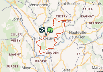
Randonnée de 11,1 km à découvrir à Auvergne-Rhône-Alpes, Haute-Savoie, Vallières-sur-Fier. Cette randonnée est proposée par Ladyclairdelune74.
Description
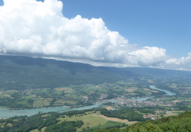
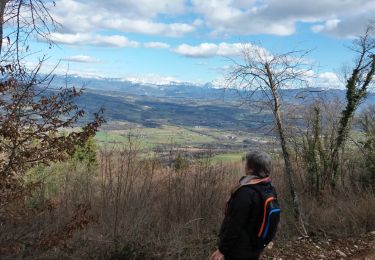
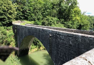
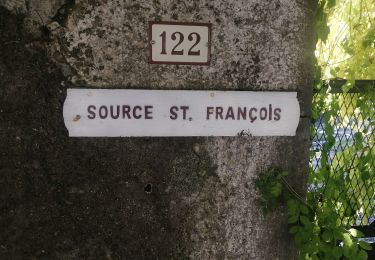
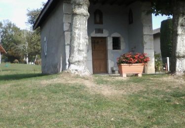
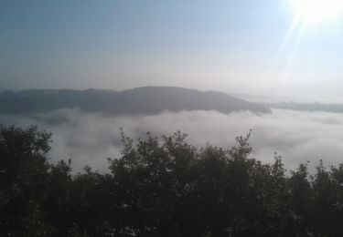
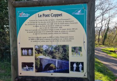
Circuit familial, principalement sur chemin, qui vous mènera le long des vergers typiques de l'Albanais. Tout au long du parcours vous pourrez également admirer un joli patrimoine bâti (châteaux et maisons fortes privés). Difficulté : vert.Peu après le départ, une descente jusqu'à un passage à gué obligera les moins aguerris à maîtriser leur vitesse. Puis le chemin remonte sur les hauteurs de Vallières-sur-Fier où vous pourrez observer de jolies vues avant de redescendre au niveau de Verlioz. Traversez prudemment la RD14. Vous passerez à proximité de l'entreprise Thomas Le Prince, spécialisée dans la transformation de fruits. Vous pourrez découvrir leurs produits dans leur magasin de vente directe. Puis, en approchant du Fier, faites le détour (150 mètres) jusqu'au Pont Coppet, l'un des plus anciens ponts de Haute-Savoie (construit en 1626). Soyez vigilants lors de la traversée de la RD910. Ensuite cheminez tranquillement au travers des nombreux vergers, le long du Fier. Il est possible en faisant un petit détour de découvrir un barrage. Une dernière montée vous permettra de rejoindre le chef-lieu.
Localisation
Commentaires
Randonnées à proximité
![Randonnée Marche Vallières-sur-Fier - VAL_DE_FIER_BALCONS - Photo](https://media.geolcdn.com/t/375/260/ext.jpg?maxdim=2&url=https%3A%2F%2Fservices.sitytrail.com%2FGeolivesWS%2FDownloadMedia.ashx%3FTrailID%3D603115%26Media%3Daae1b741-5652-4a0f-9677-926404386cfd.png)
![Marche Marche](https://static1.geolcdn.com/sitytour/trail-icons/101.png)
Marche
![](/images/other/stat-length.png)
![](https://static1.geolcdn.com/siteimages/upload/files/16400158638029165_repeat_loop_refresh_sync_direction_icon.png)
![Randonnée Marche Lornay - LE GROS FOUG: LORNAY - Photo](https://media.geolcdn.com/t/375/260/80c30a51-2af2-42e9-9c69-8f52a5cfd76e.jpg&format=jpg&maxdim=2)
![Marche Marche](https://static1.geolcdn.com/sitytour/trail-icons/101.png)
Marche
![](/images/other/stat-length.png)
![](https://static1.geolcdn.com/siteimages/upload/files/16400158638029165_repeat_loop_refresh_sync_direction_icon.png)
![Randonnée Marche Sales - Pont Coppet - Photo](https://media.geolcdn.com/t/375/260/6c149bdc-b543-49af-8bcc-762f821120c9.jpeg&format=jpg&maxdim=2)
![Marche Marche](https://static1.geolcdn.com/sitytour/trail-icons/101.png)
Marche
![](/images/other/stat-length.png)
![](https://static1.geolcdn.com/siteimages/upload/files/16400158638029165_repeat_loop_refresh_sync_direction_icon.png)
![Randonnée V.T.T. Moye - 74- Le Gros Foug - Photo](https://media.geolcdn.com/t/375/260/ext.jpg?maxdim=2&url=https%3A%2F%2Fstatic1.geolcdn.com%2Fsiteimages%2Fupload%2Ffiles%2F1524743154velo.jpg)
![V.T.T. V.T.T.](https://static1.geolcdn.com/sitytour/trail-icons/202.png)
V.T.T.
![](/images/other/stat-length.png)
![](https://static1.geolcdn.com/siteimages/upload/files/16400158638029165_repeat_loop_refresh_sync_direction_icon.png)
![Randonnée Marche Vaulx - Autour de la commune de Vaulx 74150 - Photo](https://media.geolcdn.com/t/375/260/35bef058-8551-405b-b358-defe586c3f49.jpg&format=jpg&maxdim=2)
![Marche Marche](https://static1.geolcdn.com/sitytour/trail-icons/101.png)
Marche
![](/images/other/stat-length.png)
![](https://static1.geolcdn.com/siteimages/upload/files/16400158638029165_repeat_loop_refresh_sync_direction_icon.png)
![Randonnée Marche Vaulx - VAULX - Photo](https://media.geolcdn.com/t/375/260/ext.jpg?maxdim=2&url=https%3A%2F%2Fservices.sitytrail.com%2FGeolivesWS%2FDownloadMedia.ashx%3FTrailID%3D644952%26Media%3Dbcbae396-3b96-4dce-ac7c-01ea10635118.jpg)
![Marche Marche](https://static1.geolcdn.com/sitytour/trail-icons/101.png)
Marche
![](/images/other/stat-length.png)
![](https://static1.geolcdn.com/siteimages/upload/files/16400158638029165_repeat_loop_refresh_sync_direction_icon.png)
![Randonnée Marche Lornay - TOUR_DE_LORNAY - Photo](https://media.geolcdn.com/t/375/260/ext.jpg?maxdim=2&url=https%3A%2F%2Fservices.sitytrail.com%2FGeolivesWS%2FDownloadMedia.ashx%3FTrailID%3D464342%26Media%3Df1f83b78-77ac-4f54-a499-03193cc71ccc.jpg)
![Marche Marche](https://static1.geolcdn.com/sitytour/trail-icons/101.png)
Marche
![](/images/other/stat-length.png)
![](https://static1.geolcdn.com/siteimages/upload/files/16400158638029165_repeat_loop_refresh_sync_direction_icon.png)
![Randonnée Marche nordique Vallières-sur-Fier - Val de Fier - Croix saint-André - Photo](https://media.geolcdn.com/t/375/260/ext.jpg?maxdim=2&url=https%3A%2F%2Fservices.sitytrail.com%2FGeolivesWS%2FDownloadMedia.ashx%3FTrailID%3D345602%26Media%3Dfix__20140916090536.jpg)
![Marche nordique Marche nordique](https://static1.geolcdn.com/sitytour/trail-icons/102.png)
Marche nordique
![](/images/other/stat-length.png)
![](https://static1.geolcdn.com/siteimages/upload/files/16400158638029165_repeat_loop_refresh_sync_direction_icon.png)
![Randonnée Marche Vallières-sur-Fier - VALLIERES 3 - Photo](https://media.geolcdn.com/t/375/260/3b739b08-99b9-4f73-be96-669ebf98b262.jpg&format=jpg&maxdim=2)
![Marche Marche](https://static1.geolcdn.com/sitytour/trail-icons/101.png)
Marche
![](/images/other/stat-length.png)
![](https://static1.geolcdn.com/siteimages/upload/files/16400158638029165_repeat_loop_refresh_sync_direction_icon.png)